


— Blogs —
—Products—
 Consumer hotline +8618073152920
 WhatsApp:+8615367865107
Address:Room 102, District D, Houhu Industrial Park, Yuelu District, Changsha City, Hunan Province, China
Product knowledge
Time:2026-03-28 16:40:24 Popularity:6
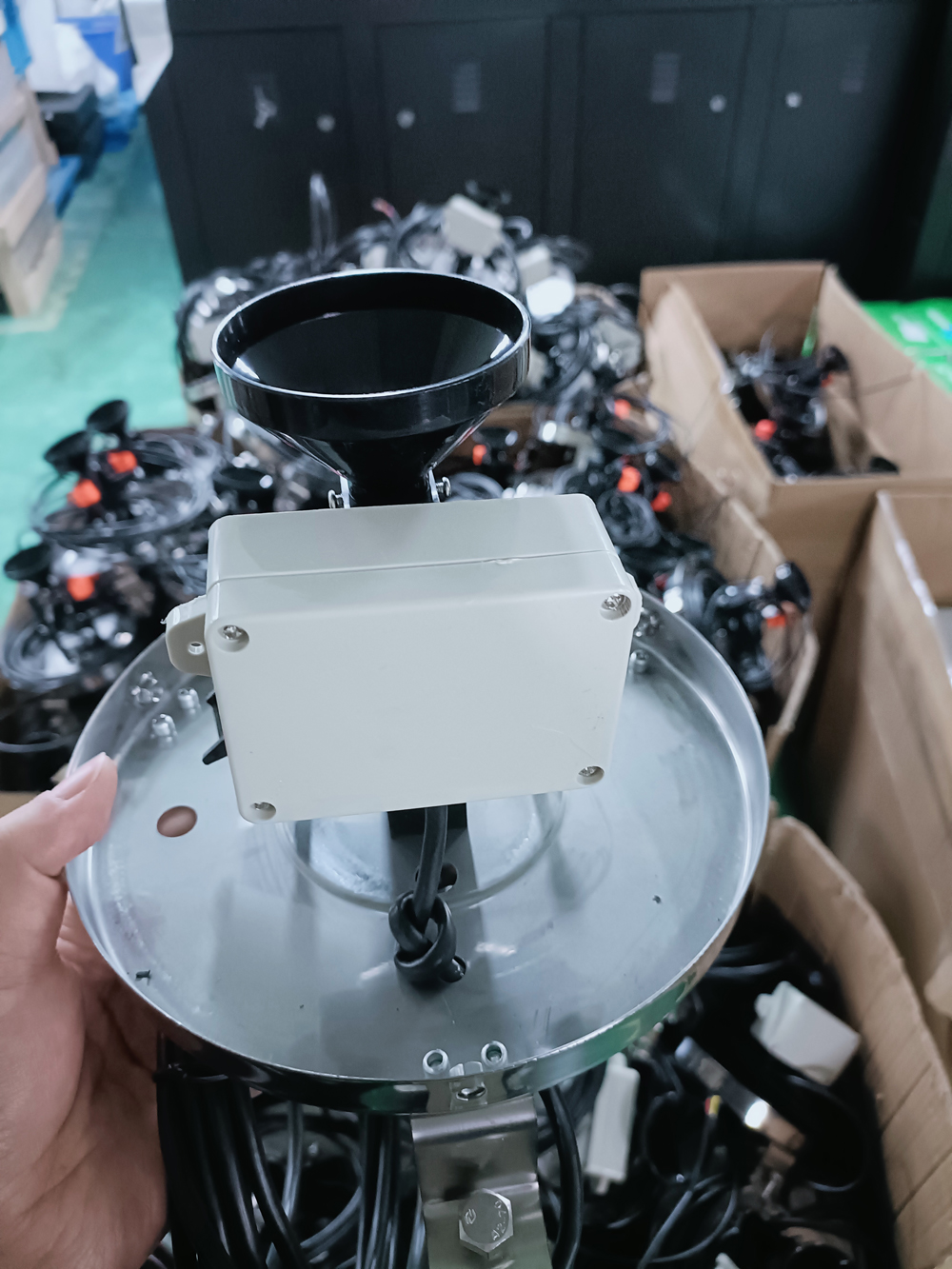
NiuBoL Rainfall Monitoring Station – High-precision rainfall sensor for real-time precipitation intensity and cumulative rainfall collection, supporting wireless remote transmission.
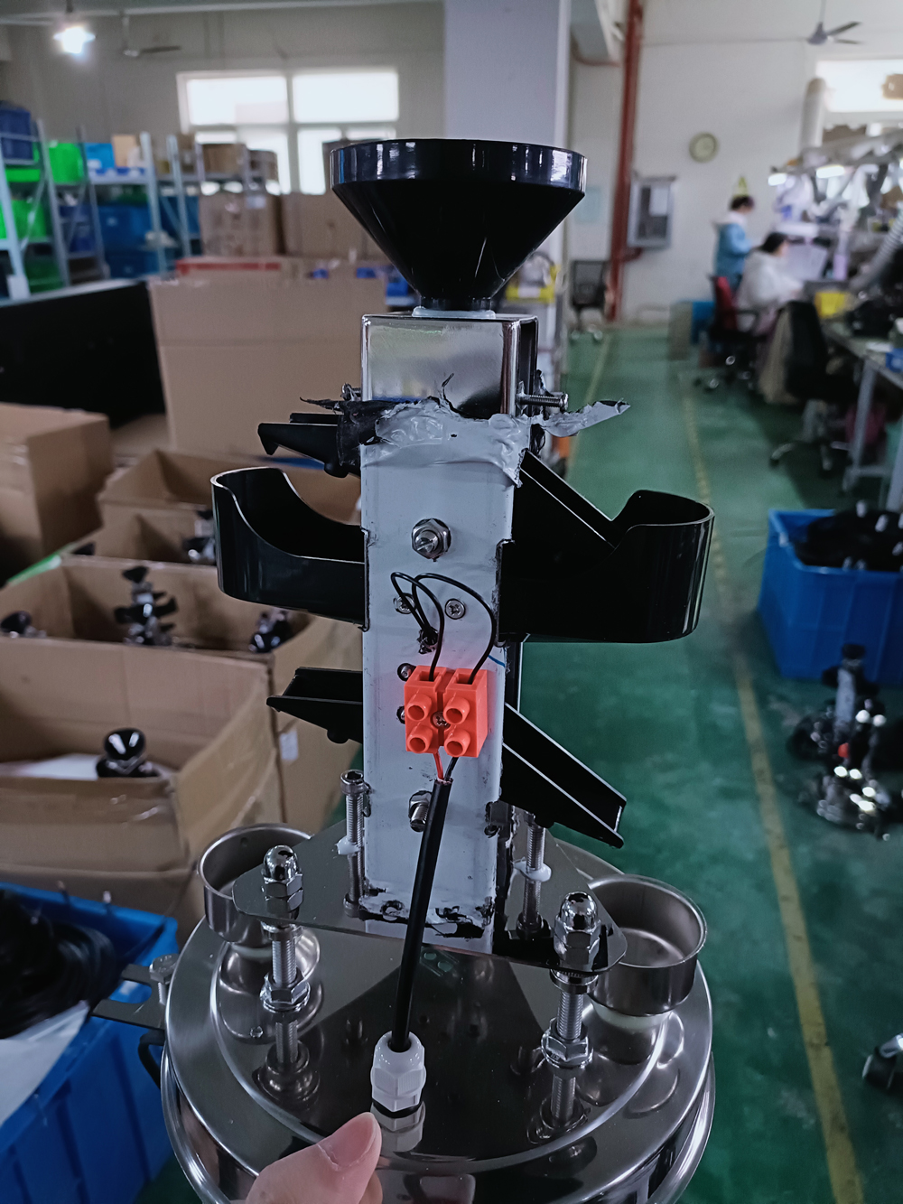
The rainfall monitoring station is an automated meteorological and hydrological observation device specially used for continuous measurement of precipitation and precipitation intensity. It mainly consists of a rainfall sensor, data acquisition unit, communication module and power supply system. It can achieve high-precision recording of minute-level rainfall intensity, hourly cumulative rainfall and daily cumulative rainfall, and upload data to the water and rainfall monitoring platform in real time through 4G/RJ45 or RS485 interfaces.
Different from manual observation rain gauges, the automatic rainfall monitoring station supports unattended operation, with strong data timeliness and good continuity. It is an important part of the national hydrometeorological observation and forecasting service system. In engineering practice, rainfall monitoring stations are often networked with sensors such as water level, flow and soil moisture to form a multi-element water and rainfall automatic monitoring station, providing basic data for watershed flood control dispatching, urban drainage management and geological disaster warning.

Precipitation is a key triggering factor for floods, urban waterlogging, landslides, debris flows and droughts. The NiuBoL rainfall monitoring station plays an important role in the following aspects through real-time and accurate precipitation data collection:
Urban ground hardening leads to a decrease in the permeability of the underlying surface, and heavy precipitation easily exceeds the carrying capacity of the drainage pipe network. Combined with urban hydrological models, rainfall monitoring stations can calculate rainfall intensity peaks and cumulative rainfall in real time, providing quantitative basis for drainage pump station start/stop and regulation facility dispatching, improving the accuracy of waterlogging warning, and supporting data needs for sponge city construction.
In southern mountainous and hilly areas, short-term heavy precipitation easily triggers flash floods, landslides and debris flows. Rainfall monitoring stations can monitor hourly rainfall or short-term rainfall intensity. When the set threshold is reached, they automatically trigger graded warnings to assist relevant departments in organizing personnel evacuation and engineering rescue in advance, reducing losses of life and property.
Long-term low rainfall or uneven precipitation distribution can lead to conflicts between agricultural and industrial water use. The accumulation of historical rainfall data can be used to analyze the correlation between precipitation patterns and drought disasters, providing decision-making support for reservoir water storage, agricultural irrigation dispatching and water resources optimization during dry seasons.
Cumulative rainfall sequences provide measured basis for dike height verification, drainage system design and flood discharge capacity assessment, supporting scientific planning of regional disaster prevention and mitigation projects.
Through wireless remote transmission, rainfall data can be directly connected to hydrological databases or GIS platforms to achieve multi-source data fusion and visual analysis, significantly shortening disaster response time.
Site selection quality directly affects the representativeness and accuracy of monitoring data. NiuBoL recommends the following analysis during the project planning stage:
Representativeness principle: Combine urban waterlogging risk assessment, historical disaster records, drainage facility distribution and topographic features to select typical locations that can reflect regional precipitation characteristics.
Density requirements: The station spacing in general areas should not exceed 10km. High-risk waterlogging or key protection areas can be densified to within 5km to form a reasonable monitoring grid.
Topographic and environmental conditions: Prioritize flat and open areas without tall buildings or tree obstructions to avoid airflow disturbance and rain shadow effects.
Interference avoidance: Stay away from transformers, high-voltage lines, radar and strong electromagnetic interference sources to ensure stable wireless communication signals (priority should be given to areas with good 4G coverage).
Safety and accessibility: Take into account equipment anti-theft and anti-damage requirements while facilitating later maintenance and inspection.
Correct site selection can minimize observation errors and ensure the usability of data in flood control decision-making.
To ensure data continuity and accuracy, a regular inspection and maintenance mechanism must be established. Common faults and handling methods are as follows:
Possible causes: Rain collector blockage, tipping bucket jamming, sensor accuracy drift or equipment damage.
Handling measures: Clean debris in the rain collector, check the flexibility of the tipping bucket action, and perform on-site accuracy calibration. If there is still no record during heavy rainfall, check the sensor hardware status.
Possible causes: Sensor looseness, poor line contact, residual water in the tipping bucket or automatic tipping bucket flipping.
Handling measures: Tighten installation, clean residual water, and check line connection reliability.
Regularly (recommended monthly or after each heavy rainfall) clean the rain collector to prevent blockage by fallen leaves, bird droppings and insects.
Perform accuracy calibration once per quarter and use standard rainfall calibration equipment to verify measurement errors.
Check the communication module, antenna and power supply system to ensure stable data upload.
Pay attention to anti-freezing measures in winter to prevent tipping bucket sensors from being affected by icing.
Standardized maintenance can maintain data effectiveness above 95% and reduce monitoring blind spots caused by equipment failures.

Deployed in urban low-lying road sections, underground spaces and key drainage nodes, combined with rainfall and water level data to build waterlogging risk models, supporting intelligent linkage of pump stations and traffic restriction decisions.
Installed in mountainous and hilly watersheds and debris flow-prone gullies to monitor short-term rainfall intensity and process rainfall, providing input parameters for flash flood forecasting models and supporting the "call-and-response" mechanism and personnel evacuation.
Used for rainfall monitoring in dry farming areas or irrigation areas, combined with soil moisture data to guide irrigation dispatching and optimize water resource utilization efficiency.
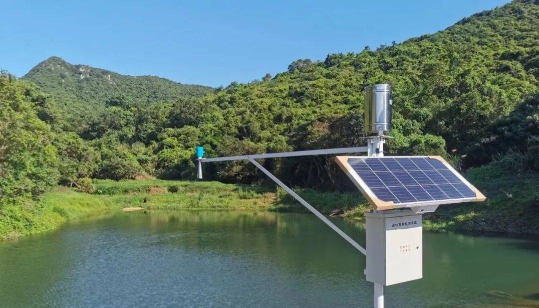
As an important node of the watershed water and rainfall monitoring network, it provides real-time basis for reservoir water storage and discharge balance and flood control storage capacity dispatching.
Provide precipitation background data for effect evaluation of green infrastructure such as rain gardens and permeable pavements, supporting verification of low-impact development (LID) technology.
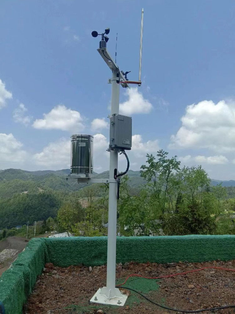
The NiuBoL rainfall monitoring station supports integration with sensors such as water level, wind speed, temperature and humidity to form a multi-parameter hydrometeorological automatic station, meeting the composite monitoring needs of different engineering projects.
The NiuBoL rainfall monitoring station adopts industrial-grade rainfall sensors, supporting tipping bucket rain gauges with a measurement range covering 0~4mm and accuracy meeting relevant national standards. The system integrates a data collector and wireless communication module, supporting MODBUS RTU protocol local output and 4G remote transmission. The low-power design is suitable for solar power supply, and the protection level above IP65 ensures long-term stable operation in the field.
Typical configurations can be combined with ultrasonic wind speed and direction instruments, temperature and humidity sensors, etc., to build an integrated small meteorological station, suitable for space-constrained or rapid deployment projects.
Q1. What is the main difference between rainfall monitoring stations and manual rainfall observation?
Automatic rainfall monitoring stations achieve unattended, continuous online monitoring. Data timeliness and continuity are far superior to manual observation and are suitable for flood control emergency needs.
Q2. What communication methods does the NiuBoL rainfall monitoring station support?
It supports RS485 local output (MODBUS protocol) and 4G wireless remote transmission, facilitating access to existing hydrological platforms.
Q3. How to determine whether the rainfall sensor needs calibration?
When there is no record for light rain, deviation in heavy rain records, or false records when there is no rain, on-site calibration is recommended.
Q4. What are the recommendations for the site selection density of automatic rainfall monitoring stations?
The station spacing in general areas should not exceed 10km. High-risk areas for waterlogging or geological disasters can be densified to within 5km.
Q5. Does the rainfall monitoring station support integration with other sensors?
Yes, it can be networked with water level gauges, wind speed and direction instruments, temperature and humidity sensors, etc., to form a multi-element water and rainfall monitoring station.
Q6. How to prevent rainfall sensor failures in winter?
Take anti-freezing measures, regularly check tipping bucket action, and use models with heating function when necessary.
Q7. What interference factors should be paid most attention to during installation?
Avoid tall obstructions, strong electromagnetic interference sources and turbulent areas. Ensure the rain collection opening is level and open.
Q8. What engineering projects is this system suitable for?
It is widely applicable to projects such as urban waterlogging monitoring, flash flood and geological disaster warning, watershed flood control, water conservancy irrigation area management and sponge city construction.

The rainfall monitoring station plays a basic data support role in flood control and drought relief, urban waterlogging prevention and control, and geological disaster warning. The NiuBoL rainfall monitoring station provides reliable precipitation monitoring solutions for system integrators, IoT solution providers, project contractors and engineering companies with its high-precision sensors, stable communication protocols and low-maintenance design.
Through scientific site selection, standardized maintenance and multi-element integration, the representativeness and usability of rainfall data can be significantly improved, helping to build a more resilient hydrometeorological monitoring network. In the context of climate change, strengthening rainfall monitoring capacity building is an important measure to improve regional disaster prevention and mitigation levels.
As a professional meteorological and hydrological equipment manufacturer, NiuBoL focuses on providing mature automatic rainfall monitoring products and system integration support for industry partners. If you need detailed technical parameters, site selection scheme design or project deployment guidance, please contact the professional team for further cooperation to jointly promote the application of water and rainfall monitoring technology in disaster prevention engineering.
 NBL-W-RS-Rain-sensors-instruction-manual-V4.0.pdf
NBL-W-DRS-Double-Tipping-Bucket-Rain-Sensor-Instruction-Manual.pdf
Related recommendations
Sensors & Weather Stations Catalog
 Agriculture Sensors and Weather Stations Catalog-NiuBoL.pdf
Weather Stations Catalog-NiuBoL.pdf
Agriculture Sensors Catalog-NiuBoL.pdf
Related products
 Combined air temperature and relative humidity sensor
 Soil Moisture Temperature sensor for irrigation
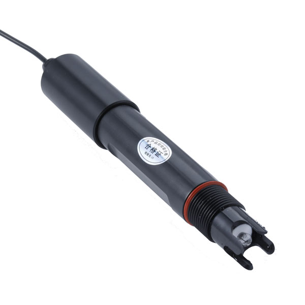 Soil pH sensor RS485 soil Testing instrument soil ph meter for agriculture
 Wind Speed sensor Output Modbus/RS485/Analog/0-5V/4-20mA
 Tipping bucket rain gauge for weather monitoring auto rainfall sensor RS485/Outdoor/stainless steel
 Pyranometer Solar Radiation Sensor 4-20mA/RS485

Screenshot, WhatsApp to identify the QR code
WhatsApp number:+8615367865107
(Click on WhatsApp to copy and add friends)

