


— Products —
 Consumer hotline +8618073152920
 WhatsApp:+8615367865107
Address:Room 102, District D, Houhu Industrial Park, Yuelu District, Changsha City, Hunan Province, China
All products
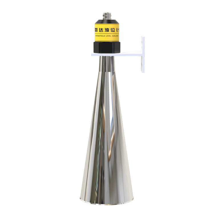
Water level sensor for river is an important device for continuous river water level monitoring. NiuBoL radar water level gauge is based on 77–79GHz FMCW millimeter wave radar technology, featuring high precision, non-contact measurement, strong anti-interference capability, and is widely used in flood warning, hydrological monitoring, smart water conservancy, and IoT systems.
Tel/WhatsApp:+8615367865107
Email:Arvin@niubol.com +Nearly 100 partner companies in more than 75 countries. We are committed to providing high-quality, practical products to meet your needs and help you solve problems. Our products comply with international standards and are certified with ISO, CE and RoHS.Product Details
River water level continuous and precise monitoring is a key basic data source in flood control and disaster reduction, water resource management, hydrological research, and smart water conservancy systems. Compared with traditional contact liquid level gauges, Water level sensor for river based on millimeter wave radar technology is gradually becoming the mainstream choice for water level monitoring in rivers, reservoirs, and open channels.
The NiuBoL radar water level gauge is specially designed for complex outdoor environments. It can stably output high-precision water level data under conditions such as strong wind, rainfall, sediment, and water surface fluctuations, meeting the needs of long-term unattended monitoring.

The radar water level gauge (Water level sensor) is a FMCW (Frequency Modulated Continuous Wave) millimeter wave radar water level measurement device operating in the 77GHz~79GHz frequency band. It calculates the transmission time difference by transmitting high-frequency electromagnetic waves and receiving the reflected signal from the water surface, thereby achieving non-contact water level measurement.
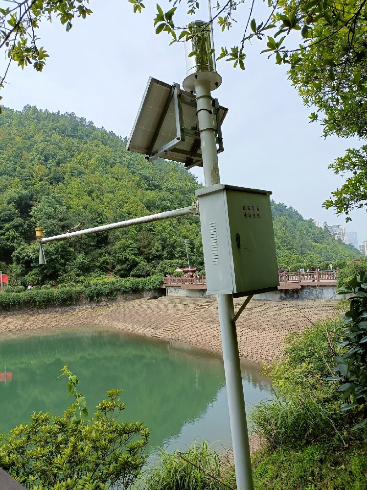
The NiuBoL radar water level gauge has a maximum measurement range of up to 65 m, with a blind zone less than 15 cm. It is particularly suitable for long-distance monitoring of open water bodies such as rivers, channels, and reservoirs. The device adopts a nut fixing method and can be quickly installed in conjunction with hydrological and rainfall monitoring poles or monitoring boxes, facilitating engineering deployment.
The radar water level gauge uses FMCW technology to calculate distance through the frequency difference between the linearly frequency-modulated transmitted signal and the echo signal. Compared with pulse radar, this technology has higher ranging resolution and anti-noise capability, making it particularly suitable for complex water surface environments.
Higher bandwidth, resulting in higher measurement resolution
More sensitive to water surface reflection, with stable ranging accuracy
Smaller antenna size, more compact overall structure

Based on self-developed CMOS millimeter wave RF chip, with highly integrated RF architecture and higher signal-to-noise ratio
Large working bandwidth, water level measurement resolution up to 1 mm
Narrowest 8° beam angle, effectively reducing interference from riverbanks, bridge piers, etc.
Integrated lens design, small and compact size, more convenient for installation and maintenance
Non-contact measurement, unaffected by water quality, sediment, or floating objects
Low power consumption design, suitable for solar power supply systems
Industrial-grade structural design, suitable for long-term outdoor operation
| Parameter | Specification |
|---|---|
| Power Supply Voltage | DC 10–30 V |
| Maximum Power Consumption | 0.6 W |
| Transmission Frequency | 77 GHz ~ 79 GHz |
| Measurement Range | 0.15 m ~ 65 m |
| Resolution | 1 mm |
| Measurement Accuracy | ±1 mm (4 m, 40%RH, 25℃) |
| Beam Angle | 8° |
| Operating Temperature & Humidity | -40℃ ~ +80℃, 0%RH ~ 95%RH (non-condensing) |
| Communication Interface | RS485 |
| Protection Rating | IP67 |

Flood Control and Water Level Early Warning
Real-time acquisition of river water level change trends, providing reliable data foundation for flood control dispatching and emergency response.
Hydrological Stations and Basin Monitoring
As an important component of automatic hydrological stations, continuously collecting water level data over the long term for hydrological model analysis.
Smart Water Conservancy and IoT Systems
Access to RTU, DTU or data collectors via RS485 interface to achieve remote transmission and cloud management.
River Regulation and Ecological Monitoring
Assisting in evaluating the impact of river water level changes on the ecological environment and supporting scientific governance decisions.
| Comparison Dimension | Radar Water Level Gauge | Drop-in Liquid Level Gauge | Ultrasonic Liquid Level Gauge |
|---|---|---|---|
| Measurement Method | Non-contact | Contact | Non-contact |
| Anti-sediment Capability | Extremely strong | Weak | Medium |
| Maintenance Requirement | Low | High | Medium |
| Affected by Water Quality | None | Yes | Yes |
| Installation Position | Above | In water | Above |
| Suitable for Rivers | Very suitable | Not recommended | Partially suitable |

Before installation, check whether the sensor appearance and accessories are complete
The sensor must be installed vertically to the water surface
Avoid interference objects such as riverbanks, bridge piers, railings, etc. within the beam range
Ensure the installation structure is stable to prevent long-term vibration
Reasonably select the installation height to avoid exceeding the measurement range

Is the radar water level gauge suitable for turbulent rivers?
Yes. Radar measurement does not contact the water body and is not affected by water flow velocity.
Will heavy rain or fog affect the measurement?
Millimeter waves have strong penetration ability against rain and fog, and the measurement remains stable under normal rainfall conditions.
Will floating objects on the river surface cause false measurements?
The narrow beam design can effectively reduce interference from floating objects, with minimal overall impact.
Is it compatible with existing hydrological systems?
Yes. It supports RS485 interface and can be connected to most hydrological RTUs and data platforms.
Does the radar water level gauge require regular calibration?
Under normal circumstances, frequent calibration is not required, and long-term stability is high.
Does it support solar power supply?
Yes. The low power consumption design is very suitable for solar power supply solutions.

Water level sensor for river is an indispensable key device in modern river water level monitoring. With advantages such as high precision, non-contact, strong anti-interference, and low maintenance cost, the NiuBoL radar water level gauge demonstrates significant value in flood control, hydrological monitoring, smart water conservancy, and IoT systems.
For river water level monitoring projects that require long-term, stable, and unattended operation, millimeter wave radar water level gauges are becoming a more reliable and efficient solution.
Sensors & Weather Stations Catalog
 Agriculture Sensors and Weather Stations Catalog-NiuBoL.pdf
Weather Stations Catalog-NiuBoL.pdf
Agriculture Sensors Catalog-NiuBoL.pdf
Water Quality Sensor Catalog-NiuBoL.pdf
Related recommendations
 Multi-Depth Soil Sensor RS485
 TDR Soil Moisture Sensor
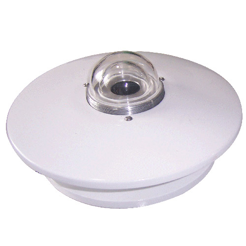 Pyranometer Solar Radiation Sensors
 Soil ph sensor
 Tipping Bucket Rain Gauge
 Air Temperature and Humidity Sensor

Screenshot, WhatsApp to identify the QR code
WhatsApp number:+8615367865107
(Click on WhatsApp to copy and add friends)
