


— Solutions —
—Products—
 Consumer hotline +8618073152920
 WhatsApp:+8615367865107
Address:Room 102, District D, Houhu Industrial Park, Yuelu District, Changsha City, Hunan Province, China
Weather & Environmental
Time:2025-11-13 13:53:39 Popularity:950
With accelerating urbanization, high-rise buildings, dense pavement, and relatively reduced green spaces have created distinct urban climate characteristics. The “urban forest” of steel and concrete disrupts natural climate balance, leading to issues such as the urban heat island (UHI) effect, venturi wind effects, urban flooding, and localized heavy rainfall.
In summer, central urban temperatures can be 3–8°C higher than suburban areas, increasing air conditioning loads, energy consumption, and carbon emissions, while elevating risks of heatstroke and cardiovascular diseases. Short-duration heavy rains create a “rain island effect,” while dense high-rises generate venturi winds and hinder pollutant dispersion, forming a “pollution island” that further impacts resident comfort and health.
Driven by dual-carbon goals and smart city initiatives, urban climate monitoring has shifted from passive response to proactive regulation. However, traditional weather stations located on urban fringes fail to reflect microclimate variations within the city. Fragmented monitoring devices lack coordinated analysis, unable to support UHI cause tracing or flood risk prediction.
Leveraging years of microclimate monitoring expertise, NiuBoL launches a customized urban climate monitoring solution with a three-tier monitoring network covering streets, communities, and districts. Through high-density networking + multi-parameter fusion sensing + intelligent analysis, it provides scientific evidence for urban planning, ecological governance, and emergency management.

- Insufficient Monitoring Density: Traditional stations spaced 5–10 km apart fail to capture localized differences in commercial districts, parks, or residential areas, creating blind spots in UHI cores and flood-prone zones.
- Single-Parameter Focus: Most monitoring focuses only on temperature and precipitation, lacking data on underlying surface temperature, building density, or vegetation coverage, hindering UHI cause analysis.
- Delayed Data Response: Localized storms and convective weather last briefly; hourly sampling cannot capture real-time changes, delaying flood warnings.
- Lack of System Integration: Climate data is disconnected from urban planning and municipal management systems, preventing actionable outcomes.
- High Maintenance Costs: Limited space in urban core areas and frequent manual maintenance result in annual costs of up to tens of thousands of RMB per site.

- Full Microclimate Coverage: Establish a 500-meter high-density monitoring network to capture UHI, localized rainfall, and venturi winds with Tier-1 industry accuracy.
- Multi-Dimensional Cause Tracing: Simultaneously collect meteorological and urban surface data to quantify the impact of building density and vegetation on UHI, enabling targeted governance.
- Real-Time Emergency Warning: Extreme weather response in ≤1 second; automatic alerts when UHI intensity or short-term rainfall exceeds thresholds, providing lead time for flood control and heat mitigation.
- Planning Data Empowerment: Integrate with smart city platforms to support detailed planning, green space design, and traffic planning.
- Low-Consumption Intelligent Maintenance: Annual equipment failure rate ≤0.8%, supporting remote calibration and fault prediction, reducing maintenance costs by over 70%.
- Microclimate Multi-Parameter Fusion Sensing: Infrared temperature arrays measure air and surface temperatures (±0.2°C accuracy); ultrasonic anemometers detect 0.1 m/s micro-wind changes; tipping bucket rain gauges with 0.1 mm resolution; compact design fits urban installation constraints.
- LoRa + 4G/5G Dual-Mode Transmission: Low power in dense urban areas; reliable connectivity in remote zones.
- Smart City Data Integration: Standardized API interfaces enable seamless docking with planning GIS, municipal management, and emergency command systems; supports BIM integration to simulate UHI effects in new developments and optimize layouts and greening in advance.
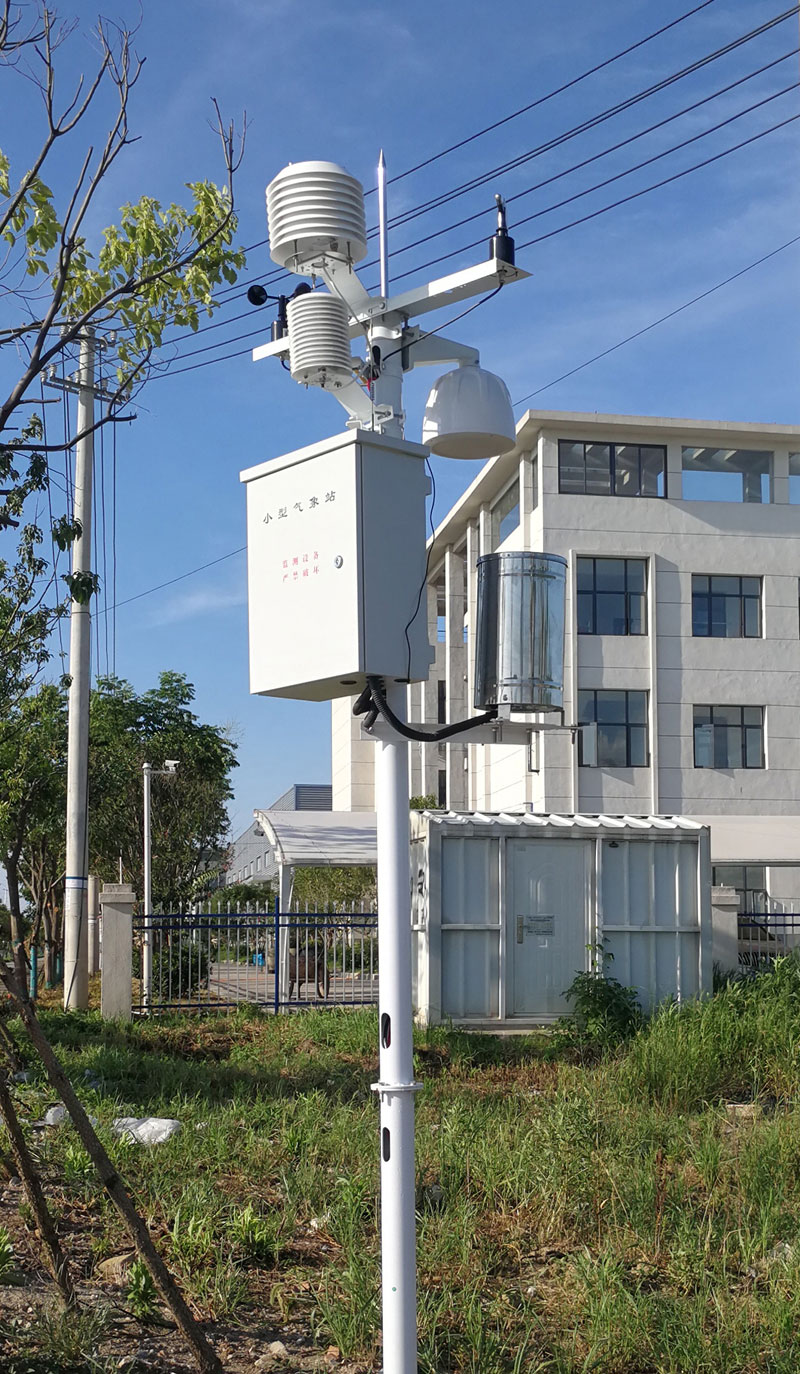
- NiuBoL Urban Microclimate Station: Measures 5 parameters (air temperature/humidity, pressure, wind speed/direction, rainfall); solar + lithium battery powered; wall- or pole-mounted.
- NiuBoL Commercial District UHI Monitoring Station: Adds PM2.5 and CO₂; LED screen displays UHI levels and health advisories.
- NiuBoL Flood Monitoring Station: Deployed in low-lying roads and underpasses; measures water depth and accumulation rate with audible/visual alarms.
Supports 16 sensor inputs via LoRa/RS485; 64GB onboard storage (3-month offline caching); edge computing for UHI judgment and flood alerts; low-power design compatible with solar power.
- Microclimate Monitoring Center: Map-based display of monitoring points; color-coded (red-yellow-green) UHI and flood risk; 1-second refresh and historical playback.
- UHI Analysis Center: Generates heat maps and diurnal curves; correlates with building and greening data; provides governance recommendations.
- Equipment O&M Center: Remote monitoring of power, signal, and calibration status; automatic alerts and work order generation.
- Planning Web Portal: For planning institutes and natural resource departments to simulate UHI and optimize layouts.
- Municipal Mobile App: Real-time alerts for flood and venturi wind; dispatches drainage and greening operations.
- Command Center Dashboard: Panoramic emergency display supporting multi-department coordination.
- Network planning: 500 m spacing in core areas, 1 km in suburbs.
- On-site survey for power, signal, and mounting space.
- Pre-commissioning and platform integration.
- Pole-mounted or buried fixation.
- System joint commissioning and acceptance.
- Fixed stations sample every 10 seconds, mobile every 5 seconds.
- Data processed by collector and uploaded to cloud.
- Intelligent data cleaning removes anomalies; interpolation fills blind spots.
- Deep analysis produces UHI distribution, cause reports, and flood risk forecasts.
- Provide UHI simulation and green space optimization for planning and design.
- Push governance and drainage strategies to municipal operations.
- Rapid risk point localization for emergency response.
- Quantified data support for policy formulation.

- High-Density Networking → No microclimate blind spots
- Multi-Parameter Fusion → Precise cause tracing
- Real-Time Response → Efficient emergency handling
- Smart Integration → Direct planning implementation
- Urban-Adapted Design → Controllable O&M costs
- Quantifiable Evaluation → Visible governance outcomes
- High Technical Cost: Mitigated via “basic monitoring + on-demand expansion” and government-led shared infrastructure models.
- Site Adaptability: Anti-collision shells, IP65 waterproof sealing, strategic placement avoiding building shadows; temperature compensation algorithms ensure accuracy.
- Data Sharing Risks: Tiered access control, national cryptographic encryption, standardized data conversion, and sharing protocols ensure security.
- AI Prediction: Forecast UHI evolution and flood risks using historical data and machine learning for preemptive resource allocation.
- Satellite Remote Sensing + UAV Integration: Supplement panoramic urban climate data to enhance coverage.
- Space-Air-Ground Integrated Monitoring: Combine ground micro-stations, drones, and satellites for multi-scale, all-weather monitoring.
- Digital Twin City: Integrate with BIM/GIS to simulate planning impacts on urban climate, supporting low-carbon, livable city development.

A1: NiuBoL collects both air and surface temperatures with 500 m high-density networking, revealing street-level microclimate differences.
A2: Device diameter ≤15 cm, hoop-mounted at ≥2 m height, withstands 100 kg impact.
A3: Provides standard HTTP/MQTT API interfaces; technical team assists with integration.
A4: Triple protection: IP65 waterproofing + large local storage + cloud backup.
NiuBoL is a professional enterprise specializing in urban microclimate monitoring. Focused on urban meteorological equipment and intelligent platforms, it holds RoHS, ISO9001, and other certifications. With 60 global service outlets, it delivers full-lifecycle services from survey → construction → operation & maintenance, empowering urban climate governance and smart city development.

Urban climate monitoring is the key infrastructure to address “urban maladies” such as heat islands and flooding, and a core component of smart city construction. The NiuBoL solution is built on high-density precise sensing, powered by intelligent analysis and smart integration, forming a complete service chain from data collection to planning application. It resolves the pain points of traditional monitoring — poor coverage, low accuracy, difficult application. In the future, space-air-ground integrated monitoring fusing AI and satellite remote sensing will further enhance governance precision, creating livable, safe, and resilient smart cities.
Prev:no more
Next:Environmental Pollution Monitoring — Air Pollutant Detection, Industrial Monitoring
Related recommendations
Sensors & Weather Stations Catalog
 Agriculture Sensors and Weather Stations Catalog-NiuBoL.pdf
Weather Stations Catalog-NiuBoL.pdf
Agriculture Sensors Catalog-NiuBoL.pdf
Water Quality Sensor Catalog-NiuBoL.pdf
Related products
 Combined air temperature and relative humidity sensor
 Soil Moisture Temperature sensor for irrigation|NBL-S-THR
 Soil pH sensor RS485 soil Testing instrument soil ph meter for agriculture |NBL-S-PH
 Wind Speed sensor Output Modbus/RS485/Analog/0-5V/4-20mA
 Tipping bucket rain gauge for weather monitoring auto rainfall sensor RS485/Outdoor/stainless steel
 Pyranometer Solar Radiation Sensor 4-20mA/RS485

Screenshot, WhatsApp to identify the QR code
WhatsApp number:+8615367865107
(Click on WhatsApp to copy and add friends)
