


— Blogs —
—Products—
 Consumer hotline +8618073152920
 WhatsApp:+8615367865107
Address:Room 102, District D, Houhu Industrial Park, Yuelu District, Changsha City, Hunan Province, China
Product knowledge
Time:2025-09-27 16:37:32 Popularity:889
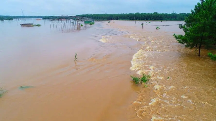
The Strategic Sentinel: Maximizing Coastal Resilience with Weather Station Networks
Coastal zones are the front lines of climate change. Rising sea levels and intensifying storm systems are rapidly turning quiet shores into high-hazard areas. In this critical environment, weather station networks are not a luxury; they are sophisticated early warning systems that safeguard lives and protect vast economic infrastructure. These compact, automated units provide the hyperlocal, high-resolution data needed to transition from reactive response to proactive, predictive defense.
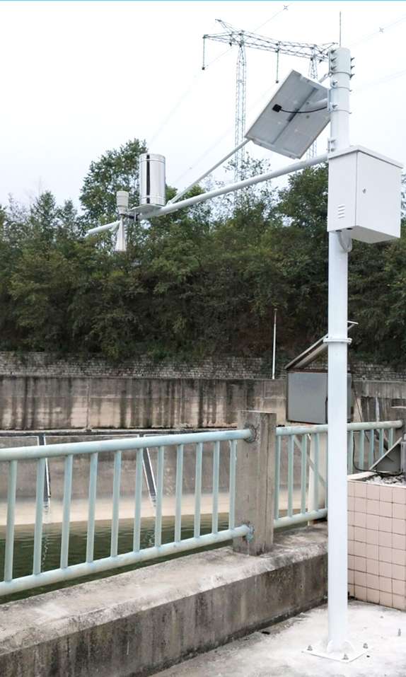
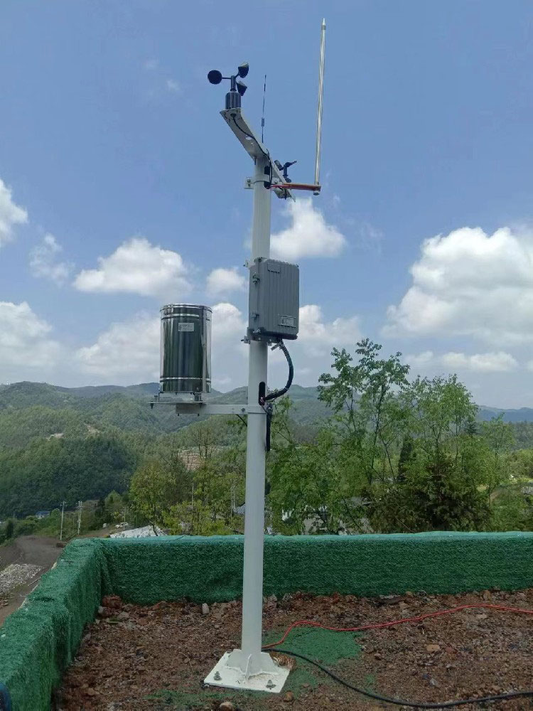
The effectiveness of coastal defense hinges on integrating specialized, reliable sensors to capture all elements of a flooding threat:
| Sensor Type | Function | Value Proposition |
| Barometers | Detect rapid atmospheric pressure drops and sustained low pressure. | Immediate indicator of approaching severe storms and strong low-pressure systems. |
| Ultrasonic/Radar Sensors | Non-contact measurement of water levels, tide dynamics, and wave heights. | Provides accurate storm surge data while minimizing maintenance from biofouling. |
| Anemometers | Measures wind speed and direction. | The primary data point for forecasting surge intensity and localized wind shear. |
| Rain Gauges | Records precipitation intensity and duration. | Crucial input for predicting pluvial flooding (rain-induced) when drainage is tide-restricted. |
By networking these local feeds with national meteorological data (e.g., NOAA buoy systems), coastal managers gain the granular insight necessary to spot localized anomalies—a capability vital for accurate, minute-by-minute forecasting.
Beyond the Alert: Building Long-Term Resilience
The value proposition of high-fidelity weather stations extends far beyond the immediate emergency. Long-term, verifiable data logs are indispensable tools for comprehensive climate adaptation and infrastructure planning.
Refined Hydrodynamic Models: High-resolution sensor data fuels sophisticated inundation models. This allows planners to simulate various catastrophe scenarios and accurately refine flood risk maps at the neighborhood level, guiding targeted protection efforts.
Coastal Engineering Decisions: Continuous data on water level variability and wave energy informs effective coastal engineering. It guides decisions on where to invest in hard defenses (seawalls, levees) versus soft solutions (dune restoration, mangrove planting).
Actuarial Certainty: Objective, timestamped data is invaluable for municipal and private sectors in quantifying actuarial risk. This is essential for transparent ESG reporting, updating local building codes, and establishing equitable insurance premiums.
The Return on Investment (ROI) for these systems is measured in avoided damages, reduced business interruption, and preserved property values.
Minimized Response Costs: Targeted warnings reduce the scope of unnecessary evacuations and resource mobilization.
Reduced Physical Damage: Protecting critical assets and infrastructure from unexpected flooding events.
To ensure operational continuity in corrosive, high-wind, and saline conditions, systems must be robustly engineered:
Durability Standards: Equipment must be IP66+ rated for superior resistance to dust, wind, and saltwater spray, typically utilizing advanced corrosion-resistant materials.
Power and Transmission: Systems rely on robust solar power and low-power, long-range wireless protocols (like LoRaWAN) to ensure reliable data transmission from remote coastal sites.
Mitigation of Maintenance: While submerged sensors may require periodic maintenance to manage biofouling, the system design focuses on utilizing elevated and non-contact sensors where possible, ensuring data availability remains high.
For coastal managers and urban planners worldwide, integrating these data feeds with Geographic Information Systems (GIS) transforms raw numbers into dynamic, visual risk intelligence. These vigilant sentinels provide the definitive data required to safeguard our most vulnerable economic hubs.

Ready to upgrade your coastal defense strategy with high-fidelity environmental intelligence? Contact us today to discuss how our integrated weather station solutions can transform your risk management.
Prev:Why Smallholder Farmers Need Their Own Weather Stations
Next:How Dust IQ Sensors Improve Solar Energy Projects in the Middle East
Related recommendations
Sensors & Weather Stations Catalog
 Agriculture Sensors and Weather Stations Catalog-NiuBoL.pdf
Weather Stations Catalog-NiuBoL.pdf
Agriculture Sensors Catalog-NiuBoL.pdf
Water Quality Sensor Catalog-NiuBoL.pdf
Related products
 Combined air temperature and relative humidity sensor
 Soil Moisture Temperature sensor for irrigation|NBL-S-THR
 Soil pH sensor RS485 soil Testing instrument soil ph meter for agriculture |NBL-S-PH
 Wind Speed sensor Output Modbus/RS485/Analog/0-5V/4-20mA
 Tipping bucket rain gauge for weather monitoring auto rainfall sensor RS485/Outdoor/stainless steel
 Pyranometer Solar Radiation Sensor 4-20mA/RS485

Screenshot, WhatsApp to identify the QR code
WhatsApp number:+8615367865107
(Click on WhatsApp to copy and add friends)
