


— Blogs —
—Products—
 Consumer hotline +8618073152920
 WhatsApp:+8615367865107
Address:Room 102, District D, Houhu Industrial Park, Yuelu District, Changsha City, Hunan Province, China
Product knowledge
Time:2026-06-14 18:56:34 Popularity:174
A farmland microclimate weather monitoring station gives agricultural IoT projects a localized data foundation. Instead of relying only on regional weather forecasts, integrators can deploy site-level sensors to understand the specific temperature, humidity, wind, rainfall, radiation, and soil conditions that influence crop management and risk response.
Agriculture is highly sensitive to external weather conditions. Rainstorms, drought, frost, heat waves, and wind events can reduce yield, damage infrastructure, and disrupt field operations. A farmland microclimate station helps project owners move from delayed observation to structured monitoring and early decision support.
For system integrators, the station is a data layer that can be connected with irrigation systems, farm management platforms, disease warning models, greenhouse controllers, and disaster prevention workflows. The business value is strongest when weather data becomes part of a larger agricultural service package rather than a standalone display.
A practical farmland microclimate station may include an ultrasonic weather sensor, rainfall sensor, solar radiation or illuminance sensor, soil temperature and moisture sensor, data logger, solar power supply, 4G or Ethernet communication module, and a cloud platform. The selected parameters should match the crop type, site location, irrigation method, and management objective.
NiuBoL sensors with RS485 MODBUS output can be connected to industrial gateways and data collectors. This allows integrators to standardize data acquisition across distributed farmland points, orchards, greenhouses, livestock areas, rural roads, and ecological monitoring zones.
| Module | Recommended Function | Integration Purpose |
|---|---|---|
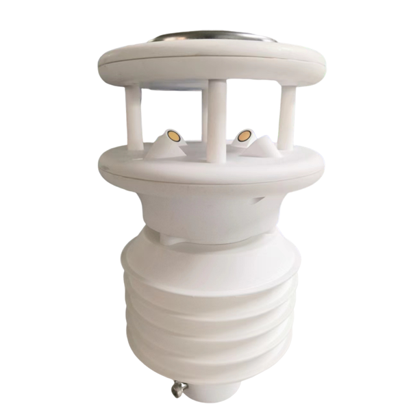
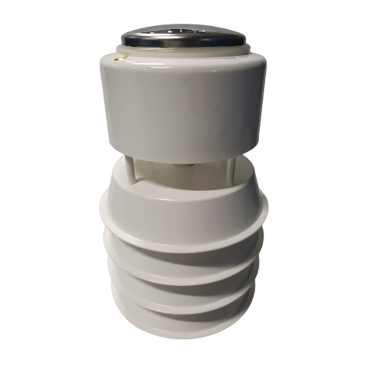
| Ultrasonic Weather Sensor | NBL-W-10GUWS ultrasonic weather station for wind speed, wind direction, temperature, humidity, pressure, and optional extended parameters | Core atmospheric data acquisition |
| Rainfall Sensor | Rainfall intensity and accumulated rainfall | Irrigation adjustment and disaster warning |
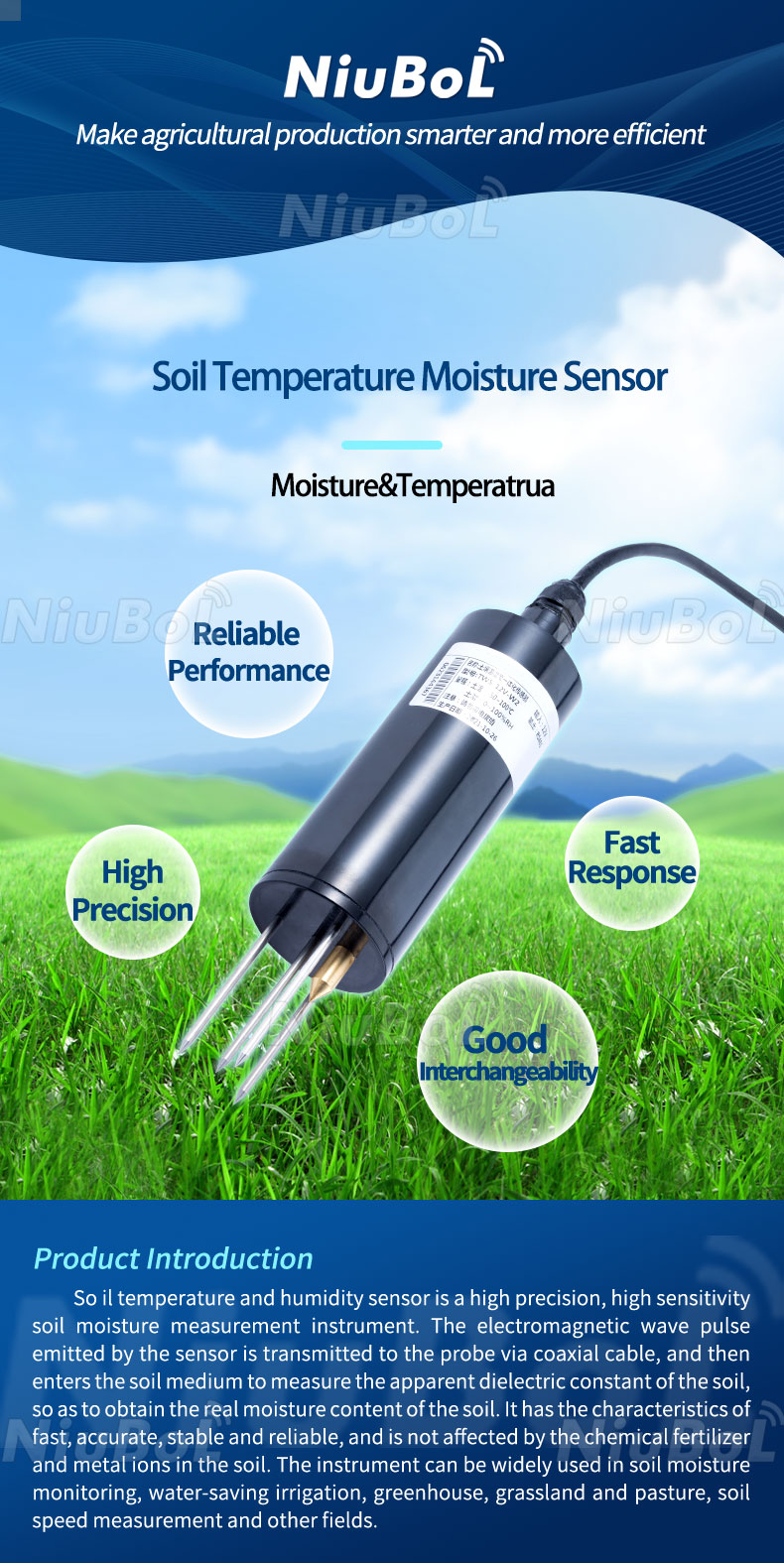
| Soil Temperature Moisture Sensor | NBL-S-THR soil temperature moisture sensor for soil water content and soil temperature | Irrigation control and crop root-zone analysis |
| Solar Radiation or Illuminance | Radiation or light intensity | Crop growth and evapotranspiration reference |
| Data Logger / Gateway | Local collection and remote upload | Cloud platform and SCADA connection |
| Solar Power Supply | Off-grid power | Remote field deployment |
For open-field farms, the station can support irrigation scheduling, drought analysis, wind-risk warnings for spraying operations, rainfall records, and local climate archives. For high-value crop bases, it can help compare different field blocks and support precision agriculture decisions.
For rural meteorological service projects, multiple monitoring points can be deployed across production areas, living areas, transport corridors, forestry areas, and ecological zones. The network improves local weather service capability and supports emergency plans for storm, snow, drought, and other agricultural disasters.
Start with the decision problem. If the project focuses on irrigation, soil moisture and rainfall are essential. If it focuses on crop disease risk, temperature, humidity, rainfall, and leaf wetness or radiation may be required. If it focuses on disaster prevention, wind speed, wind direction, rainfall intensity, pressure, and communication reliability become more important.
Procurement teams should confirm the number of monitoring points, communication coverage, solar exposure, mounting height, soil sensor depth, data platform access, maintenance route, and whether the project needs local display, remote alarm, or API integration.

Good agricultural data depends on representative installation. Avoid locations that are blocked by buildings, trees, irrigation equipment, or field edges unless the monitoring objective specifically requires those micro-zones. Soil sensors should be installed at depths matching crop root distribution and irrigation management zones.
For platform integration, define data names, units, sampling interval, alarm thresholds, and data export format in advance. Agricultural managers and contractors should agree on how meteorological events trigger actions such as irrigation adjustment, drainage inspection, field operation suspension, or emergency notification.
A farmland microclimate project should be designed around monitoring zones rather than single devices. Different fields may have different soil texture, irrigation source, crop variety, slope, shelter, and wind exposure. The monitoring network should represent these differences so the data can support real management decisions.
A useful network may combine NBL-W-10GUWS ultrasonic weather station data with NBL-S-THR soil temperature moisture sensor data. Weather data explains atmospheric demand and rainfall conditions, while soil data shows whether the crop root zone actually needs irrigation or drainage.
For project delivery, each station should have a site code, coordinate record, sensor depth record, power supply record, and platform tag. This helps farm managers compare blocks and helps contractors maintain the system during the growing season.
Acceptance should not stop at checking whether data appears on the screen. The contractor should verify representative sensor placement, rainfall response, soil sensor depth, gateway signal, solar charging condition, offline alarm, historical curve, and exportable records.
The final system should help agricultural managers answer practical questions: which block is dry, which area received rain, whether spraying is suitable under current wind conditions, and whether a weather event requires field inspection.
A farmland project can be organized into primary stations and auxiliary soil points. A primary station records weather variables such as wind, rainfall, temperature, humidity, pressure, and optional radiation. Soil points are placed in representative crop zones to capture root-zone moisture and temperature. This layout gives managers both atmospheric data and crop-zone response data.
For a large planting base, one station may be placed in an open central area while additional soil sensors are installed in different irrigation zones. If the field has slopes, different soil types, or separated crop varieties, the monitoring plan should reflect those differences instead of placing all sensors near the equipment room.
The platform should allow each monitoring point to be named by field block, crop type, or irrigation zone. Practical naming is more useful than only using device serial numbers because farm managers need to read the dashboard quickly during irrigation or weather-risk decisions.
Wind speed and wind direction can support decisions about spraying windows and field operation safety. Rainfall data helps determine whether irrigation can be delayed. Temperature and humidity records support disease-risk observation, frost response, and greenhouse-perimeter comparison. Soil moisture data shows whether rainfall actually entered the root zone.
When these parameters are combined, the station becomes more than a weather display. It becomes an operational reference for irrigation, inspection scheduling, crop protection, and agricultural service reporting.
Agricultural monitoring should be reviewed by season. In early growth stages, soil moisture thresholds may be conservative. During high water-demand periods, irrigation rules may need to change. After harvest, the station may still support soil management, equipment maintenance, or climate archive records.
Contractors should help owners establish a basic data review routine. Weekly review can focus on missing data, abnormal spikes, low battery events, rainfall records, and irrigation response. Seasonal review can compare crop performance with weather and soil records.
This long-term data habit improves the value of the monitoring network and helps justify future expansion to additional fields, greenhouses, reservoirs, or livestock areas.
In a multi-block farm, the monitoring station can support a local agricultural service center. Weather data helps service staff decide when to issue field operation reminders, while soil data helps identify plots that need irrigation inspection. The system can also provide records for crop management reports and technical service summaries.
For contractors, this use case requires a dashboard that is easy to read by non-technical managers. Site names, block labels, alarm colors, and historical curves should be organized around farm operations rather than device numbers alone.
If the project includes government or cooperative service requirements, exported records should include monitoring time, station name, parameter units, and abnormal-event notes. This makes the data easier to use in seasonal review and service documentation.
Farmland sites often face power interruption, weak signal coverage, irrigation spray, machinery movement, and seasonal vegetation changes. These risks should be considered during installation instead of being treated as maintenance problems later.
Sensor poles should be protected from machinery routes, and soil sensor cable routes should be marked or buried properly. If a gateway depends on mobile communication, the signal should be tested during the site survey and again after installation.
The monitoring network should also include a data health check. Missing data, flat curves, sudden jumps, and repeated offline events should be visible to the service team so problems can be handled before the owner loses trust in the system.
For farms with multiple managers or service teams, permission and reporting workflows should also be considered. A field technician may need real-time alarms, while the owner may need monthly summaries, exported data, and seasonal comparison charts.
Regional forecasts describe a broad area, while farmland management often depends on field-level conditions. Different blocks can have different wind exposure, soil moisture, rainfall, temperature, and humidity. A farmland microclimate monitoring station provides localized data for irrigation, field inspection, crop protection, and agricultural service records.
Monitoring points should represent differences in crop type, soil texture, irrigation zone, terrain, and management priority. A central weather station can provide atmospheric data, while soil sensors can be installed in representative root zones. The layout should help managers compare blocks and make field decisions, not simply place devices where installation is convenient.
NBL-W-10GUWS ultrasonic weather station provides weather context such as wind, rainfall, temperature, humidity, and pressure. NBL-S-THR soil temperature moisture sensor shows root-zone soil response. Together, they help determine whether rainfall reached the crop root zone, whether irrigation is needed, and whether field conditions support crop operation decisions.
A useful platform should show station name, field block, live data, historical curves, rainfall records, soil moisture trend, alarm status, and exportable reports. Managers need operational information, not only raw device values. Clear labels and consistent units help the system support daily farm decisions.
Rainfall, wind, temperature, humidity, and soil moisture data can support drought response, storm inspection, frost warning, drainage planning, and field operation suspension. The value comes from combining local monitoring records with predefined action rules so managers know when to inspect, irrigate, drain, or delay field work.
Common risks include weak communication signal, unstable solar power, machinery damage, irrigation spray, vegetation blocking, poor cable protection, and unrepresentative sensor placement. These risks should be addressed during site survey and installation. A data health check can help identify missing data, abnormal flat lines, and repeated offline events.
Acceptance should include station location records, sensor depth records, installation photos, gateway signal status, power condition, live data screenshots, historical curve verification, alarm test, and exported sample data. These records help both the contractor and owner confirm that the system is ready for operation.
Yes. If the first deployment uses standard RS485 MODBUS sensors, clear station naming, and consistent platform fields, additional weather stations, soil sensors, irrigation controllers, or greenhouse monitoring points can be added later with less redesign.
A farmland microclimate weather monitoring station is most valuable when it is designed as an integrated agricultural data system. With NiuBoL sensors, RS485 MODBUS compatibility, soil and weather parameter options, and scalable communication architecture, integrators can build practical monitoring networks for smart agriculture, irrigation optimization, and agricultural disaster prevention.
Related recommendations
Sensors & Weather Stations Catalog
 Agriculture Sensors and Weather Stations Catalog-NiuBoL.pdf
Weather Stations Catalog-NiuBoL.pdf
Agriculture Sensors Catalog-NiuBoL.pdf
Water Quality Sensor Catalog-NiuBoL.pdf
Related products
 Combined air temperature and relative humidity sensor Soil Moisture Temperature sensor for irrigation|NBL-S-THR
 Soil pH sensor RS485 soil Testing instrument soil ph meter for agriculture |NBL-S-PH
 Wind Speed sensor Output Modbus/RS485/Analog/0-5V/4-20mA
 Tipping bucket rain gauge for weather monitoring auto rainfall sensor RS485/Outdoor/stainless steel
 Pyranometer Solar Radiation Sensor 4-20mA/RS485

Screenshot, WhatsApp to identify the QR code
WhatsApp number:+8615367865107
(Click on WhatsApp to copy and add friends)
