


— Blogs —
—Products—
 Consumer hotline +8618073152920
 WhatsApp:+8615367865107
Address:Room 102, District D, Houhu Industrial Park, Yuelu District, Changsha City, Hunan Province, China
Product knowledge
Time:2026-06-23 11:28:40 Popularity:17
Autumn and winter are important forest fire prevention periods in many regions. Dry air, low rainfall, wind, combustible vegetation and human activity can increase fire risk. A forest fire weather station provides continuous observation of meteorological factors that influence ignition probability, fire spread direction and response planning.
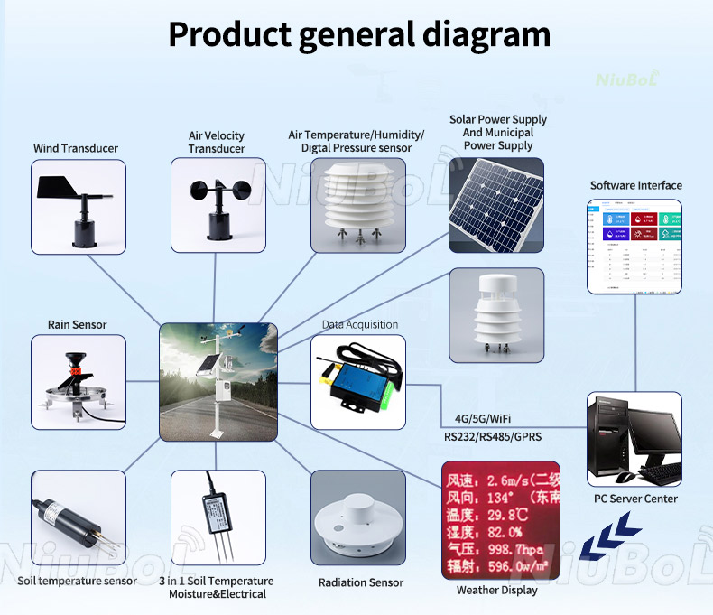
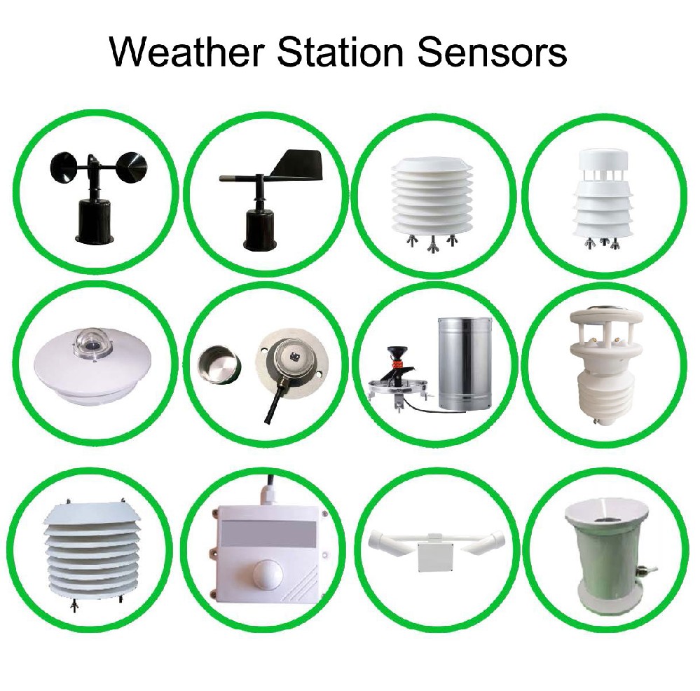
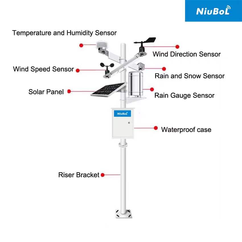
NiuBoL forest weather stations are designed for unattended outdoor operation. They can monitor rainfall, air temperature, air humidity, light intensity, soil temperature, soil moisture, evaporation, atmospheric pressure, wind speed, wind direction and other factors according to the project. Data can be uploaded through a communication module to a monitoring platform for remote review.
Forest fire prevention requires early information. When temperature rises, humidity decreases, rainfall is absent and wind speed increases, fire risk can change quickly. If a fire occurs, wind direction and wind speed become important for response teams because they influence the possible spread direction. A forest weather station supports both prevention and incident review.
From a procurement perspective, the station should be designed as a field system. It includes sensors, collector, power supply, protective box, communication module, mounting structure and cloud platform. Because forest sites are remote, low power consumption, lightning protection, anti-interference design and maintainable installation are important.
| Parameter | Reference Value | Procurement Note |
|---|---|---|
| Air temperature | Tracks heat conditions related to dry fuel risk | High temperature periods need closer fire watch |
| Air humidity | Low humidity increases drying of combustible material | Useful for warning thresholds |
| Rainfall | Records precipitation and dry periods | No-rain intervals help interpret fire risk |
| Wind speed and direction | Indicates fire spread potential and smoke movement | Important for emergency response planning |
| Light intensity | Supports local radiation and exposure interpretation | Helps explain drying conditions |
| Soil temperature and moisture | Reflects ground moisture and ecological condition | Useful for long-term forest environment records |
| Evaporation | Supports drought and moisture loss evaluation | Useful in dry-season monitoring |
| Atmospheric pressure | Adds weather trend context | Useful for meteorological analysis |
| Communication | 4G or other project communication with platform upload | Confirm network coverage in forest site |
Forest station integration should begin with site survey. The project team should confirm terrain, trees, open exposure, solar condition, mobile network signal, maintenance path, pole foundation and lightning protection. Sensors may use RS485 / Modbus to connect to a collector, while the station host uploads data through 4G or another communication method.
Acceptance should include sensor readings, platform display, upload interval, alarm threshold, solar charging, battery status, communication recovery and physical stability. A site file should record coordinates, photos, sensor height, pole installation and power configuration.
Site challenge: Large forest areas need continuous weather risk data during dry seasons.
System integration scheme: Install stations in representative ridges, valleys or management zones with platform alarms.
User value: Managers can review local fire weather conditions without relying only on distant stations.
Site challenge: Tourism activity and dry vegetation increase prevention pressure.
System integration scheme: Use weather stations near sensitive zones and combine data with patrol plans.
User value: Operators can improve patrol timing and public warning decisions.
Site challenge: Multiple forest zones need comparable data and remote access.
System integration scheme: Deploy standardized station configurations with unified platform naming.
User value: Regional managers can compare risk conditions across stations.
Site challenge: When fire occurs, wind speed and direction influence spread and smoke.
System integration scheme: Use real-time station data to support local response assessment.
User value: Response teams gain weather context close to the incident area.
Site challenge: Long-term forest climate data supports fire ecology and drought studies.
System integration scheme: Use exportable records, clear metadata and stable sensor maintenance.
User value: Researchers can connect weather patterns with vegetation and fire-risk trends.
A forest fire weather station should not be treated as a normal weather display. Its purpose is to help forestry managers understand the conditions that make ignition and spread more likely. Temperature, humidity, rainfall, wind speed, wind direction, radiation and soil moisture should be interpreted together rather than as isolated readings.
During autumn and winter prevention periods, dry air and long no-rain intervals may increase fuel dryness. Wind speed and direction become especially important when a fire starts because they influence spread direction and smoke movement. A station close to the forest management area provides more useful evidence than a distant city weather report.
For a single scenic area, one station may be enough for a key entrance, ridge or high-risk area. For a forestry bureau or large reserve, several stations may be needed across elevation, vegetation and exposure zones. The platform should make station comparison easy and should keep historical records for seasonal risk review.
Remote forest stations need careful power and communication planning. Solar exposure, battery autonomy, lightning protection, pole stability and maintenance access should be confirmed during site survey. If mobile signal is weak, the project must solve communication before installation rather than after the equipment arrives.
Forest fire weather monitoring should focus on combinations of risk indicators. Low humidity after several rainless days is more meaningful than one dry reading. Strong wind after a dry period is more important than wind alone. High temperature with low humidity and high radiation can indicate faster drying of combustible material.
The station should therefore support historical trend review. Managers need to see whether the forest has been drying for days, not only whether the current humidity is low. This is why data storage and chart functions are valuable in fire prevention work.
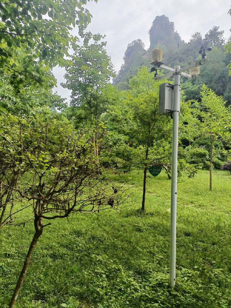
A scenic area may place a station near a ridge, entrance, viewing platform or historically high-risk zone. The aim is to support patrol scheduling and tourist safety communication.
A large forest should use several stations across representative microclimates. Elevation, valley/ridge exposure, vegetation type and access route can all affect data. The platform should allow comparison between stations so managers can identify the driest or windiest zone.
The station data should be connected with patrol plans, warning rules and incident records. If a high-risk threshold is reached, the response may be more patrols, stricter fire-source control, public notices or equipment readiness. Without a defined workflow, even accurate weather data may not change field action.
Forest fire prevention work benefits from records that can be reviewed after a dry season. The station should keep historical curves for humidity, rainfall, temperature and wind, and the management team should record patrol actions or warning decisions made during high-risk periods.
This record helps the owner improve the next season's fire prevention plan. If a certain zone repeatedly shows low humidity and strong wind, patrol resources can be adjusted. If a station loses communication during a critical period, the power and network design can be improved before the next season.
For emergency use, the station should be easy to identify on the platform map. Station names should match local management zones, not only equipment serial numbers. This makes data faster to use when field teams are under pressure.
Before the fire prevention season, the station should be inspected for battery health, solar charging, sensor cleanliness and communication status. Alarm thresholds should be reviewed before the dry period begins, not during an emergency.
During the prevention season, managers should review humidity, wind and rainfall trends together with patrol records. After the season, exported data can help identify which locations had repeated high-risk weather, where station coverage should be improved and whether maintenance response was fast enough.
This seasonal workflow makes the forest weather station part of a prevention system rather than a standalone instrument. It also creates a data record that can support budget planning for additional stations or maintenance in the next year.
For procurement teams, the final decision should connect station density with management responsibility. A lower-cost single station may be enough for one entrance area, while a reserve with different elevations often needs several nodes to avoid blind spots.
For procurement teams, the final decision should connect station density with management responsibility. A lower-cost single station may be enough for one entrance area, while a reserve with different elevations often needs several nodes to avoid blind spots. This also helps justify future expansion when the first season of data shows uneven fire-weather risk across the forest area.
A: It continuously monitors weather factors related to fire risk, including temperature, humidity, rainfall, wind speed, wind direction and other environmental data near forest areas.
A: Air humidity, temperature, rainfall history, wind speed and wind direction are usually the most important. Soil moisture, radiation and evaporation can provide additional dryness context.
A: Wind speed indicates spread potential, while wind direction helps estimate where fire or smoke may move. This information supports patrol, warning and response planning.
A: No. It provides environmental risk evidence. Fire prevention decisions should also consider vegetation dryness, human activity, terrain, patrol reports and local fire management rules.
A: Choose a representative and maintainable location with acceptable exposure, solar charging conditions, communication signal and physical security. Avoid locations blocked by dense trees when wind or radiation data is important.

A: Many forest projects use 4G or other wireless upload from the station host. Field sensors may connect to the collector through RS485 / Modbus. Network coverage must be checked before procurement.
A: Include sensor list, wiring diagram, platform account, coordinates, installation photos, pole height, power configuration, communication settings and maintenance schedule.
A: Thresholds should reflect local climate and management rules. A useful alarm may combine low humidity, high wind, no recent rainfall and high temperature rather than relying on one parameter.
A: Verify sensor readings, upload interval, platform display, historical storage, alarm rules, solar charging, battery status, pole stability and communication recovery after interruption.
A: Inspect the solar panel, battery, pole, enclosure, cables, sensor surfaces and communication status regularly, especially before and during the main fire prevention season.
A forest fire weather station supports prevention by continuously recording the weather factors that influence ignition and spread risk. For autumn and winter fire prevention, buyers should focus on sensor configuration, representative installation, reliable power, communication coverage and useful platform alarms. A well-documented station can support daily prevention, emergency response and long-term forest management.
Related recommendations
Sensors & Weather Stations Catalog
 Agriculture Sensors and Weather Stations Catalog-NiuBoL.pdf
Weather Stations Catalog-NiuBoL.pdf
Agriculture Sensors Catalog-NiuBoL.pdf
Water Quality Sensor Catalog-NiuBoL.pdf
Related products
 Combined air temperature and relative humidity sensor
 Soil Moisture Temperature sensor for irrigation|NBL-S-THR
 Soil pH sensor RS485 soil Testing instrument soil ph meter for agriculture |NBL-S-PH
 Wind Speed sensor Output Modbus/RS485/Analog/0-5V/4-20mA
 Tipping bucket rain gauge for weather monitoring auto rainfall sensor RS485/Outdoor/stainless steel
 Pyranometer Solar Radiation Sensor 4-20mA/RS485

Screenshot, WhatsApp to identify the QR code
WhatsApp number:+8615367865107
(Click on WhatsApp to copy and add friends)
