


— Blogs —
—Products—
 Consumer hotline +8618073152920
 WhatsApp:+8615367865107
Address:Room 102, District D, Houhu Industrial Park, Yuelu District, Changsha City, Hunan Province, China
Product knowledge
Time:2026-02-14 16:31:09 Popularity:374
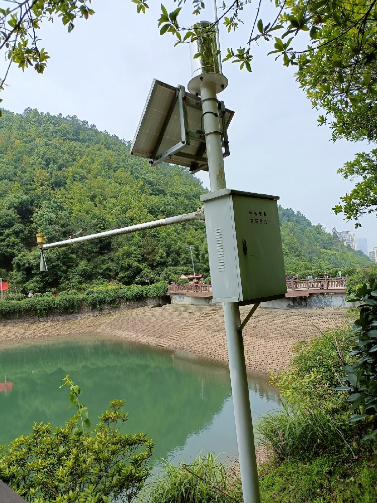
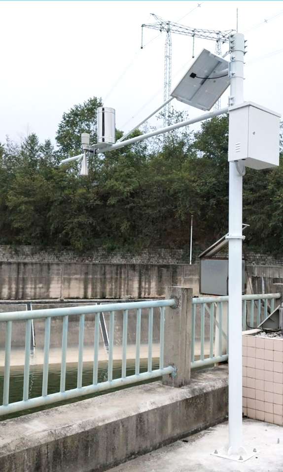
In smart water conservancy, flood control and drought relief, water resource scheduling, and river/lake chief monitoring systems, automatic radar water level monitoring stations have become core equipment for system integrators, IoT solution providers, project contractors, and engineering companies to deploy hydrological monitoring networks. These stations utilize 77–79 GHz FMCW (Frequency Modulated Continuous Wave) radar technology to achieve non-contact high-precision water level measurement, supporting RS485/MODBUS RTU protocol and 4G/5G wireless transmission for seamless integration with water conservancy SCADA systems, hydrological telemetry platforms, or cloud-based water regime forecasting models.
As a professional manufacturer, NiuBoL provides millimeter-level precision automatic radar water level monitoring stations tailored to complex hydrological conditions in rivers, lakes, reservoirs, and channels, helping engineering projects transition from traditional contact-based measurement to stable, maintenance-free digital monitoring, improving real-time performance and reliability of water level data.

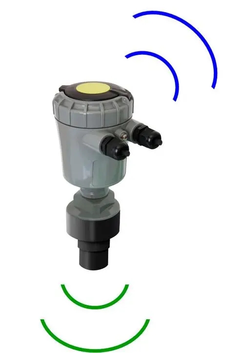
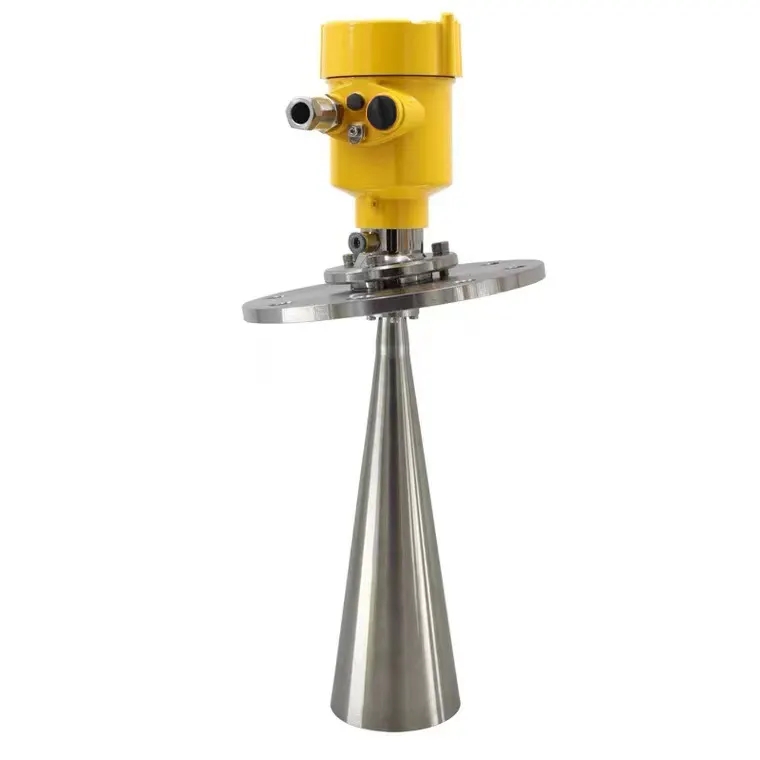
The NiuBoL automatic radar water level monitoring station is based on self-developed CMOS millimeter-wave RF chips and FMCW principle. It transmits 77–79 GHz microwave signals toward the water surface, receives reflected echoes, and precisely calculates the distance from the device installation elevation to the water surface by measuring the round-trip time difference (combined with the constant speed of light). The water level calculation formula is: Actual water level elevation = Device installation elevation – Radar-to-water-surface distance. This technology achieves a maximum range of 65 m, blind zone<15 cm, resolution 1 mm, and accuracy ±1 mm (typical conditions: 4 m distance, 40% RH, 25℃).
The device features an integrated lens antenna design with a beam angle of only 8°, effectively suppressing sidelobe interference and false echoes. Power consumption is as low as 0.6 W, supporting DC 10–30 V power supply, typically paired with solar + battery for long-term off-grid operation. It integrates a data collector, RS485 output, and optional 4G/5G module, supporting local storage and remote transmission. Non-contact measurement avoids impacts from sediment, floating debris, corrosion, or icing, making it suitable for high-sediment rivers, tidal zones, and extreme weather environments.
Main functions include:
All-weather continuous monitoring: Unaffected by light, wind, rain, fog, or haze.
High-resolution output: 1 mm resolution with wave filtering algorithm to suppress noise from water surface fluctuations.
Low-maintenance design: IP67 protection rating, operating range -40℃ to +80℃, resistant to temperature and humidity changes.
Data compatibility: Standard MODBUS RTU protocol for easy integration with PLC, RTU, or cloud platforms.
The following table summarizes the key technical specifications of the NiuBoL automatic radar water level monitoring station:
| Parameter | Specification / Range | Accuracy / Remarks |
|---|---|---|
| Transmit Frequency | 77 GHz – 79 GHz | FMCW frequency modulated continuous wave |
| Measurement Range | 0.15 m – 65 m | Blind zone<15 cm |
| Resolution | 1 mm | - |
| Measurement Accuracy | ±1 mm (4 m, 40% RH, 25℃) | Typical conditions |
| Beam Angle | 8° | Narrowest beam, reduced interference |
| Supply Voltage | DC 10–30 V | Typical power consumption 0.6 W |
| Operating Temperature | -40℃ – +80℃ | Full operating conditions |
| Operating Humidity | 0% – 95% RH (non-condensing) | - |
| Protection Rating | IP67 | Waterproof and dustproof |
| Communication Interface | RS485 | MODBUS RTU protocol |
| Antenna Design | Integrated lens | Compact size, easy installation |
These specifications ensure high-reliability data provision in water conservancy projects, supporting remote firmware upgrades and parameter configuration.
When building hydrological telemetry networks or smart water conservancy platforms, system integrators typically use NiuBoL automatic radar water level monitoring stations as the front-end perception layer for water level, deeply integrated with upper-level water regime forecasting systems. Typical solutions include:
1. Real-time Water Level Acquisition and Early Warning: RS485 output connects to RTU or edge gateway; water level data read via MODBUS RTU. Integrators can access Ministry of Water Resources telemetry protocol or custom MQTT push to cloud platforms for minute-level reporting. When water level exceeds warning threshold, automatic SMS/voice/APP push is triggered, supporting linkage with gate/dam control systems (e.g., automatic gate opening for flood discharge).
2. Distributed River and Lake Monitoring Network: Deploy multiple nodes at river cross-sections, lakes, reservoir upstream/downstream, and key channel points (spacing depending on river width and terrain, typically one station every 5–20 km). RS485 bus or 4G/LoRaWAN networking supports expansion to hundreds of nodes. Aggregated data accesses provincial hydrological platforms or national hydrological databases with low-latency transmission.
3. Compatibility with Existing SCADA/Telemetry Systems: Standard MODBUS RTU protocol compatible with Siemens, Schneider, or domestic RTUs; RS485-to-TCP gateways enable integration with water conservancy SCADA systems. IoT solution providers can standardize water level data into JSON format, fusing with rainfall, flow, and video surveillance to form comprehensive water regime models supporting flood forecasting and drought assessment.
4. Solar Off-Grid Deployment: In remote river sections or areas without mains power, pair with solar panels + lithium battery packs to ensure continuous operation >7 days without sunlight. Integrators can add wave filtering algorithms and temperature compensation to further improve data quality.
This solution emphasizes non-contact, low-maintenance, and high-compatibility features, helping engineering companies reduce on-site inspection frequency, improve data continuity, and enhance flood response speed.
When selecting equipment, system integrators should evaluate based on monitoring object, environmental conditions, and integration requirements:
High-sediment rivers/channels: Prioritize narrow-beam (8°) models with strong anti-interference algorithms; 30–65 m range suitable for wide channels.
Reservoirs/lakes large-area monitoring: Select long-range (>50 m) configurations with wave filtering; blind zone<15 cm suitable for near-shore installation.
Tidal/coastal areas: Integrate humidity compensation and anti-corrosion design to handle salt fog corrosion.
Communication and Power Supply: Choose LoRaWAN + solar for remote areas without coverage; prefer RS485 + 4G module where 4G signal is available.
Accuracy and Scalability: For high flood warning requirements, select ±1 mm precision devices; reserve interfaces for future integration of flow or water quality sensors. Recommend on-site POC testing to verify beam clearance and data stability. MTBF typically >50,000 hours.
Installation Location: Device must be installed perpendicular to the water surface; tilting weakens echo strength. Avoid interference objects (riverbanks, piers, vegetation, buoys) within the beam range; recommend distance to obstacles >3× range.
Installation Height and Fixing: Nut-fixed method with hydrological poles or main unit; installation elevation must be precisely measured and recorded as the baseline for water level calculation.
Power Supply and Lightning Protection: DC 10–30 V isolated power + SPD lightning protection module; solar system battery capacity supports 7 days of continuous cloudy/rainy weather.
Data Calibration and Maintenance: Perform zero-point calibration after initial deployment; verify accuracy every 6–12 months and clean lens surface. Avoid strong electromagnetic interference sources.
Beam Optimization: Narrowest 8° beam reduces sidelobe interference; conduct on-site survey before installation to ensure no false echoes.

1. How does the automatic radar water level monitoring station achieve high-precision measurement?
Based on 77 GHz FMCW technology, combined with large bandwidth and narrow-beam algorithms, achieving ±1 mm accuracy and 1 mm resolution, with wave filtering support.
2. How stable is the device in high-sediment or wavy environments?
Non-contact measurement is unaffected by sediment or floating debris; built-in DSP algorithm suppresses wave noise, with stable data performance during flood seasons with waves.
3. Which communication protocols and platform integrations are supported?
RS485/MODBUS RTU standard output, compatible with hydrological telemetry platforms, SCADA systems, and MQTT cloud access.
4. Can solar power ensure continuous operation?
Yes — average power consumption 0.6 W, paired with appropriate solar + battery pack, supports continuous operation for more than 7 days without sunlight.
5. What are the main installation considerations?
Perpendicular to water surface, no beam interference objects; precise measurement of installation elevation to avoid false echoes.
6. How is long-term data accuracy ensured?
Built-in temperature compensation + periodic calibration; ±1 mm accuracy specification ensures reliability across -40 ~ +80℃ full operating conditions.
7. Which hydrological monitoring scenarios are applicable?
Rivers, lakes, reservoirs, channels, flood warning; customized configurations for high-sediment, tidal, and remote areas.
8. What is the warranty and after-sales service mechanism?
Standard 12-month warranty; remote diagnostics, 48-hour response, on-site support and technical training when necessary.
With 77 GHz FMCW high-precision non-contact technology and low-maintenance design as the core, the NiuBoL automatic radar water level monitoring station provides system integrators with a reliable water level perception solution. Through seamless integration, real-time data transmission, and adaptation to complex conditions, these devices help engineering projects improve water regime monitoring accuracy, strengthen flood control capabilities, and optimize water resource scheduling. Whether for large reservoir dam monitoring or remote river telemetry networks, NiuBoL is committed to delivering stable and precise hydrological data to support the digital transformation of water conservancy. Welcome to submit project requirements via email or online form; we will provide selection advice and technical solutions within 24 hours.
Related recommendations
Sensors & Weather Stations Catalog
 Agriculture Sensors and Weather Stations Catalog-NiuBoL.pdf
Weather Stations Catalog-NiuBoL.pdf
Agriculture Sensors Catalog-NiuBoL.pdf
Water Quality Sensor Catalog-NiuBoL.pdf
Related products
 Combined air temperature and relative humidity sensor
 Soil Moisture Temperature sensor for irrigation|NBL-S-THR
 Soil pH sensor RS485 soil Testing instrument soil ph meter for agriculture |NBL-S-PH
 Wind Speed sensor Output Modbus/RS485/Analog/0-5V/4-20mA
 Tipping bucket rain gauge for weather monitoring auto rainfall sensor RS485/Outdoor/stainless steel
 Pyranometer Solar Radiation Sensor 4-20mA/RS485

Screenshot, WhatsApp to identify the QR code
WhatsApp number:+8615367865107
(Click on WhatsApp to copy and add friends)
