





— Blogs —
—Products—
 Consumer hotline +8618073152920
WhatsApp:+8615367865107
Address:Room 102, District D, Houhu Industrial Park, Yuelu District, Changsha City, Hunan Province, China
Product knowledge
Time:2024-05-05 19:52:14 Popularity:1788
Quick Answer: Weather stations for agricultural insurance can supply local, time-stamped observations for an agreed insurance method. They do not determine premiums, prove crop damage or authorize compensation by themselves. Specify the insured weather variable, station reference, observation period and data-quality rules before selecting equipment. A NiuBoL station can provide the measurement layer; acceptance of its records depends on the project's insurance and data arrangements.

Local weather records may support index design, exposure analysis, event reconstruction and farmer risk services. Rainfall, air temperature, humidity, wind and solar radiation are selected according to the covered peril and crop. Soil measurements may support agronomic context, but they are strongly affected by installation depth, soil type and field management.
An insurer can combine station records with official meteorological data, remote sensing, field inspection and policy terms. The station record is one evidence layer. It should not be presented as an automatic claims decision.
In weather index insurance, an agreed calculation uses a specified indicator rather than directly measuring every farm's loss. A rainfall index may depend on accumulated rain, the timing of rain or a defined sequence of dry days. Those calculations need different records. A seasonal total cannot reconstruct the sequence if the daily observations have not been retained.
For a loss investigation, station data may help describe an event alongside crop inspection and other information. The record still describes a location and exposure, not every affected field. A crop may suffer a loss even where the chosen index does not trigger, or an index may trigger without the same loss at every farm.
This mismatch is called basis risk. The World Bank's study of reliable index-insurance protection discusses why the relationship between a trigger and actual losses matters. More precise hardware can reduce measurement error, but it cannot by itself remove differences between the reference observation and the insured crop's experience.
| Index or investigation need | Observation to define | Common mismatch |
|---|---|---|
| Accumulated rainfall | Collector, units, start and end times, reset behavior | A total since startup used as a policy-period total |
| Dry-day sequence | Daily boundary, valid rainfall record and the agreed dry-day definition | Missing rain data counted as a dry day |
| Heat or cold exposure | Shielded temperature, observation interval and required statistic | A daily mean used where duration or an extreme is needed |
| Wind event | Exposure, measurement height and specified averaging or gust method | One uploaded sample described as the event's maximum gust |
| Supporting crop context | Field position, crop stage and any additional soil observations | A soil reading treated as direct evidence of atmospheric drought |
Keep the observation method consistent with the reference record used to design the insurance product. Moving from one sensor height, rainfall method or aggregation interval to another can change comparability. Identify the change and its effective date; do not silently join the series as though the measurement conditions had remained identical.
Agree how competing sources will be handled before an event. A field station, an official station and a gridded estimate may observe different conditions and use different methods. Choosing whichever value produces a preferred result after the event is not a data-quality procedure. The insurance arrangement should identify approved sources and any fallback method.

For a project using local rainfall and air conditions, NiuBoL can configure separate instruments rather than assigning one generic station accuracy. The following examples show component limits that must be considered when agreeing the observation method. They do not establish acceptance for a particular insurance contract.
| Instrument option | Relevant specification | What the project must resolve |
|---|---|---|
| NBL-W-RS, 0.2 mm rain-gauge version | 0.2 mm per tip; intensity 0-4 mm/min; +/-4% in an indoor static test at 2 mm/min | Collector exposure, leveling, counting and the permitted evaluation conditions |
| NBL-W-RS environment and connection | Working temperature 0-50 C; pulse, voltage or RS485 version; 5 m standard cable | Liquid-rainfall scope, compatible input and cable routing; not a snow measurement configuration |
| NBL-W-LBTH air temperature | -40 to 80 C; +/-0.5 C; 0.1 C resolution | Shield, height, exposure and the required time statistic |
| NBL-W-LBTH relative humidity | 0-100% RH; +/-5% RH; 0.1% RH resolution | Whether RH is an index input or only supporting context |
| NBL-W-LBTH supply and output | 12-24 V DC; RS485 or 4-20 mA version | Logger inputs and scaling for the ordered version |
| Station power and protection | Configured from sensors, logger, communication and site conditions | Whole-system consumption, enclosure rating, cable jacket and usable battery energy |
Do not select an instrument solely because its displayed resolution is smaller than the index threshold. Resolution, measurement error, field exposure and missing records all affect the result. Where an insurance calculation uses wind observations, select the wind instruments and their exposure separately; NBL-W-SS and NBL-W-DS housing protection for these projects is IP65.
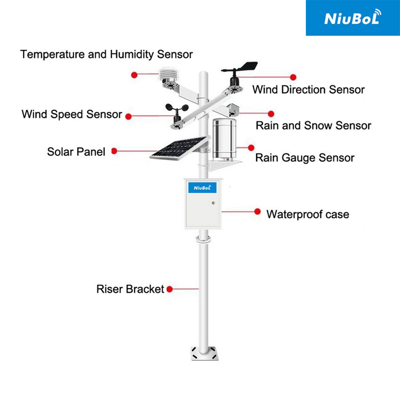
The NiuBoL weather-station range includes configurable assemblies, but the number of sensors pictured does not define what an insurance project requires. A temperature-only index does not automatically need every available channel. Add measurements when they serve the agreed calculation or a clearly defined supporting task.
| Control | Why it matters | Required record |
|---|---|---|
| Site representation | Weather can vary across terrain and production zones. | Coordinates, elevation, exposure, photographs and siting rationale |
| Measurement method | Sensor type and height affect comparability. | Model, serial number, units, mounting and calibration status |
| Time integrity | Event analysis depends on aligned timestamps. | Time zone, synchronization source and sampling interval |
| Data custody | Claims evidence must be traceable. | Access control, change log, backup and retention policy |
| Outage handling | Communication loss must not silently erase evidence. | Local storage, retransmission rule and missing-data flag |
As a data-check example, a UTC day recorded at five-minute intervals has 288 expected observation slots. A file containing 288 rows can still have one duplicated timestamp and one missing slot. Count valid unique intervals, not just rows. This is a completeness example, not a universal reporting interval or an insurance acceptance rule.
Retain sensor acquisition time when recovering records after a communication outage. An upload timestamp cannot reconstruct the event if earlier values are all assigned the time they arrived at the server. Also distinguish a failed sensor from a working logger: local storage protects against lost transmission only if valid observations were actually acquired.
Preserve the original record when a correction is needed. Store the reason, author, time and method of the correction, and keep the unmodified series available under controlled access. A change log helps trace an adjustment; it should not be described as proof that all data are authentic or impossible to alter.
Station spacing should follow the insured peril, terrain and product method. A dense rainfall network may be required where convective storms vary over short distances, while temperature-index products may use a different design. The insurer, agronomist and measurement specialist should agree the network before equipment is ordered.
For RS485 Modbus RTU sensors, the logger must support the register maps, channel count and power budget. Remote communication may use the available cellular or other network, with local storage sized for outages. The RFQ should state sensors, measurement ranges, output, enclosure, solar power, mounting, surge protection, commissioning, calibration documents, platform or API scope, spares and support.
Test one complete path from a known measurement to the exported record. Confirm station identity, location, units, sensor scaling and the daily boundary. Introduce a controlled communication interruption and verify that the restored records retain their acquisition times. Check that a restart does not silently reset rainfall or change the configuration used for aggregation.
For agricultural risk monitoring, inspect whether the proposed site represents the intended exposure. A shaded point, roof edge, sheltered valley or irrigated patch may differ from the reference conditions. Retain installation photographs and review them after vegetation growth, building work or sensor replacement. Moving a station for easier access can change the meaning of its series.
Identify who maintains the instruments, approves changes, reviews gaps and releases a data extract for the insurance calculation. Include replacement procedures so that a failed probe can be exchanged without losing its identity or calibration history. Keep operational alarms distinct from a final accepted index record: prompt warning data may still need review.
A weather reading can confirm what one instrument recorded at one location. It cannot alone establish crop damage, policy coverage, cause or loss amount. Claims handling should use the contract's evidence rules and qualified assessment. Likewise, unusual data is a reason for review, not proof of fraud.
For a NiuBoL project discussion, provide the target weather variable, required interval, reference exposure, receiving format and approved outage policy. State whether the station is a designated index source or an additional investigation point. Hardware can then be selected for that role without assuming that buying a station establishes eligibility or changes the insurance terms.
It can be an input where the insurance terms designate the source, variable, period, quality requirements and calculation. Equipment capability alone does not establish those terms or authorize a payment.
It may improve the observation of local differences, but does not remove all mismatch between an index and crop loss. Crop stage, exposure and the chosen trigger also matter. Evaluate the network and index together before procurement.
No. Zero rainfall is a valid observation; missing data indicate that the observation is unavailable. Apply the agreed quality and fallback procedure rather than automatically turning a gap into a dry day.
Not automatically. The insurance method should define which sources are used, their roles and how differences are resolved. A nearby instrument is not accepted simply because it has a more detailed display.
The required measurements, station count, exposure, acquisition interval, local storage, power and communication determine the configuration. Ask for those items separately from data services and maintenance. The equipment quotation is not an insurance premium quotation.
Verify the model, serial number, range, calibration status, position and data scaling. Record the effective change time and compare overlapping observations where available. Preserve the distinction between records acquired before and after the change.
Weather stations for agricultural insurance are useful when measurements, site representation and data responsibilities are agreed in advance. NiuBoL equipment can supply the observation layer, but the project must define which records are accepted and how gaps and changes are handled. Keep local weather evidence separate from conclusions about coverage, damage or compensation.
Related recommendations
Sensors & Weather Stations Catalog
 Agriculture Sensors and Weather Stations Catalog-NiuBoL.pdf
Weather Stations Catalog-NiuBoL.pdf
Agriculture Sensors Catalog-NiuBoL.pdf
Water Quality Sensor Catalog-NiuBoL.pdf
Related products
 Combined air temperature and relative humidity sensor
 TDR Soil Moisture & Temperature Sensor for irrigation| RS485 |4-20mA| NBL-S-THR
 Soil pH sensor RS485 soil Testing instrument soil ph meter for agriculture |NBL-S-PH
 Wind Speed sensor Output Modbus/RS485/Analog/0-5V/4-20mA
 Tipping bucket rain gauge for weather monitoring auto rainfall sensor RS485/Outdoor/stainless steel
 Pyranometer Solar Radiation Sensor 4-20mA/RS485


Screenshot, WhatsApp to identify the QR code
WhatsApp number:+8615367865107
(Click on WhatsApp to copy and add friends)

