


— Blogs —
—Products—
 Consumer hotline +8618073152920
 WhatsApp:+8615367865107
Address:Room 102, District D, Houhu Industrial Park, Yuelu District, Changsha City, Hunan Province, China
Product knowledge
Time:2026-06-14 18:56:27 Popularity:149
For system integrators and engineering contractors, a portable five-parameter weather measurement system is not only a field instrument; it is a deployable meteorological data node that supports temporary monitoring, project acceptance, mobile inspection, and site comparison before a fixed automatic weather station is installed.
In many meteorological, agricultural, earth science, and environmental projects, permanent infrastructure is not always available during the early survey stage. Contractors may need to verify wind exposure, compare microclimate differences between plots, collect baseline data, or support a temporary construction or research campaign. A portable system reduces deployment time and allows engineers to collect temperature, humidity, wind speed, wind direction, atmospheric pressure, and optional rainfall or radiation data in a controlled and repeatable way.
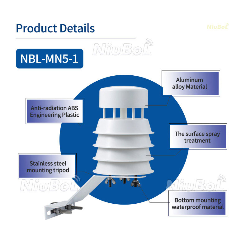
Compared with a consumer handheld meter, the NiuBoL solution is designed around project deployment logic: a rugged collector, industrial sensor interface, low-power operation, optional 4G communication, local storage, and weather data software for query, export, printing, statistics, and curve analysis. This makes the system suitable for engineering teams that need traceable data rather than one-time readings.
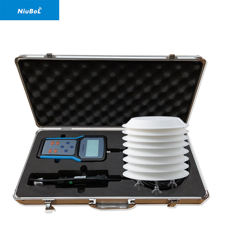
A typical portable deployment includes an integrated ultrasonic weather sensor, a data collector with LCD display, backup battery or solar power supply, mounting support, communication cable, and software platform. The collector can display and store data locally, while the communication layer can be extended to 4G or gateway-based transmission when remote supervision is required.
For IoT solution providers, the key integration value is protocol consistency. RS485 with standard MODBUS allows the sensor package to be connected to edge gateways, industrial computers, PLCs, or project-specific data acquisition terminals. When the same MODBUS logic is used across portable and fixed stations, commissioning data can be compared with later operational data more easily.
| Item | Specification | Integration Value |
|---|---|---|
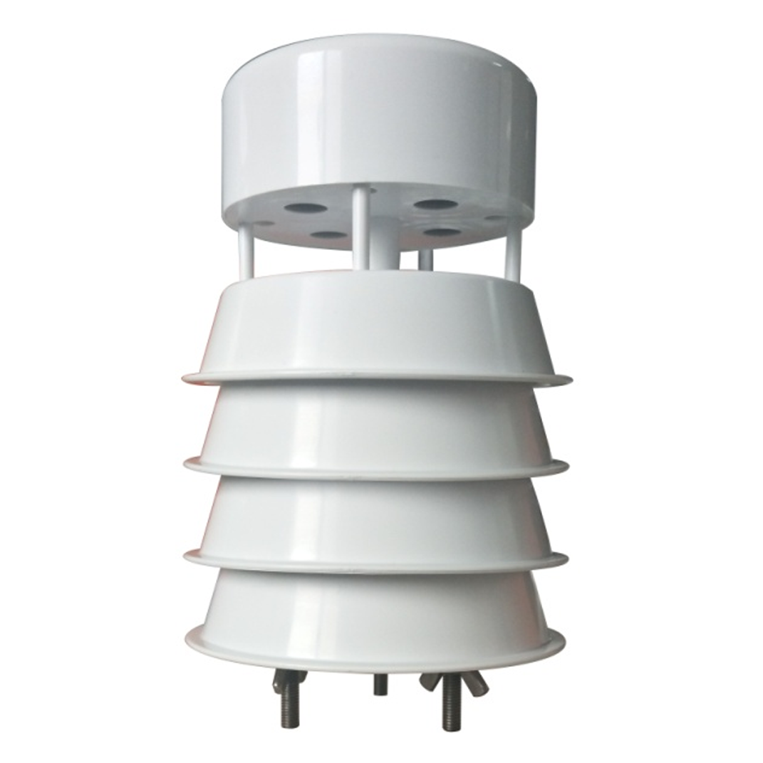
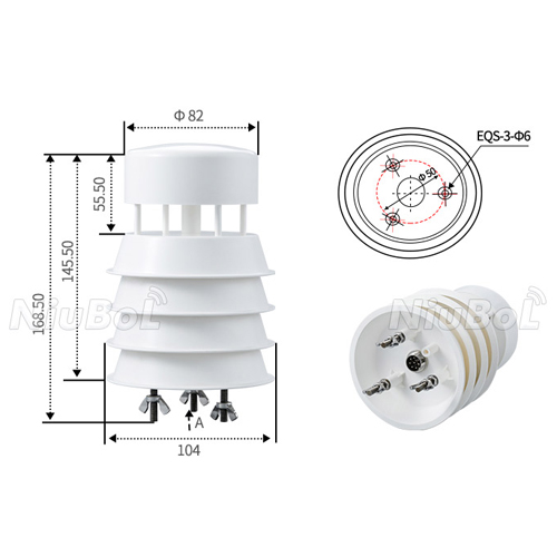
| Model | NBL-W-51MUWS five-parameter ultrasonic weather sensor | Model reference for portable five-parameter weather measurement projects |
| Power Supply | DC 12V | Suitable for battery, solar controller, or industrial power supply integration |
| Signal Output | RS485 | Supports long-distance wired field communication |
| Communication Protocol | Standard MODBUS | Compatible with PLC, RTU, gateway, and SCADA systems |
| Baud Rate | 9600 | Common industrial communication setting |
| Average Power Consumption | 0.3W | Supports low-power mobile and remote deployment |
| Operating Temperature | -40 to 80℃ | Suitable for harsh outdoor environments |
| Protection Class | IP65 | Supports dustproof and weather-resistant installation |
| Parameter | Range | Accuracy / Resolution |
|---|---|---|
| Wind Speed | 0-40m/s | ±0.5 + 2%FS / 0.01m/s |
| Wind Direction | 0-360° | ±3° / 1° |
| Temperature | -50 to 100℃ | ±0.5℃ / 0.1℃ |
| Humidity | 0-100%RH | ±5%RH / 0.1%RH |
| Atmospheric Pressure | 500-1100hPa | ±1.5hPa / 0.1hPa |
In agriculture, the system can be used for pre-installation field surveys, greenhouse-perimeter verification, irrigation zone weather comparison, and temporary crop trial monitoring. In environmental consulting, it can support mobile measurements near construction areas, reservoirs, ecological restoration sites, or sensitive industrial boundaries. For research institutions, it provides a flexible data source for short-term experimental campaigns.
The portable structure is also useful for integrators that need to demonstrate a monitoring solution to a project owner before full deployment. Engineers can use the same data model, communication protocol, and software workflow that will later be adopted in the final weather station network.
Select the five-parameter configuration when the core requirement is wind speed, wind direction, temperature, humidity, and atmospheric pressure. Add rainfall, solar radiation, illuminance, or sunshine duration when the project involves irrigation scheduling, photovoltaic evaluation, road weather service, ecological observation, or agricultural disaster prevention.
For remote fields, confirm whether the power design requires a backup battery, solar panel, or 4G transmission. For mobile use, check mast height, support weight, transport method, wind resistance, and enclosure protection. For public or unattended sites, consider anti-theft structure, cable protection, and mounting stability.
During commissioning, verify sensor address, baud rate, MODBUS register mapping, power polarity, RS485 A/B wiring, grounding, and cable strain relief. The installation should be open enough to avoid turbulent airflow from trees, poles, buildings, or high structures. Wind measurement should follow project-specific height and orientation requirements.
For software integration, define sampling interval, storage frequency, data units, missing-data rules, and export format before acceptance. This helps project teams compare historical datasets and reduces rework when the portable station is later connected to a central monitoring platform.
A portable weather measurement project usually starts with a temporary monitoring objective: baseline survey, construction-period observation, research comparison, emergency inspection, or pre-installation verification for a fixed station. The equipment list should therefore emphasize fast assembly, repeatable measurement, stable local storage, and practical transport rather than only the number of sensor channels.
For mobile teams, the collector, mast, cable, battery, sensor head, and data export method should be packaged as one field kit. Before dispatch, technicians can preset the MODBUS address, sampling interval, file naming rule, and measurement units. This reduces setup time when the team moves between farms, reservoirs, construction sites, or environmental sampling points.
Acceptance for a portable system should include a field checklist: sensor orientation, mounting stability, LCD display, historical data query, export function, backup power, communication test, and comparison with site conditions. This makes the data usable for project reports and later fixed-station design.
When selecting NBL-W-51MUWS five-parameter ultrasonic weather sensor configurations, buyers should confirm whether the package will be used for quick survey, repeated patrol, mobile demonstration, or temporary unattended observation. Each use case changes the importance of mast height, battery capacity, 4G transmission, enclosure weight, local display, and software export functions.
The strongest procurement result is a kit that can be deployed by field technicians without redesigning the communication layer every time. RS485 MODBUS, clear wiring definitions, and consistent data fields make the portable system easier to connect with later weather station networks.
A practical portable configuration can include the NBL-W-51MUWS five-parameter ultrasonic weather sensor, a data collector with LCD display, a portable mast, RS485 cable, backup battery, storage module, and optional 4G transmission. This combination is useful when the same engineering team needs to move between several sites and maintain consistent data fields across each survey point.
For a reservoir survey, the team may collect wind speed, wind direction, temperature, humidity, and pressure at multiple shoreline positions before selecting the final fixed station location. For an agricultural research project, the same portable kit can compare different plots during a trial period. For construction monitoring, temporary data can support site safety records and environmental reporting.
The configuration should be prepared before field dispatch. The collector should use the same parameter names, sampling interval, time zone, and export format required by the project report. If the data will later be imported into a central platform, the file structure and station naming rule should be aligned with the fixed station network from the beginning.
One frequent mistake is selecting a portable instrument only by sensor range while ignoring mast stability, cable protection, backup power, and data export. A mobile system is handled more often than a fixed station, so connectors, brackets, transport packaging, and installation repeatability directly affect data quality.
Another mistake is treating temporary data as informal reference data. In engineering projects, even temporary measurements may be used in site comparison, feasibility reports, or acceptance documents. The system should therefore keep clear timestamps, units, location notes, and calibration or verification records.
For integrators, a portable weather system should also be easy to explain to the project owner. The owner should understand what each parameter means for the project decision, how long the observation period should last, and how the portable dataset will be compared with later fixed-station data.
A good handover package includes the equipment list, sensor model, wiring definition, MODBUS settings, installation photos, data export sample, software screenshot, and field checklist. These materials reduce uncertainty when the device is transferred from the commissioning team to the operation team.
If the project includes several portable units, each unit should have an asset number, cable label, collector setting record, and maintenance note. This keeps field data traceable when teams work in different locations at the same time.
Before installing a permanent weather station, a contractor may use the portable system to compare two or three candidate locations. The team can record wind exposure, pressure trend, temperature variation, and humidity differences over several days. This helps identify whether one location is affected by nearby buildings, trees, road heat, water surfaces, or other local factors.
The portable dataset can also support discussions with the project owner. Instead of selecting the fixed station location only by convenience, the contractor can present measurement evidence and explain why the final position is more representative for the monitoring objective.
For research users, the same workflow supports short-term campaigns. The instrument can be moved according to the experiment plan while still maintaining consistent parameter definitions, units, and export format.
Portable work has a higher risk of inconsistent installation because the equipment is moved frequently. The team should use the same mast height, orientation method, sampling interval, and data export procedure whenever repeated measurements must be compared.
If several technicians operate the system, a short operating procedure should be included in the kit. This procedure should describe startup, sensor connection, data storage, file export, shutdown, and inspection after transport.
A portable system is suitable when the project needs temporary observation, site comparison, field verification, emergency monitoring, or research data before a fixed station is installed. It is especially useful for contractors that need to move between several survey points and keep the same data structure. A fixed station is better for long-term unattended monitoring, while a portable kit is better for flexible deployment and commissioning support.
NBL-W-51MUWS five-parameter ultrasonic weather sensor provides wind speed, wind direction, air temperature, relative humidity, and atmospheric pressure in one compact sensing unit. Its RS485 MODBUS output allows connection to data collectors, RTUs, gateways, or project platforms. For integrators, the key value is consistent data acquisition without separate wind cups, wind vanes, and multiple discrete sensor brackets.
A practical kit should include the ultrasonic sensor, data collector, portable mast, communication cable, backup power, storage or export function, mounting accessories, and a checklist for repeated deployment. If remote supervision is required, a 4G gateway or communication module can be added. The kit should also include wiring definitions and default communication settings so technicians can deploy it quickly in the field.
Wind obstruction, unstable mast installation, incorrect north alignment, nearby buildings, trees, vehicles, water surfaces, and heat sources can all affect readings. For repeatable data, the team should use consistent mounting height, orientation method, sampling interval, and location records. Temporary measurement does not mean casual measurement; field records should be detailed enough for project reports and comparison.
Yes, if the data collection process is controlled and documented. The report should include sensor model, measurement location, installation height, time range, sampling interval, units, and any site conditions that may influence the data. Exported historical data, photos, and configuration records help make the dataset traceable for engineering review.
The portable system should use the same parameter names, units, sampling rules, and communication logic as the later fixed station where possible. This allows early survey data to be compared with long-term station data. For projects using RS485 MODBUS devices, the integrator can reuse register mapping, gateway logic, and platform fields.
Common mistakes include focusing only on sensor range while ignoring mast stability, battery capacity, data export, cable protection, and transport durability. Another mistake is selecting a device without checking whether the data format can be used by the owner’s platform or reporting workflow. A complete procurement request should describe the use case, not only the parameter list.
Maintenance should include checking connectors, cable labels, battery status, collector storage, mast parts, and sensor surface condition before and after field use. Because the system is moved frequently, physical inspection is more important than with a fixed installation. Periodic communication checks and sample data exports also help avoid field delays.
A NiuBoL portable five-parameter weather measurement system gives integrators a practical way to collect reliable field meteorological data before, during, or after project deployment. With RS485 MODBUS compatibility, low-power design, rugged structure, and expandable software workflows, it can become part of a broader weather monitoring, agricultural IoT, environmental assessment, or engineering acceptance solution.
Related recommendations
Sensors & Weather Stations Catalog
 Agriculture Sensors and Weather Stations Catalog-NiuBoL.pdf
Weather Stations Catalog-NiuBoL.pdf
Agriculture Sensors Catalog-NiuBoL.pdf
Water Quality Sensor Catalog-NiuBoL.pdf
Related products
 Combined air temperature and relative humidity sensor
 Soil Moisture Temperature sensor for irrigation|NBL-S-THR
 Soil pH sensor RS485 soil Testing instrument soil ph meter for agriculture |NBL-S-PH
 Wind Speed sensor Output Modbus/RS485/Analog/0-5V/4-20mA
 Tipping bucket rain gauge for weather monitoring auto rainfall sensor RS485/Outdoor/stainless steel
 Pyranometer Solar Radiation Sensor 4-20mA/RS485

Screenshot, WhatsApp to identify the QR code
WhatsApp number:+8615367865107
(Click on WhatsApp to copy and add friends)
