


— Blogs —
—Products—
 Consumer hotline +8618073152920
 WhatsApp:+8615367865107
Address:Room 102, District D, Houhu Industrial Park, Yuelu District, Changsha City, Hunan Province, China
Product knowledge
Time:2026-02-23 09:43:49 Popularity:363
In the context of extreme weather triggered by global climate change, the flood control pressure on small and medium-sized reservoirs and river basins is increasingly intensifying. As the “sentinel” of disaster prevention and mitigation, the real-time nature of data, the stability of equipment in extreme environments, and the self-powering capability in areas without electricity directly determine the effectiveness of early warning and command.
NiuBoL brand is committed to providing a “full perception, fast transmission, intelligent early warning” water and rainfall monitoring system. This article deeply disassembles how to build a low-power, high-performance water and rainfall telemetry station from the perspective of commercial procurement and engineering integration.

NiuBoL water and rainfall monitoring system strictly complies with the technical requirements of relevant departments and adopts an integrated design logic to ensure 7*24 hours unattended operation in harsh outdoor environments.
The system is mainly composed of four key dimensions, forming a complete closed loop:
Field detection equipment: Including non-contact radar water level gauge and high-sensitivity tipping bucket rain gauge.
Data acquisition and control: With NiuBoL telemetry terminal (RTU) or gateway as the core, responsible for protocol conversion, local data storage, and logic control.
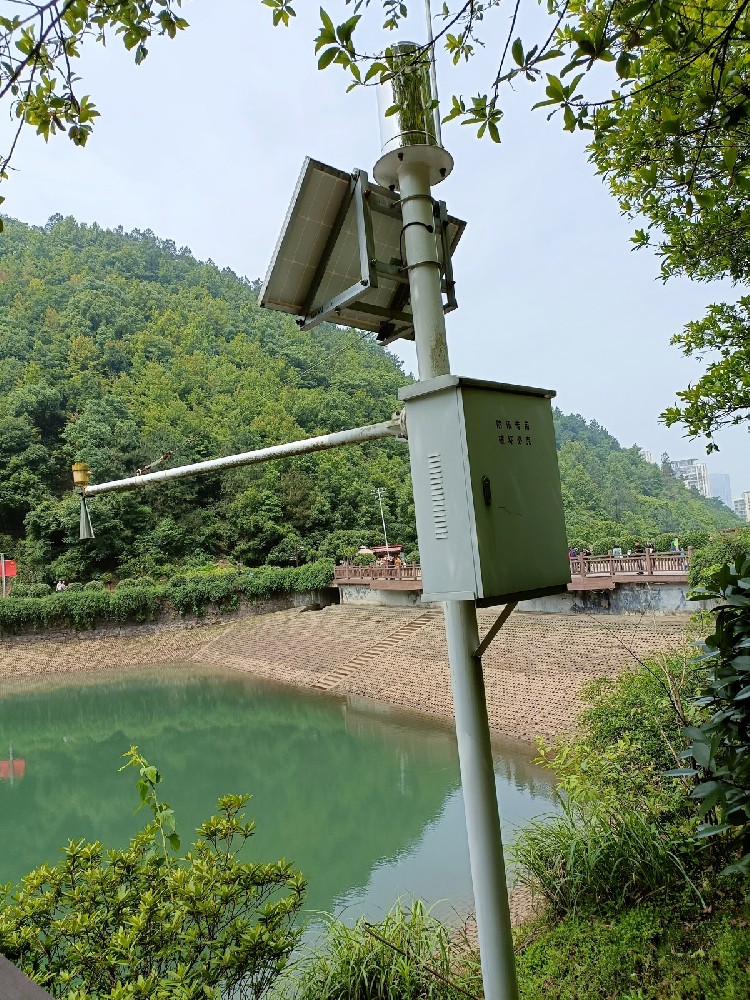
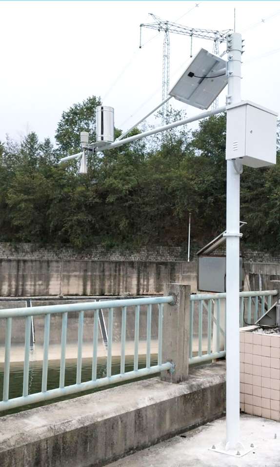
Power supply and protection system: Including solar panels, lithium iron phosphate battery packs, and industrial-grade protective equipment boxes.
Management center: Through the water and rainfall monitoring and early warning platform, realizing data visualization management, GIS geographic information annotation, and multi-terminal early warning release (WEB, mobile, SMS).
In commercial projects, the parameter accuracy and interface richness of hardware are the guarantee of system compatibility. The following are the core component specifications of NiuBoL water and rainfall system:

Adopts 26GHz high-frequency microwave technology. Compared with ultrasonic gauges, it has higher ranging accuracy and stability in strong wind, heavy rain, and foggy environments.
| Indicator | Performance Parameter |
|---|---|
| Measurement Range | 0 - 30m |
| Accuracy | ± 3mm |
| Frequency | 26GHz |
| Output Interface | RS485 (Modbus) / 4-20mA |
| Operating Voltage | 12V DC |
| Installation Method | Bracket, flange or cantilever installation |
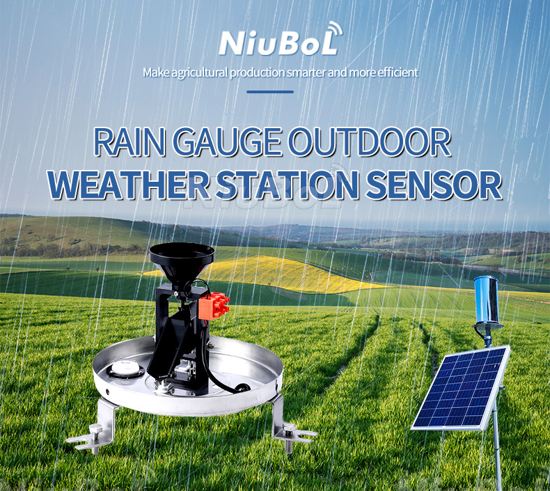
As the standard component for rainfall monitoring, the precision of its outer cutting edge and water receiving orifice directly affects the calculation of precipitation intensity.
| Indicator | Performance Parameter |
|---|---|
| Water Receiving Orifice Diameter | Diameter 200 + 0.6mm (outer cutting edge 45 degrees) |
| Resolution | 0.2mm |
| Measurement Intensity Range | 0mm/min - 8mm/min |
| Static Error | ±3% (under 2mm/min rain intensity) |
| Output Signal | Reed switch pulse signal (on-off) |
| Operating Temperature | -10°C to 60°C |

RTU is the logical core of the system. It not only needs to support multi-sensor access but also must have extremely low static power consumption.
| Function Module | Configuration Description |
|---|---|
| Communication Interface | 2 RS485 channels, 1 TTL channel, SDI-12 interface |
| I/O Interface | 1 pulse input channel, 1 dedicated rain gauge interface, 2 analog channels (4-20mA) |
| Power Control | Supports 2 controllable 12V outputs, 1 controllable 5V output (to save energy) |
| Storage Capacity | Built-in 16M FLASH + 512M TF card (expandable to 256G) |
| Data Backup | Historical data retention no less than 3 years, supports re-reporting function |
| Transmission Network | GPRS / 4G / 5G |
In a certain city's reservoir safety flood control project, it faced difficulties such as no mains power on site, scattered distribution, and the need for image-assisted judgment. The solution provided by NiuBoL specifically addresses these pain points:
1. Ultra-low power consumption and solar endurance
The system supports the working mode of “normal sleep, timed collection, abnormal additional reporting”. In rainy days or when the battery voltage is low, the RTU will trigger an alarm and shorten the collection frequency or turn off the video module according to the strategy to ensure priority transmission of key core data such as water level and rainfall.
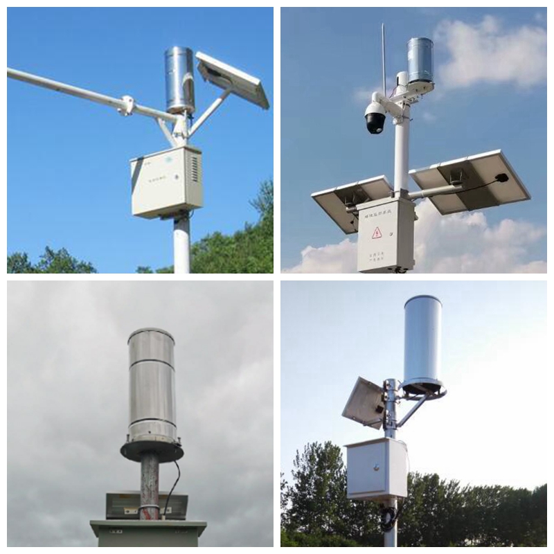
2. Remote image monitoring and video overlay
The telemetry station supports connection to industrial-grade cameras, and the RTU can take timed snapshots of the site and upload them. The system can overlay real-time water level data on the images for decision-makers to visually determine whether the reservoir is overflowing, greatly improving the authenticity of early warnings.
3. Powerful early warning and data security
Data re-reporting: When the wireless signal is temporarily lost, the RTU will automatically store the data and re-report the missed data to the center after the signal is restored to ensure the integrity of the data link.
Three-center reporting: The collected data can be sent to 3 different management centers simultaneously to meet multi-level linkage management needs.
Small and medium-sized reservoir monitoring: Real-time monitoring of storage capacity to provide data basis for scientific flood discharge scheduling.
River channel and flash flood early warning: Deploy integrated stations in flash flood-prone areas. When rainfall or water level reaches the warning threshold, automatically trigger SMS and broadcast warnings.
Irrigation area water measurement: Monitor water level fluctuations at key sections of the irrigation area to optimize water resource allocation.
Urban flood control: Deployed at overpasses and low-lying waterlogging-prone points to assist urban drainage command.

Confirm communication signal: Before purchasing in remote mountainous areas, test the operator signal strength. If 4G signal is extremely weak, consider other transmission solutions.
Range matching: The measurement range of the water level gauge needs to cover the historical highest water level plus 2 meters to avoid equipment damage or data overflow during flood peaks.
Battery capacity calculation: Calculate the battery capacity based on the longest consecutive rainy days in the local area. NiuBoL recommends using lithium iron phosphate batteries, whose low-temperature discharge performance is better than lead-acid batteries.
Lightning protection grounding: Sensors installed at high places must be equipped with professional lightning rods and grounding leads to prevent induced lightning from damaging the RTU motherboard.
Installation levelness: The bottom of the rain gauge must be kept level, otherwise it will cause uneven tipping bucket measurement and generate systematic errors.
Software configuration: At the installation site, channel section parameters can be set through the host computer software, and the RTU can directly convert the instantaneous flow value.
According to different geographical environments, NiuBoL provides standardized installation models:
Bridge suspension type: Use existing bridge piers or guardrails to install stainless steel cross arms, with the radar water level gauge vertically downward.
Vertical pole integrated type: Suitable for open shorelines. Adopt 3-meter or 6-meter lightning protection vertical poles, integrating solar panels, rain gauge, RTU monitoring box, and radar gauge to form an independent water conservancy telemetry unit.
Culvert/tunnel narrow space solution: For areas with limited space, utilize the narrow beam characteristics of millimeter-wave radar to avoid wall echoes and ensure liquid level accuracy in complex structures.
Q1: How does the NiuBoL water and rainfall system work in low battery conditions?
A: The RTU has intelligent voltage monitoring function. When the battery level is below the threshold, the system will automatically shut down high-power-consuming devices such as video, retain only basic water level and rainfall collection, and send a low voltage warning through the cloud platform to remind operation and maintenance personnel.
Q2: How long can historical data be saved?
A: The terminal has a high-capacity storage card built-in. Recording data once per minute can be stored for more than 10 years, and supports data export via USB or remotely.
Q3: Can the radar water level gauge be used in cold and icy areas?
A: The radar water level gauge itself is not affected by temperature. However, if the water surface freezes, the radar measures the ice surface height.
Q4: Does the system support access to sensors from other brands?
A: Yes. The RTU has RS485, analog, and SDI-12 interfaces, compatible with standard ModBus-RTU protocol, and can access third-party water quality, soil moisture, and other equipment.
Q5: What is the delay for publishing early warning information?
A: When the network is smooth, the delay from triggering the warning water level to the cloud platform sending SMS/WEB push is usually within 5-10 seconds.
Q6: How does the solar power supply system resist continuous rainy days?
A: Our standard configuration can support the equipment to work continuously for more than 15 days without any light (non-real-time video preview mode).
Q7: Does installing the radar water level gauge require building a foundation platform?
A: No. The radar water level gauge adopts non-contact installation, usually suspended on bridges or vertical poles through cross arms, with extremely low construction cost.
Q8: If it is necessary to extend monitoring of water quality (such as COD or turbidity), does the existing RTU need to be replaced?
A: No. The NiuBoL telemetry terminal has rich RS485 and analog interfaces and supports the standard ModBus protocol. It is only necessary to add corresponding sensors and remotely update the configuration script to achieve a smooth upgrade from a water and rainfall station to a water quality and quantity integrated station.
NiuBoL automatic water and rainfall monitoring system provides an efficient and low-cost closed-loop solution for reservoir and river flood control through modular integration and low-power technology. From precise radar sensing technology to reliable telemetry terminal data transmission, we ensure that every set of water level and rainfall data can reach the decision-making end in a timely manner.
If you are responsible for the upgrade and transformation of small and medium-sized reservoirs or flood control automation projects, please contact NiuBoL. We will provide you with detailed technical selection manuals, installation plans, and targeted docking solutions.
Related recommendations
Sensors & Weather Stations Catalog
 Agriculture Sensors and Weather Stations Catalog-NiuBoL.pdf
Weather Stations Catalog-NiuBoL.pdf
Agriculture Sensors Catalog-NiuBoL.pdf
Water Quality Sensor Catalog-NiuBoL.pdf
Related products
 Combined air temperature and relative humidity sensor
 Soil Moisture Temperature sensor for irrigation|NBL-S-THR
 Soil pH sensor RS485 soil Testing instrument soil ph meter for agriculture |NBL-S-PH
 Wind Speed sensor Output Modbus/RS485/Analog/0-5V/4-20mA
 Tipping bucket rain gauge for weather monitoring auto rainfall sensor RS485/Outdoor/stainless steel
 Pyranometer Solar Radiation Sensor 4-20mA/RS485

Screenshot, WhatsApp to identify the QR code
WhatsApp number:+8615367865107
(Click on WhatsApp to copy and add friends)
