


— Blogs —
—Products—
 Consumer hotline +8618073152920
 WhatsApp:+8615367865107
Address:Room 102, District D, Houhu Industrial Park, Yuelu District, Changsha City, Hunan Province, China
Product knowledge
Time:2024-11-18 09:00:10 Popularity:1881
Methods and Technologies for Monitoring Hydrometeorological Hazards
Monitoring hydrometeorological hazards is a complex and systematic process that involves multiple disciplines and technologies. The following is a detailed description of the methods and steps involved:
- Floods: River overflow, urban waterlogging, etc.
- Droughts: Long-term water scarcity affecting agriculture and social life.
- Typhoons: Strong winds, heavy rainfall, storm surges, etc.
- Heavy Rainfall: A large amount of rainfall in a short period, potentially leading to flash floods.
- Debris Flows: Mudslides triggered by heavy rainfall in mountainous regions.
- Hailstorms: Hailstones produced by strong convective weather, potentially damaging crops and buildings.
- Frequency: Different regions experience varying frequencies of these hazards.
- Intensity: The strength of the hazard determines its potential to cause damage.
- Impact Area: The geographical range affected by the hazard.
- Potential Damage: The possible harm to people, property, and infrastructure.
- Temperature: Air temperature.
- Humidity: Air moisture content.
- Wind Speed: Wind velocity.
- Wind Direction: Wind's direction.
- Precipitation: Rainfall or snowfall amounts.
- Pressure: Atmospheric pressure.
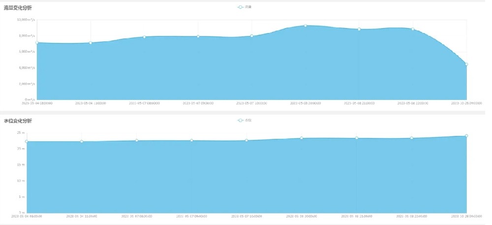
- Water Levels: Levels in rivers, lakes, and reservoirs.
- Flow Rates: Speed and volume of water flow.
- Water Quality: Chemical composition and pollutants in the water.
- Topography: Elevation and slope of the land.
- Landforms: Geological structures and terrain features.
- Soil Types: Physical and chemical properties of soil.
- Vegetation Cover: Types and distribution of surface vegetation.

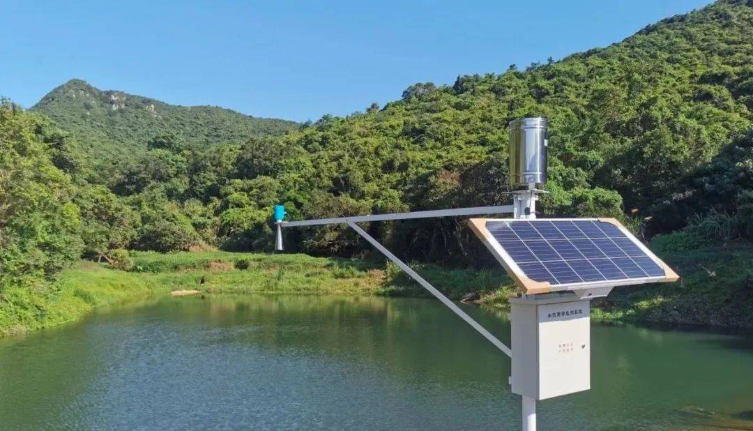
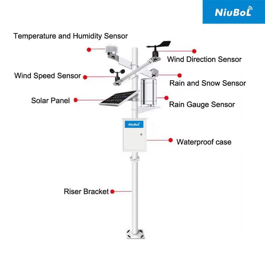
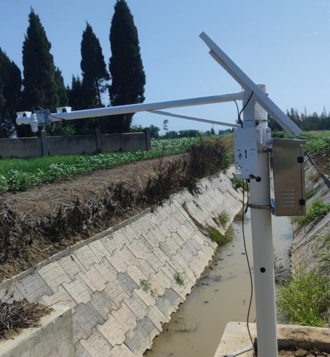
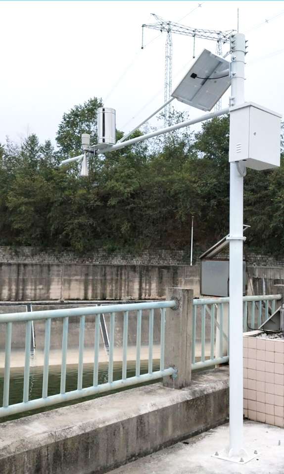
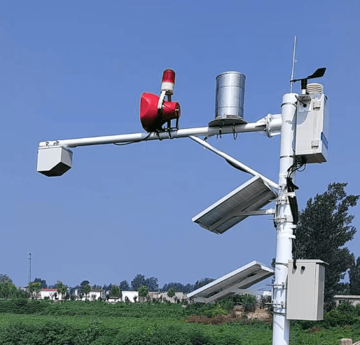
- Meteorological Stations: Equipped with sensors to measure wind speed and direction, rainfall, temperature, humidity, etc., for real-time data collection.
- Hydrological Stations: Equipped with sensors for measuring water levels, flow rates, and water quality.
- Satellite Remote Sensing: Utilizes satellites to gather large-scale surface information, such as high-resolution images from satellites like GaoFen and Planet.
- Aerial Photography: Uses drones to capture high-resolution images for monitoring flood-prone areas and land cover changes.
- Weather Radars: Monitors precipitation, storm systems, and provides real-time radar images.
- Global Positioning System (GPS): Provides precise location data for monitoring points.
- Geographic Information System (GIS): Analyzes and manages geographical data for disaster risk assessment and damage statistics.
- Data Cleaning: Removing outliers and erroneous data.
- Data Validation: Ensuring data accuracy and consistency.
- Data Integration: Combining data from various sources to form a complete dataset.
- Hydrological Models: Simulate rainfall-runoff processes to predict flood occurrences.
- Meteorological Models: Simulate atmospheric movements to predict weather changes.
- Flood Evolution Models: Simulate the propagation of floodwaters in river systems.
- Threshold Setting: Setting early warning thresholds based on historical data and experience.
- Alert Triggers: Automatically activating the warning mechanism when monitored data surpasses the set thresholds.
- Warning Information: Communicating alerts via SMS, emails, and app notifications.
- Continuous Monitoring: Ongoing monitoring of key indicators such as water levels and rainfall amounts.
- Warning Conditions: Establishing alert conditions such as water levels exceeding a warning threshold or rainfall exceeding a set limit.
- Multi-channel Distribution: Disseminating warnings through television, radio, internet, and mobile applications.
- Information Delivery: Ensuring timely transmission of warnings to relevant authorities and the public.
- Notifying Authorities: Alerting government agencies and emergency response teams to activate emergency plans.
- Evacuating People: Providing guidance for evacuations in affected areas.
- Increased Patrols: Strengthening patrols in key areas to promptly identify and manage hazards.
- Impact Assessment: Evaluating the effects of the disaster on people, property, and infrastructure.
- Damage Estimation: Calculating the number of affected individuals and economic losses.
- Lessons Learned: Summarizing the experience and lessons learned from the disaster to improve monitoring and warning systems.
- Adjusting Warning Systems: Refining the warning system parameters and models based on post-disaster evaluations.
- Optimizing Monitoring Plans: Improving the placement of monitoring points and the performance of monitoring equipment to increase accuracy.
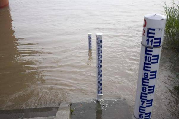
1. Water Level Monitoring: Installing water level gauges at critical points such as rivers, lakes, and reservoirs for real-time monitoring.
2. Flow Rate Monitoring: Using flow meters to measure water flow rates and assess flood risks.
3. Rainfall Monitoring: Employing rain gauges to collect rainfall data for flood predictions.
1. Soil Moisture Monitoring: Using soil moisture sensors to track soil water content and assess drought conditions.
2. Reservoir and Lake Water Level Monitoring: Monitoring water levels in reservoirs and lakes to assess water resource availability.
3. Evaporation Monitoring: Using evaporation sensors to track water surface evaporation rates and assess drought risk.
1. Wind Speed and Direction Monitoring: Using anemometers and wind vanes to monitor typhoon strength and direction.
2. Satellite Cloud Imaging: Analyzing satellite cloud imagery to track typhoon formation and development.
3. Wave Monitoring: Using wave sensors to measure wave heights and assess storm surge risks.
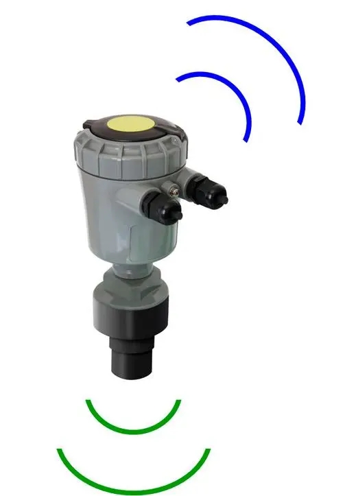
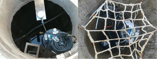
- Sensors: Installing level sensors, ultrasonic sensors, and other types of water-level monitoring instruments to track water levels, flow rates, and water quality.
- Data Collection and Transmission Devices: Collecting data from sensors and transmitting it to data centers using wireless (e.g., GPRS, NB-IoT) or wired communication technologies.
- Sensors: Installing sensors to measure wind speed, wind direction, rainfall, temperature, and humidity for real-time data collection.
- Data Collection and Transmission Devices: Collecting and transmitting data to data centers via wireless communication technologies.
- Satellite Remote Sensing: Provides large-scale, high-resolution imagery to monitor flood-prone areas and land cover changes.
- Drone Aerial Photography: Captures high-resolution images for detailed monitoring in localized areas.
- Data Integration: Combining remote sensing data with GIS to perform disaster risk assessments and statistical analysis.
- Model Building: Using historical and real-time data to construct hydrometeorological models that predict the likelihood and impact of hazards.
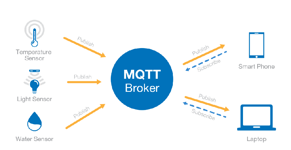
- IoT Technology: Smart sensors installed at monitoring points collect and transmit data via wireless communication to cloud servers.
- Cloud Platform Services: Storing, processing, and analyzing data on cloud platforms, with users accessing the platform via the internet for remote monitoring and data management.
- Data Standardization and Open APIs: Systems designed according to standard protocols and providing API interfaces for data sharing between different systems.
- Automated Alert Systems: Setting thresholds that automatically trigger alerts when monitoring data exceeds pre-set ranges, sending notifications via SMS, email, or app push.
1. Disaster Early Warning: Continuously monitoring rainfall, water levels, and other key parameters to predict floods, droughts, and other hazards, reducing casualties and property damage.
2. Water Resource Management: Providing scientific data for water resource allocation, optimizing irrigation, and ensuring the efficient use of water resources.
3. Environmental and Ecological Protection: Long-term data helps study climate change, protect ecosystems, and guide ecological restoration projects.
4. Decision Support: Providing accurate hydrometeorological data to governments and agencies for planning flood control, urban drainage, and other infrastructure projects.
5. Emergency Response: Offering real-time data to assist in emergency evacuations, rescue operations, and disaster management.
6. Scientific Research and Education: Supporting academic research and raising public awareness of hydrometeorological hazards to strengthen disaster preparedness.
7. Collaborative Networking: Building monitoring networks that allow data sharing and enhance regional disaster response coordination.
Conclusion
Monitoring hydrometeorological hazards requires the integrated use of multiple technologies and methods to establish a comprehensive monitoring system, data processing and analysis framework, and efficient warning and response mechanisms. These measures form a complete chain for monitoring hydrometeorological hazards, providing strong support for disaster prevention and mitigation efforts. Real-time monitoring, data analysis, early warning issuance, and emergency response can effectively reduce losses from disasters and protect people's lives and property.
Related recommendations
Sensors & Weather Stations Catalog
 Agriculture Sensors and Weather Stations Catalog-NiuBoL.pdf
Weather Stations Catalog-NiuBoL.pdf
Agriculture Sensors Catalog-NiuBoL.pdf
Water Quality Sensor Catalog-NiuBoL.pdf
Related products
 Combined air temperature and relative humidity sensor
 Soil Moisture Temperature sensor for irrigation|NBL-S-THR
 Soil pH sensor RS485 soil Testing instrument soil ph meter for agriculture |NBL-S-PH
 Wind Speed sensor Output Modbus/RS485/Analog/0-5V/4-20mA
 Tipping bucket rain gauge for weather monitoring auto rainfall sensor RS485/Outdoor/stainless steel
 Pyranometer Solar Radiation Sensor 4-20mA/RS485

Screenshot, WhatsApp to identify the QR code
WhatsApp number:+8615367865107
(Click on WhatsApp to copy and add friends)
