


— Blogs —
—Products—
 Consumer hotline +8618073152920
 WhatsApp:+8615367865107
Address:Room 102, District D, Houhu Industrial Park, Yuelu District, Changsha City, Hunan Province, China
Product knowledge
Time:2026-02-21 10:20:39 Popularity:413
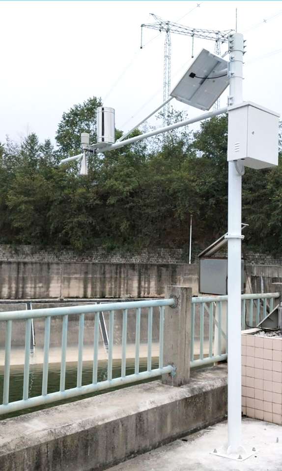
In the context of efficient utilization of agricultural water resources and the informatization upgrade of irrigation districts, real-time channel flow monitoring has become a core technical means for large and medium-sized irrigation districts to achieve precise water distribution, agricultural water price reform, and water-saving irrigation. The NiuBoL radar flowmeter (velocity-level-flow integrated machine) adopts 24GHz radar velocity measurement + 76-81GHz millimeter-wave ranging technology to non-contact measure surface flow velocity and water level of the channel, and calculates the cross-sectional average velocity, wetted area, and instantaneous/cumulative flow through built-in models. The system supports RS485 Modbus-RTU protocol, 10-30V wide voltage power supply, compatible with GPRS/4G telemetry terminals and solar power supply solutions, suitable for open channels, trapezoidal/rectangular cross-sections, Yellow River diversion irrigation districts, and water intake monitoring. For system integrators, IoT platform providers, water conservancy engineering contractors, and irrigation district management units, NiuBoL provides a full-chain solution from front-end sensing to cloud platform access, ensuring accurate data, reliable transmission, and convenient integration.

The NiuBoL irrigation district flow monitoring system adopts a distributed telemetry architecture, covering the field sensing layer, data transmission layer, central processing layer, and application display layer.
Field Sensing Layer: The NiuBoL radar flowmeter integrated machine is fixed on a bracket above the channel (recommended installation height 0-20m), non-contact acquisition of surface velocity (0.1-20 m/s) and water level (0.1-65 m), with built-in algorithms outputting cross-sectional flow. It cooperates with the standard Modbus-RTU protocol and connects to the telemetry terminal via RS485 interface.
Data Acquisition and Transmission Layer: The telemetry terminal (RTU) collects flow data at timed/incremental intervals, supporting GPRS/4G public network transmission. The system is compatible with timed self-reporting, polling, and self-reporting confirmation mechanisms, with data latency generally <30 seconds.
Power Supply Assurance: Solar panel + colloidal battery (typical 12V 38Ah) solution, with maximum power consumption controlled at 1.3W, ensuring continuous operation in remote channels without mains power. Equipped with charge controller, lightning protection module, and IP67 protective enclosure.
Civil Fixed Installation: Pole, lightning rod, ground cage to fix the enclosure and sensor, adapting to outdoor environments from -40℃ to +80℃.
Central Platform: The server receives and parses messages, establishes a time-series database, supports WEB/mobile browsing of real-time flow, cumulative water consumption, historical curves, over-limit alarms, and report export. MQTT/HTTP interfaces are reserved for easy access to water resources monitoring platforms or irrigation district SCADA systems.

NiuBoL Radar Flowmeter (Velocity-Level-Flow Integrated Machine)
| Parameter | Technical Specifications |
|---|---|
| Power Supply Voltage | DC 10-30 V |
| Maximum Power Consumption | 1.3 W |
| Operating Temperature/Humidity | -40℃ ~ +80℃, 0%~95% RH (non-condensing) |
| Velocity Measurement Band | 24.00 GHz |
| Velocity Range | 0.1 ~ 20 m/s |
| Velocity Accuracy | ±2% |
| Velocity Resolution | 0.01 m/s |
| Ranging Band | 76 GHz ~ 81 GHz |
| Water Level Range | 0.1 ~ 65 m |
| Water Level Accuracy | ±1 mm |
| Water Level Resolution | 1 mm |
| Installation Height | 0 ~ 20 m |
| Communication Interface | RS485 (standard Modbus-RTU) |
| Protection Level | IP67 |
Features: Non-contact measurement is free from sediment and sewage corrosion effects; dual-band design ensures stable output under complex water surfaces (such as waves, floating objects); built-in flow calculation model supports custom cross-section parameters and calibration of correction coefficients.

1. Large Irrigation District Main and Branch Canal Metering
Main and branch canals are equipped with monitoring points to achieve full-process monitoring of incoming water volume - diverted water volume - conveyance losses, supporting precise water distribution and water-saving assessment.
2. Agricultural Water Price Reform Water Intake Monitoring
Deployed at national/provincial controlled water intakes to meet the requirements of the "National Water Resources Monitoring Capacity Building Project", providing real-time flow data access to provincial platforms for volume-based charging.
3. Medium and Small Irrigation District Lateral Canal End Metering
For channels with width 1-5m and depth <5m, non-contact installation simplifies construction, reduces maintenance frequency, and improves end canal system water use efficiency.
4. Yellow River Diversion Irrigation District and High Sediment Channels
Radar technology is unaffected by sediment concentration, suitable for high-turbidity channels in northwest and Yellow River basins, ensuring data continuity.
5. Water-Saving Irrigation Demonstration Areas
Combined with soil moisture and crop water demand models, linked with gate control to achieve closed-loop intelligent irrigation.
Selection Reference
Channel Cross-Section: Rectangular/trapezoidal small channels (width <5m) prefer integrated machine; wide open channels can be equipped with independent radar velocimeter + level gauge.
Velocity Range: Conventional irrigation channels select 0.1-20 m/s range; low velocity scenarios (<0.2 m/s) need evaluation whether supplementary means are required.
Power Supply Method: Remote points must use solar + battery; mains power available can choose DC power supply to simplify maintenance.
Communication Distance: RS485 up to 2000m, if exceeded, suggest nearby access to RTU or add repeater.
Platform Compatibility: Prefer Modbus-RTU devices for easy docking with existing SCADA or water conservancy IoT platforms.
Integration Notes
1. Installation Position: Sensor directly facing the water flow direction, irradiation area to avoid branches and bank slope reflections; recommended installation height higher than maximum water level + safety margin.
2. Cross-Section Parameter Calibration: Field measurement of channel geometric dimensions, input correction coefficients; it is recommended to perform actual flow comparison verification after initial commissioning.
3. Protocol Configuration: RTU side configures Modbus address and baud rate (default 9600), ensure consistency with flowmeter; enable CRC check.
4. Lightning Protection Grounding: Pole, enclosure, solar panel independent grounding, resistance <4 Ω; install surge protectors.
5. Data Processing: Platform enables outlier filtering, manual interpolation, supports dynamic adjustment of cross-section models.
6. Maintenance Cycle: Non-contact design requires little maintenance, but it is recommended to check antenna cleanliness, battery capacity, and firmware upgrades annually.

Q1: Can the radar flowmeter work stably for a long time in high-sediment or sewage channels?
A: Yes. 24GHz/76-81GHz non-contact technology is unaffected by sediment and corrosion, and has been verified in multiple high-sediment environments such as northwest Yellow River diversion irrigation districts.
Q2: What is the minimum measurable flow velocity limit of the system?
A: Starts measurement at 0.1 m/s, accuracy decreases below this value; for flow velocity <0.2 m/s scenarios, it is recommended to adjust correction coefficients based on actual comparison.
Q3: How many consecutive rainy days can the solar power supply support?
A: Typical 12V 30Ah battery + adapted solar panel configuration can support 7-10 consecutive rainy days, depending on local sunlight and power consumption optimization.
Q4: How is the data transmission delay and reliability?
A: Under GPRS/4G, timed self-reporting <30 seconds, polling response <10 seconds; supports self-reporting confirmation mechanism, packet loss retransmission ensures reliability.
Q5: Can it be integrated with third-party platforms or old systems?
A: Yes. Supports standard Modbus-RTU protocol for easy protocol conversion; has been successfully connected to multiple water conservancy cloud platforms and SCADA systems.
Q6: How to handle large changes in channel cross-section?
A: Supports custom cross-section parameters and multi-segment models; the platform can periodically update geometric data to maintain calculation accuracy.
Q7: Is installation and maintenance difficult?
A: Non-contact fixed bracket installation, no underwater work required; daily only needs antenna cleaning, far lower than traditional velocimeters.
Q8: What after-sales services does NiuBoL provide?
A: 1-3 year warranty, remote diagnosis, on-site commissioning guidance, spare parts response, and annual maintenance contract.

The NiuBoL irrigation district channel flow monitoring solution takes high-precision radar flowmeter as the core, combined with low-power telemetry terminals, solar power supply, and cloud platform access, fully solving problems such as sparse observation points, backward means, and delayed transmission in traditional irrigation districts. The system helps irrigation district managers shift from empirical scheduling to data-driven and precise water distribution, supporting agricultural water saving, ecological protection, and sustainable utilization of water resources.
For system integrators and engineering companies seeking reliable, non-contact open channel flow monitoring equipment, NiuBoL can provide customized selection, integration guidance, and long-term operation and maintenance support. Welcome to contact us for detailed technical solutions, cross-section adaptation suggestions, or reference project materials to jointly promote the informatization construction of irrigation districts.
Prev:Remote Monitoring Solution for Urban Stormwater and Sewage Pipe Networks Based on Doppler Flowmeter
Related recommendations
Sensors & Weather Stations Catalog
 Agriculture Sensors and Weather Stations Catalog-NiuBoL.pdf
Weather Stations Catalog-NiuBoL.pdf
Agriculture Sensors Catalog-NiuBoL.pdf
Water Quality Sensor Catalog-NiuBoL.pdf
Related products
 Combined air temperature and relative humidity sensor
 Soil Moisture Temperature sensor for irrigation|NBL-S-THR
 Soil pH sensor RS485 soil Testing instrument soil ph meter for agriculture |NBL-S-PH
 Wind Speed sensor Output Modbus/RS485/Analog/0-5V/4-20mA
 Tipping bucket rain gauge for weather monitoring auto rainfall sensor RS485/Outdoor/stainless steel
 Pyranometer Solar Radiation Sensor 4-20mA/RS485

Screenshot, WhatsApp to identify the QR code
WhatsApp number:+8615367865107
(Click on WhatsApp to copy and add friends)
