


— Blogs —
—Products—
 Consumer hotline +8618073152920
 WhatsApp:+8615367865107
Address:Room 102, District D, Houhu Industrial Park, Yuelu District, Changsha City, Hunan Province, China
Product knowledge
Time:2026-02-21 10:27:11 Popularity:422
In the current national infrastructure projects such as smart water conservancy, urban flooding prevention and control, and modernization of irrigation districts, higher requirements are placed on the real-time performance, continuity, and anti-interference capability of water flow data. Traditional contact flowmeters (such as electromagnetic, ultrasonic Doppler probes) are prone to sensor blockage, corrosion, drift, or even damage under conditions of high sediment content, abundant floating debris, strong corrosiveness, or high velocity during floods, leading to data interruption or distortion.
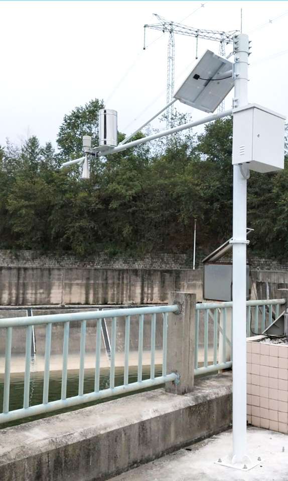
The NiuBoL radar velocity flowmeter emerges in response — based on planar microstrip radar technology, it achieves non-contact synchronous measurement of surface velocity and water level, completely avoiding maintenance risks caused by physical contact. It has been successfully deployed in multiple provincial hydrological station networks, large irrigation district automation projects, and urban drainage and flood prevention systems, becoming a key sensing layer device in water conservancy informatization construction.

The NiuBoL radar flowmeter is not a single sensor but an integrated hydrological sensing unit. Its flow calculation logic follows the basic hydraulic formula:
Q = Vₐᵥ × A × K
Where:
Q: Cross-sectional flow (m³/s)
Vₐᵥ: Cross-sectional average velocity (m/s), derived from surface velocity corrected by hydraulic models
A: Wetted cross-sectional area (m²), calculated from measured water level and preset cross-section parameters
K: Velocity distribution correction coefficient (calibrated based on channel/river cross-section shape)
Dual Radar Collaborative Working Mode
24.00 GHz Radar: Used to measure surface layer velocity, beam angle 30°×80°, irradiation area elliptical, effectively covering the main flow zone;
76–81 GHz High-Frequency Radar: Used for high-precision water level measurement, beam angle only 6°×6°, ranging accuracy ±1 mm, maximum range 65 m.
This design ensures stable acquisition of key hydrological parameters even under complex conditions such as high water level submergence, floating garbage accumulation, and vegetation occlusion.

| Feature | Technical Implementation | Engineering Value |
|---|---|---|
| Non-Contact Measurement | Millimeter-wave radar penetrates air medium, no need to enter water | Maintenance-free, no wear, anti-corrosion, suitable for sewage and high-sediment rivers |
| Wide Environmental Adaptability | -40℃ ~ +80℃ operating temperature, IP68 protection, built-in lightning protection circuit | Suitable for long-term field deployment in plateaus, cold regions, tropics, etc. |
| Low Power Consumption Operation | Maximum power consumption only 1.3 W, supports sleep-wake mechanism | Perfectly matches solar + battery power supply systems, reduces maintenance costs |
| Communication Standardization | RS-485 interface, standard Modbus-RTU protocol, communication distance ≤2000 m | Seamlessly connects to mainstream telemetry terminals such as RTU, DTU, PLC, quickly integrates into existing hydrological platforms |
| Integrated Structure | Velocity, water level, flow three-in-one integration, compact size | Reduces installation points, lowers pole and wiring costs |

1. Large and Medium-Sized Irrigation District Canal System Flow Monitoring
Applied to main canals and branch canal diversion outlets for water metering and scheduling optimization; supports regular open channels (rectangular, trapezoidal) after cross-section regularization, automatically calculates instantaneous/cumulative flow with cross-section parameter input; has deployed over 200 units in a large irrigation district in the Yellow River Basin, replacing original Parshall flume + ultrasonic solutions, reducing annual maintenance costs by 60%.
2. Urban Drainage Pipe Network and Drainage Pumping Stations
Installed in rainwater culverts, flood drainage ditches, and pre-pump basins to monitor velocity and water level in real time during heavy rain; maintains ±2% velocity measurement accuracy at high velocities (≤20 m/s), supporting urban flooding warning models; links with urban smart water affairs platforms to trigger pump start/stop or overflow alarms.
3. Supplementary Monitoring for Natural River Hydrological Station Networks
Deployed in simple pole stations on small and medium rivers without boats or cableways; uses cloud platform for remote calibration and data backtracking to improve hydrological station network density; particularly suitable for key mountain flood disaster prevention areas, achieving "measurement instead of reporting".
4. Flood Emergency and Temporary Monitoring
Rapid installation on bridges or temporary brackets, completed within 72 hours; battery + solar power supply, supports 4G/NB-IoT remote transmission, meeting emergency command needs.

Installation Location Selection
Prefer straight, stable sections with concentrated flow; upstream and downstream at least 10 times channel width free of bends, gates, or drops;
Avoid installation in vortex, backflow areas, or floating debris accumulation points;
Device inclined face directly facing flow direction, installation height recommended 1–10 m (adjusted based on range and beam coverage).
System Integration Key Points
Communication Docking: Confirm telemetry terminal supports Modbus-RTU protocol, refer to NiuBoL provided communication manual for register addresses;
Power Configuration: Recommend 12 V or 24 V DC power supply, solar system needs ≥60 W PV panel + 30 Ah battery;
Cross-Section Parameter Input: Use supporting software to input channel bottom width, side slope coefficient, roughness, etc., for area and correction coefficient calculation;
Anti-Interference Measures: Avoid high-voltage lines, metal reflective surfaces, high-frequency radio equipment; add shielding cover if necessary.
Q1: Does the radar flowmeter require regular calibration?
A: Factory calibration for velocity and distance is completed. On-site, it is recommended to perform comparison tests (e.g., using ADCP or velocimeter) every 12 months to verify if the correction coefficient K drifts.
Q2: Can it be used for natural river channels with irregular cross-sections?
A: Yes. By modeling multi-point water level-area relationships or importing CAD cross-section diagrams, the system can dynamically calculate wetted area, but the water level measurement point must be representative.
Q3: Will a large amount of floating debris on the water surface (such as branches, plastic) affect the measurement?
A: The 77GHz water level radar, with narrow beam and high frequency, can penetrate small floating objects; the 24GHz velocity radar is sensitive to surface motion targets, but the algorithm filters out instantaneous clutter and only extracts mainstream velocity.
Q4: What conditions does the maximum communication distance of 2000 meters refer to?
A: Refers to RS-485 twisted pair environment without repeaters and good shielding. If the distance is exceeded, it is recommended to add signal repeaters or switch to 4G transmission.
Q5: Does it support multi-device networking?
A: Yes. Devices are distinguished by Modbus addresses; a single RS-485 bus can connect up to 32 devices, suitable for multi-section joint monitoring.
Q6: How to access hydrological platforms with the data?
A: After parsing Modbus data via RTU, or directly docking MQTT/HTTP API to cloud platforms.
Q7: Does ice formation in winter affect the measurement?
A: Ice surface reflects radar waves, causing water level readings to show ice surface elevation. It is recommended to switch to "ice surface mode" during ice periods or use temperature data for logical judgment.

The NiuBoL radar velocity flowmeter is not just a sensor but a standardized interface device for the sensing layer of smart water conservancy. With its four core advantages — non-contact, low power consumption, high compatibility, and strong environmental adaptability — it solves the reliability bottlenecks of traditional flow measurement methods in complex field scenarios. Whether for new irrigation district automation projects, urban flooding monitoring systems, or the construction of national water network digital twin bases, NiuBoL can provide plug-and-play, long-term stable flow data support.
For water conservancy design institutes, system integrators, and water affairs operation units, choosing NiuBoL means selecting a professional hydrological monitoring solution that can be deployed on a large scale, remotely maintained, and seamlessly integrated into existing informatization architectures.
Prev:NiuBoL Radar Flowmeter Assists Precise Irrigation and Water-Saving Management
Next:High-Precision Radar Flowmeter Integrated Applications and Technical Solutions Explained
Related recommendations
Sensors & Weather Stations Catalog
 Agriculture Sensors and Weather Stations Catalog-NiuBoL.pdf
Weather Stations Catalog-NiuBoL.pdf
Agriculture Sensors Catalog-NiuBoL.pdf
Water Quality Sensor Catalog-NiuBoL.pdf
Related products
 Combined air temperature and relative humidity sensor
 Soil Moisture Temperature sensor for irrigation|NBL-S-THR
 Soil pH sensor RS485 soil Testing instrument soil ph meter for agriculture |NBL-S-PH
 Wind Speed sensor Output Modbus/RS485/Analog/0-5V/4-20mA
 Tipping bucket rain gauge for weather monitoring auto rainfall sensor RS485/Outdoor/stainless steel
 Pyranometer Solar Radiation Sensor 4-20mA/RS485

Screenshot, WhatsApp to identify the QR code
WhatsApp number:+8615367865107
(Click on WhatsApp to copy and add friends)
