


— Blogs —
—Products—
 Consumer hotline +8618073152920
 WhatsApp:+8615367865107
Address:Room 102, District D, Houhu Industrial Park, Yuelu District, Changsha City, Hunan Province, China
Product knowledge
Time:2026-02-21 10:46:29 Popularity:364
In the construction of water conservancy informatization and engineering automation, the reservoir water and rainfall automatic reporting system has become the core technical support for achieving flood control and disaster mitigation, optimized scheduling, and efficient resource utilization. NiuBoL, as a professional hydrological monitoring equipment manufacturer, focuses on providing high-precision, scalable radar level gauges, tipping bucket rain gauges, and complete telemetry terminal solutions to system integrators, IoT solution providers, general project contractors, and water conservancy engineering companies. The system is based on GPRS/4G public network communication, RS485/4-20mA interface protocols, and supports seamless integration with mainstream SCADA and water conservancy cloud platforms. It is suitable for large and medium-sized reservoirs, mountain flood channels, ecological flow monitoring, and other scenarios.

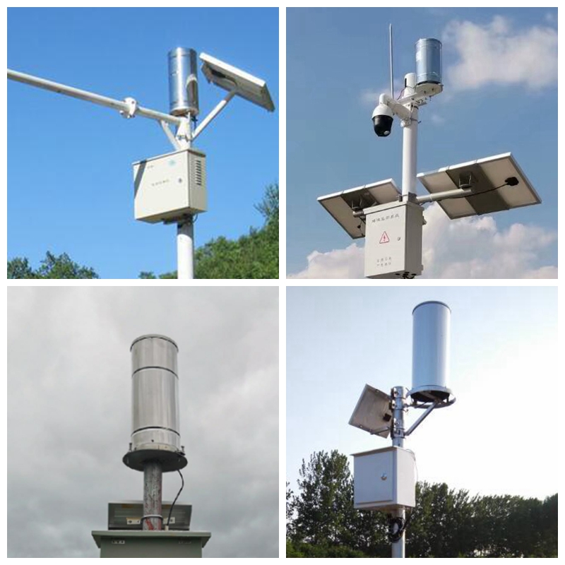
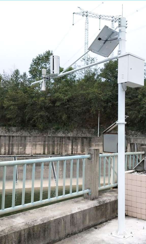
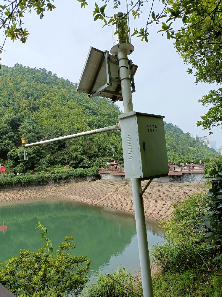
The NiuBoL reservoir hydrological automatic reporting system adopts a layered distributed architecture, mainly consisting of the monitoring center station, communication network layer, field telemetry station, and power assurance system.
Monitoring Center: Deploys high-availability server clusters integrated with a dedicated hydrological database. It achieves real-time aggregation of multi-station data, historical data query, curve display, hydrological chart generation, and hierarchical warning push notifications.
Communication Network: Supports GPRS/4G/5G public network, wired fiber optic/Ethernet backup. Adopts multiple working modes including timed self-reporting + incremental self-reporting + master station polling + self-reporting confirmation, ensuring data transmission timeliness (second-level response) and reliability (low-power design, mean time between failures ≥50,000 hours).
Telemetry Station: Integrates radar level gauge, tipping bucket rain gauge, industrial camera (supports timed/triggered photography), and RTU telemetry terminal. The terminal uses a low-power MCU as the core, providing multi-channel sensor interfaces (RS485, pulse, analog), large-capacity local storage, and remote firmware upgrade functions.
Power Supply and Protection: Solar + lithium iron phosphate battery pack solution, equipped with lightning protection modules (surge protection) and IP67 protective equipment boxes, adapting to field environments from -40℃ to +80℃.

The NiuBoL radar level gauge adopts a self-developed CMOS millimeter-wave RF chip, achieving smaller blind zones, higher resolution, and stronger anti-interference capability. It is suitable for reservoir environments with large water surface fluctuations and abundant floating debris interference.
| Parameter | Technical Index |
|---|---|
| Operating Frequency Band | 77GHz ~ 79GHz |
| Measurement Range | 0.15 m ~ 65 m (customizable up to 70 m) |
| Blind Zone | ≤ 0.15 m |
| Resolution | 1 mm |
| Measurement Accuracy | ±1 mm (at 4 m distance, 40% RH, 25℃ conditions) |
| Beam Angle | 8° |
| Power Supply Voltage | DC 10-30 V |
| Maximum Power Consumption | 0.6 W |
| Operating Temperature | -40℃ ~ +80℃ |
| Protection Rating | IP67 |
| Output Interface | RS485 (Modbus RTU), 4-20 mA optional |
| Installation Method | Nut fixed, compatible with standard poles |
Features: Narrow beam design effectively suppresses interference from surrounding bridges and bank slopes; built-in filtering compensation algorithm eliminates effects from wind waves and minor vibrations; non-contact measurement, no underwater installation required, low maintenance cost.
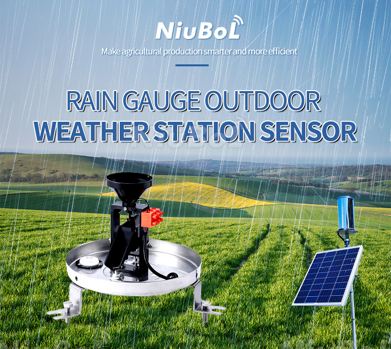
Adopts precision injection-molded engineering plastic tipping bucket with mechanical bistable structure for long-term stability. The water-receiving orifice complies with meteorological specifications.
| Parameter | Technical Index |
|---|---|
| Water-Receiving Orifice Diameter | Φ200 mm +0.6 mm, outer edge 45° |
| Resolution | 0.1 mm or 0.2 mm (optional) |
| Measured Rainfall Intensity | 0 ~ 8 mm/min |
| Error | ±3% (indoor static test, 2 mm/min) |
| Output Signal | Single/dual reed switch on/off (pulse) |
| Switch Capacity | DC ≤12 V, ≤500 mA |
| Operating Temperature | 0 ~ 55℃ |
| Operating Environment Humidity | ≤90% RH (40℃, condensing) |
| Mean Time Between Failures | ≥50,000 hours |

1. Large and Medium-Sized Reservoir Group Water and Rainfall Monitoring
Multi-point deployment of radar level gauges + rain gauges to achieve linkage analysis of reservoir water level - inflow - rainfall, supporting dynamic control of flood limit water levels and scheduling scheme generation.
2. Mountain Flood Disaster Early Warning System
Deploy small integrated stations at key channel sections, combining radar water level and rainfall data to trigger threshold alarms and link downstream warning broadcasts/SMS.
3. Ecological Flow Monitoring and River Chief System
Installed at river control sections to provide continuous water level and flow data (requires coordination with velocimeter), supporting ecological discharge flow assessment.
4. Hydropower Station Optimized Scheduling
Real-time hydrological data access to station automation systems for closed-loop optimization of incoming water forecast - generation plan - spillway control.
5. Cross-Regional Water Resources Monitoring Platform
Multi-level networking architecture supporting data aggregation and sharing at municipal and provincial platforms.
Selection Reference
Measurement Range: Small and medium reservoirs select 30-50 m range; large reservoirs or deep storage select 65-70 m.
Communication Method: Remote areas without network prioritize 4G + solar; areas with fiber optics can use wired backup.
Output Interface: Mainstream integration selects RS485 Modbus RTU protocol; for old systems, pair with 4-20 mA.
Power Consumption Requirements: Strictly control<1 W devices in solar-powered scenarios.
Environmental Adaptability: High humidity/salt fog areas add anti-corrosion coating or stainless steel enclosure.
Integration Notes
1. Protocol Compatibility: Confirm RTU supports standard hydrological industry message formats to avoid later protocol conversion costs.
2. Test Verification: Perform full-range static/dynamic calibration before project acceptance; rain gauge recommended to use flow generator for verification.
3. Time Synchronization: All devices support NTP/SNTP to ensure consistent timestamps.
4. Lightning Protection Grounding: Radar antenna, solar panel, and equipment box require independent grounding with resistance<4 Ω.
5. Installation Height: Radar level gauge installation height should be higher than maximum water level + safety margin, with no fixed obstructions in the beam range.
1. Can the radar level gauge work normally on water surfaces with a large amount of floating debris or foam?
A: Yes. The 8° narrow beam + professional filtering algorithm can effectively filter out instantaneous interference from floating objects, with high long-term stability.
2. How many sensor channels can one telemetry terminal support simultaneously?
A: Standard configuration supports 4-8 channels (water level ×2, rainfall ×2, video, spare analog/digital), expandable as needed.
3. How to ensure continuous operation in remote mountainous areas without mains power?
A: Using 80-120 W solar panels + 100-200 Ah lithium iron phosphate battery packs, typical configurations support 7-10 days of continuous rainy weather.
4. What is the typical data transmission delay?
A: Under GPRS/4G channels, timed self-reporting delay is usually<30 seconds, polling response <10 seconds (depending on network conditions).
5. Does it support docking with third-party platforms?
A: Yes. Provides Modbus, MQTT, HTTP POST and other interfaces, successfully integrated with multiple water conservancy cloud platforms.
6. What after-sales support does NiuBoL provide?
A: Offers 1-3 year warranty, remote diagnosis, on-site commissioning guidance, quick spare parts response, and annual maintenance contract options.
The NiuBoL reservoir water and rainfall automatic reporting system takes high-precision radar water level measurement, reliable tipping bucket rainfall collection, low-power telemetry terminals, and stable communication links as its core, assisting system integrators and engineering companies in efficiently delivering projects that meet water conservancy informatization requirements. Whether for new hydrological station clusters or upgrades of old systems, we can provide full-chain solutions from sensor selection and system integration to long-term operation and maintenance.
If you need detailed technical solutions, project cases, or product selection support, welcome to contact the NiuBoL technical team. We are committed to providing stable and reliable monitoring data foundations for water conservancy projects, jointly promoting the intelligent and refined management of water resources.
Related recommendations
Sensors & Weather Stations Catalog
 Agriculture Sensors and Weather Stations Catalog-NiuBoL.pdf
Weather Stations Catalog-NiuBoL.pdf
Agriculture Sensors Catalog-NiuBoL.pdf
Water Quality Sensor Catalog-NiuBoL.pdf
Related products
 Combined air temperature and relative humidity sensor
 Soil Moisture Temperature sensor for irrigation|NBL-S-THR
 Soil pH sensor RS485 soil Testing instrument soil ph meter for agriculture |NBL-S-PH
 Wind Speed sensor Output Modbus/RS485/Analog/0-5V/4-20mA
 Tipping bucket rain gauge for weather monitoring auto rainfall sensor RS485/Outdoor/stainless steel
 Pyranometer Solar Radiation Sensor 4-20mA/RS485

Screenshot, WhatsApp to identify the QR code
WhatsApp number:+8615367865107
(Click on WhatsApp to copy and add friends)
