


— Blogs —
—Products—
 Consumer hotline +8618073152920
 WhatsApp:+8615367865107
Address:Room 102, District D, Houhu Industrial Park, Yuelu District, Changsha City, Hunan Province, China
Product knowledge
Time:2025-12-26 11:06:54 Popularity:615
In the process of building modern river hydrological information systems, water and rainfall conditions and flow monitoring are core pillars. With frequent extreme precipitation events caused by global climate anomalies, traditional monitoring methods can hardly meet the needs of “precise flood prevention and scientific dispatching.”
The automated hydrological monitoring station launched by NiuBoL, through real-time capture and integration of key parameters such as rainfall, water level, and flow, not only provides precise docking for flood control and drainage strategies but also fundamentally enhances basin risk resistance. This article will deeply disassemble this smart water conservancy tool from multiple dimensions including system architecture, technical characteristics, energy consumption management, and application value.
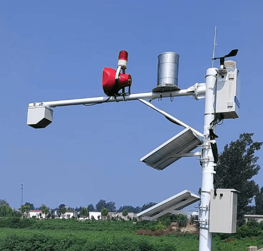
An automated hydrological monitoring station is a highly integrated system aiming to ensure continuous and accurate real-time data flow for water and rainfall application systems. NiuBoL system builds a complete technical closed loop through four layers:
Core Perception Layer (Sensor Matrix)
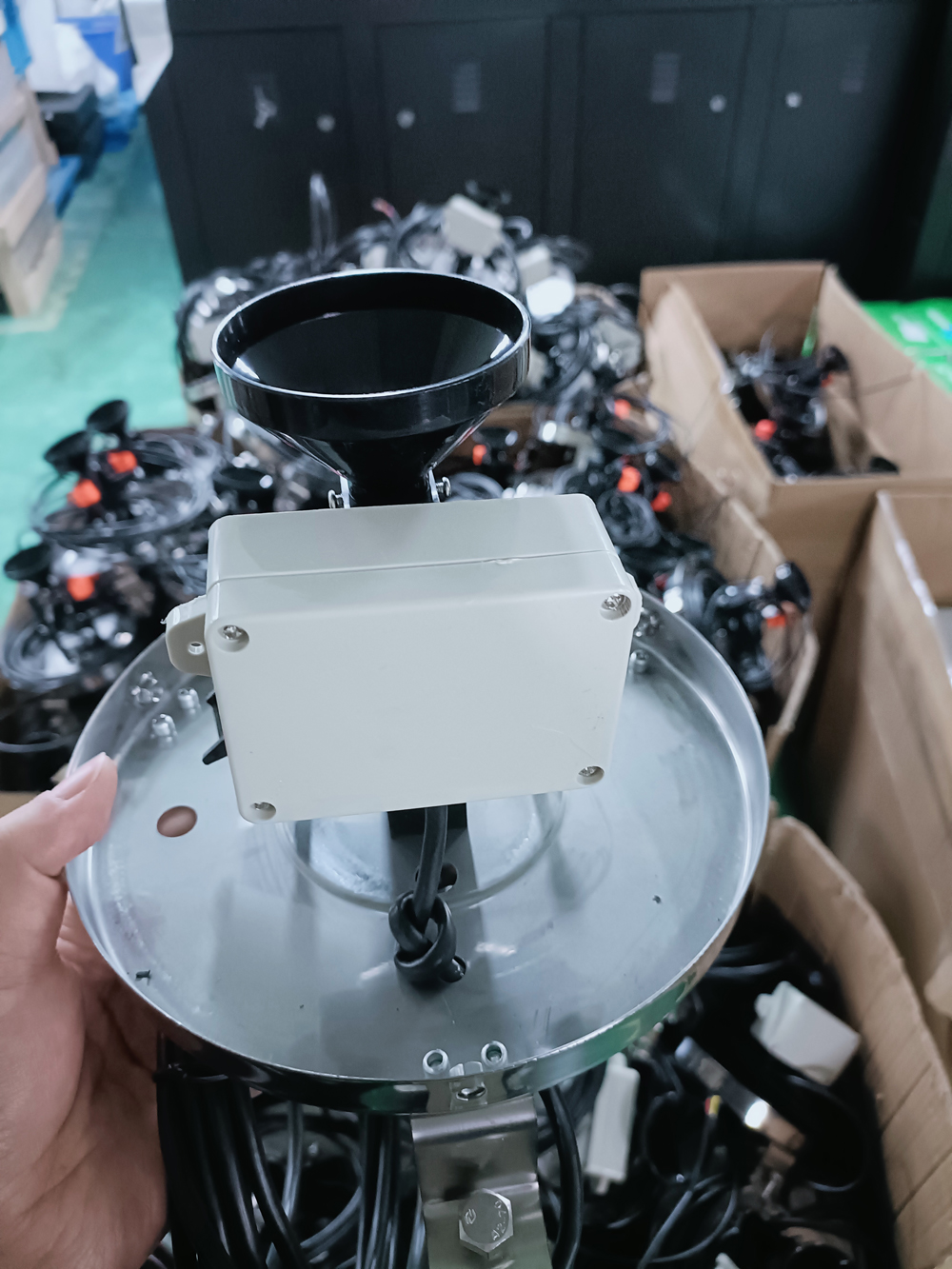
High-Precision Rainfall Monitoring: Adopts tipping bucket or radar rain gauge. Stainless steel material design ensures corrosion resistance in harsh environments, accurately recording rainfall intensity and cumulative rainfall per minute.
Non-Contact Water Level Monitoring: NiuBoL radar water level gauge utilizes millimeter wave technology, avoiding interference from river silt, surface floating debris, and water corrosion; range up to 30-70 meters, precision maintained at millimeter level.
Multi-Dimensional Flow Monitoring: Integrates Doppler flow meter or radar flow meter. System automatically calculates instantaneous and cumulative flow based on preset river cross-section geometric model through real-time flow velocity and water level fitting.
Core Control Layer (Industrial-Grade RTU)
As the heart of the station, NiuBoL Remote Terminal Unit (RTU) responsible for converting sensor raw electrical signals into data messages compliant with industry standards.
Multi-Protocol Compatibility: Supports national and industry standards such as “Hydrological Monitoring Data Transmission Regulations” (SL 651-2014), ensuring seamless access to government platforms at all levels.
Local Storage: Built-in large-capacity flash memory stores years of historical data even in complete communication signal interruption, ensuring “no data loss, continuous recording.”
Data Transmission Layer (Wireless Communication Network)
Supports 4G, 5G, WiFi. Through encrypted tunnel technology, ensures data security during transmission.
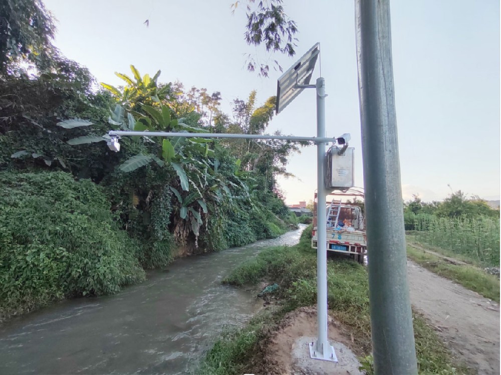
NiuBoL automated hydrological monitoring station is not a single-function detection point but a comprehensive infrastructure with extremely strong scalability.
Water Quality Monitoring Module Integration: Can access pH value, dissolved oxygen, ammonia nitrogen, turbidity, and other sensors as needed. This is crucial for irrigation area basin ecological monitoring systems, real-time grasping river “health status.”
Meteorological Environment Expansion: Can add wind direction, wind speed, air temperature humidity, and pressure monitoring, providing multi-dimensional reference for basin meteorological analysis.
This integrated design greatly improves monitoring efficiency, ensuring data accuracy and real-time, providing scientific basis for rational use and protection of water resources.
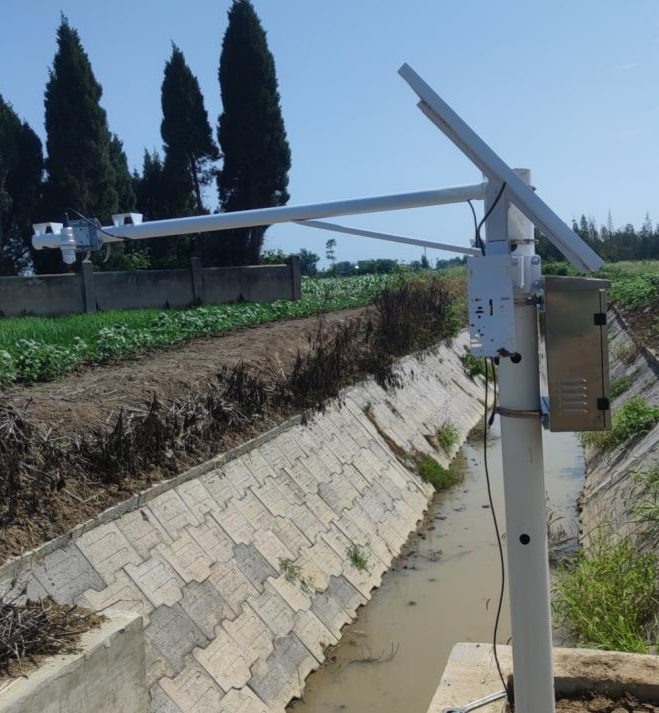
Telemetry stations are usually set in remote areas with inconvenient power supply and harsh natural environments. NiuBoL places “energy saving” and “stability” at the forefront in system design.
Ultimate Energy Efficiency Optimization
System adopts intelligent power management logic. RTU enters deep sleep in non-acquisition stages with extremely low current consumption. Communication module activates only in set reporting cycles or triggered alarms (such as sudden water level changes). Due to extremely short transmission time each time, overall system energy consumption compressed to extreme.
Scientific Ratio of Solar and Battery
Based on local sunshine hours and equipment power consumption, NiuBoL equips each monitoring station with customized power system:
Solar Charging: Adopts monocrystalline silicon panels maintaining certain charging efficiency even in weak light environments.
Intelligent Battery Pack: With overcharge/overdischarge protection and wide temperature operation characteristics, ensuring monitoring station stable operation in continuous multi-day rainy weather.
Urban Flood Control and Drainage Warning
Deploy monitoring stations in urban low-lying areas and underpasses; through NiuBoL system real-time monitoring water accumulation levels and linking with municipal drainage pump stations, significantly shortening response time, protecting citizen life and property safety.
Irrigation Area Water Resource Quota Management
In large irrigation areas, hydrological stations provide precise diversion and drainage data. This is not only basis for fair water fee collection but also technical support for promoting water-saving irrigation and optimizing water resource allocation.
River Chief System and Water Administration Supervision
As important link in river chief system informatization, automated monitoring stations provide objective and impartial third-party data, helping management departments real-time grasp water level fluctuations and ecological changes in responsible river sections, enhancing scientific water administration supervision.
Q1: Will radar water level gauge data jump in large wind and waves?
A: NiuBoL's algorithm has built-in smoothing filtering processing. System continuously collects multiple raw samples, filters instantaneous fluctuations caused by wind and waves through mean calculation and outlier removal, outputting stable water level data.
Q2: What if monitoring station installed in deep mountain valleys without mobile signal?
A: For such special environments, we can configure Beidou satellite communication module for NiuBoL RTU. Data directly transmitted through satellite link, ensuring monitoring “zero blind spots.”
Q3: How is equipment protection against lightning and static electricity?
A: All field monitoring equipment has industrial-grade lightning protection design. RTU interfaces have built-in multi-level lightning protection circuits, combined with good grounding system, effectively resisting summer thunderstorm damage to electronic components.
Q4: How to ensure data accuracy? Need frequent calibration?
A: Due to core sensors like radar water level gauge adopting non-contact measurement, no mechanical wear and probe scaling issues, maintenance frequency extremely low. Usually recommend on-site verification once every 12 months.

NiuBoL automated hydrological monitoring station is not only hardware stacking but deep understanding of basin management logic. Through high-precision full-element perception, ultra-low power consumption operation mode, and powerful data integration capability, it builds a solid “digital embankment” for modern water conservancy management.
In water environment management, flood control and disaster reduction, and water resource protection fields, NiuBoL is playing key technical support role, promoting basin management toward smarter and more sustainable direction.
Are you looking for customized design for specific basin flood control projects? We can provide detailed site layout suggestions and equipment configuration lists. Want to know how NiuBoL RTU seamlessly accesses your existing management software platform? Please contact our technical consultants immediately for more detailed technical documents and successful cases.
Related recommendations
Sensors & Weather Stations Catalog
 Agriculture Sensors and Weather Stations Catalog-NiuBoL.pdf
Weather Stations Catalog-NiuBoL.pdf
Agriculture Sensors Catalog-NiuBoL.pdf
Water Quality Sensor Catalog-NiuBoL.pdf
Related products
 Combined air temperature and relative humidity sensor
 Soil Moisture Temperature sensor for irrigation|NBL-S-THR
 Soil pH sensor RS485 soil Testing instrument soil ph meter for agriculture |NBL-S-PH
 Wind Speed sensor Output Modbus/RS485/Analog/0-5V/4-20mA
 Tipping bucket rain gauge for weather monitoring auto rainfall sensor RS485/Outdoor/stainless steel
 Pyranometer Solar Radiation Sensor 4-20mA/RS485

Screenshot, WhatsApp to identify the QR code
WhatsApp number:+8615367865107
(Click on WhatsApp to copy and add friends)
