


— Blogs —
—Products—
 Consumer hotline +8618073152920
 WhatsApp:+8615367865107
Address:Room 102, District D, Houhu Industrial Park, Yuelu District, Changsha City, Hunan Province, China
Product knowledge
Time:2026-03-29 15:42:30 Popularity:354
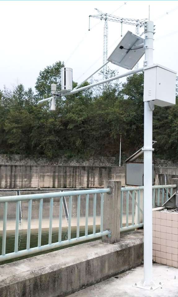
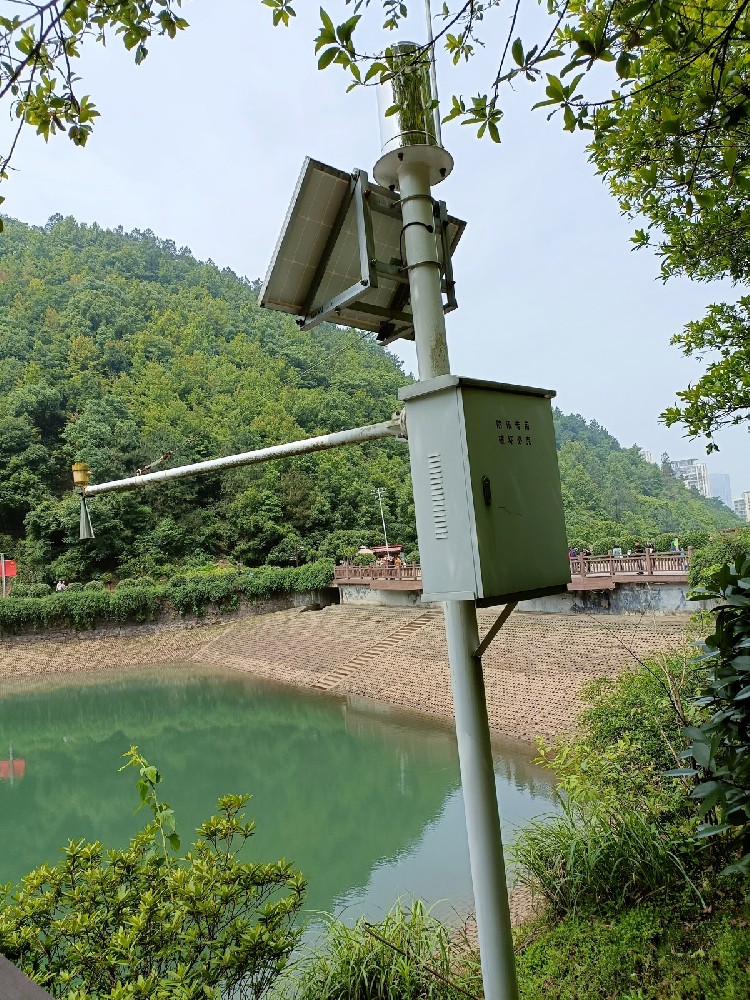
The radar water level and rainfall monitoring system is an important part of water conservancy informatization construction. It realizes real-time monitoring of water level and precipitation in rivers, lakes, reservoirs and other water areas through non-contact FMCW radar technology, providing high-precision data support for flood control decision-making, water resource scheduling and disaster early warning. In China's hydrometeorological observation and forecasting service system, this system significantly improves the response capability under extreme weather, and is especially suitable for complex environments such as mountain flood-prone areas, river channels, reservoirs and wetlands. NiuBoL radar water level and rainfall monitoring system adopts 77GHz~79GHz millimeter wave radar, featuring low power consumption, wide voltage input and water surface fluctuation filtering function, helping system integrators, IoT solution providers, project contractors and engineering companies build a reliable flood control monitoring network.

With the intensification of climate change and the frequent occurrence of extreme precipitation events, floods caused by heavy rain in places such as Henan and Shanxi in China have put forward higher requirements for the accuracy and stability of hydrological monitoring equipment. The radar water level and rainfall monitoring system integrates continuous water level measurement and rainfall monitoring. It is deployed on river and lake banks, dams or around reservoirs. By collecting hydrological and meteorological elements in real time, it provides a data foundation for basin flood control, drought resistance scheduling and water conservancy project planning.
Traditional contact water level gauges are easily affected by water flow impact, sediment deposition, floating objects and corrosion, while the radar system adopts a non-contact measurement method. Radar waves penetrate the air and directly reflect water surface echoes, without being interfered by atmospheric temperature, pressure, wind speed, precipitation or relative humidity. NiuBoL radar water level and rainfall monitoring system specially designs a water surface fluctuation filtering algorithm, which can still output stable data even in turbulent flow or water areas with a large number of floating objects. The system supports solar power supply and unattended field mode, and is suitable for deployment in remote mountain flood channels, wetlands and tidal areas.
In flood control work, the system assists relevant departments to quickly judge flood peak arrival time, submerged range and risk level through online real-time monitoring of water level change trends and combined with rainfall cumulative data, realizing the transformation from passive response to active prevention and control.

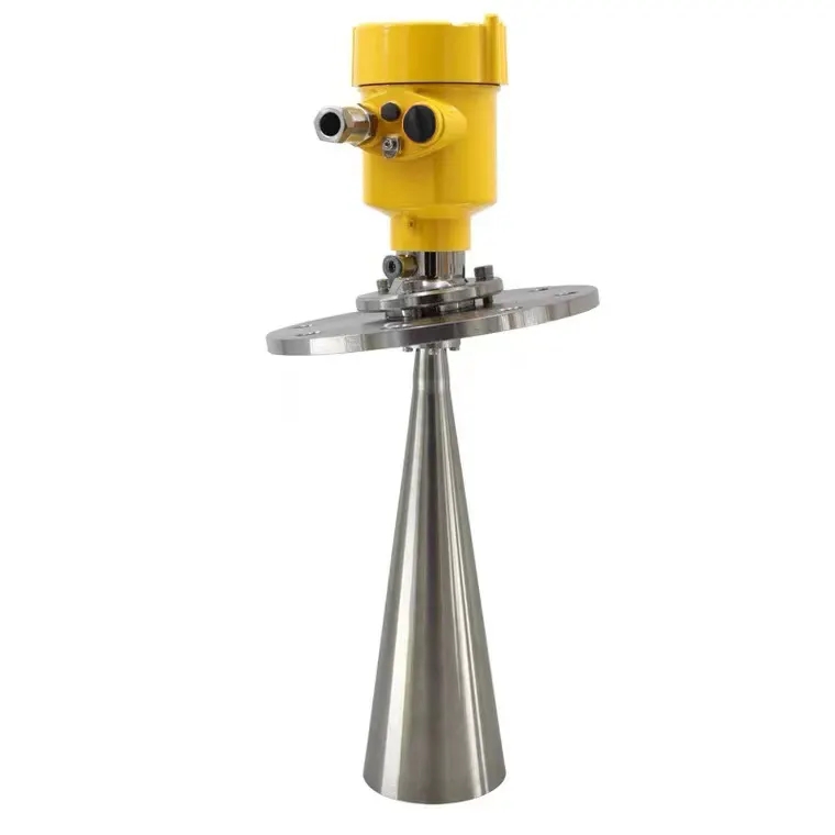
NiuBoL radar water level gauge series products are based on self-developed CMOS millimeter wave RF chips, operating in the 77GHz~79GHz frequency band, using Frequency Modulated Continuous Wave (FMCW) technology. The transmitted signal is a continuous wave with linear frequency modulation. After receiving the water surface reflection echo, the distance is accurately calculated by computing the frequency difference (beat frequency) between the transmitted and echo signals. This principle makes the measurement not significantly affected by drastic changes in the dielectric constant of the medium or surface fluctuations.
Compared with pulse radar, FMCW technology provides higher distance resolution and anti-interference ability. The narrowest 8° antenna beam angle effectively reduces false echoes generated by fixed interference such as river banks, bridges or vegetation. The integrated lens antenna design further compresses the volume, reduces installation difficulty, and achieves a smaller blind zone (within 15cm) and higher signal-to-noise ratio.
The core advantages of the system include:
Non-contact measurement to avoid corrosion or blockage caused by direct contact between the sensor and water body.
Wide range coverage (0.15m~65m), suitable for different scenarios from shallow ditches to large reservoirs.
Low power consumption design (maximum 0.6W), combined with solar power supply system, to achieve long-term stable operation.
Water surface fluctuation filtering processing to ensure data reliability under turbulent conditions.
Maintenance-free characteristics, reducing the frequency of field inspections and lowering overall operation and maintenance costs.
These features make NiuBoL radar water level and rainfall monitoring system particularly suitable for real-time monitoring in places with variable water quality, floating objects or dense aquatic plants, as well as mountain flood-prone areas.
1. The core of flood control lies in timely grasping water level dynamics and rainfall intensity. NiuBoL system integrates radar water level gauge with rainfall sensor, uploads data to the water and rainfall monitoring platform through RS485 or wireless communication protocols, realizing second-level response and historical curve analysis.
2. In river channel and reservoir monitoring, the system tracks water level rise rate in real time. When the water level approaches the warning line, it automatically triggers graded early warning to assist dispatching departments to open flood discharge gates in advance or transfer personnel in low-lying areas. When deployed in mountain flood channels, combined with short-term heavy rainfall data, the platform can calculate confluence time and peak flow to provide advance forecasts for downstream villages.
3. In wetland and tidal area applications, the non-contact feature avoids the failure of traditional equipment in high salinity or silt environments. In open channels and irrigation areas, high-precision data can be used to optimize water resource allocation and reduce waste.
In engineering practice, the system is often linked with video surveillance, flow meters and gate controllers to form a closed-loop flood control system. For example, when the radar water level gauge detects rapid upstream water level rise and cumulative rainfall exceeds the threshold, the platform automatically links downstream gate opening adjustment to balance flood control and water supply needs.
Long-term data accumulation also supports water conservancy project planning. Historical water level sequences and rainfall distribution can be used for dike height verification, bank stabilization project design and sewage discharge capacity assessment, providing scientific basis for basin comprehensive management.

NiuBoL radar water level gauge series are 77GHz~79GHz FMCW radar products with a maximum range of 65m and a blind zone controlled within 15cm. High operating frequency and large bandwidth bring higher measurement resolution and accuracy. The product adopts nut fixing method and is integrated with water and rainfall monitoring poles and hosts, suitable for rapid deployment in various automatic monitoring stations.
| Parameter Name | Technical Index | Remarks |
|---|---|---|
| Power Supply Voltage | DC10-30V | Wide voltage input |
| Maximum Power Consumption | 0.6W | Low power consumption, suitable for solar power supply |
| Transmit Frequency | 77GHz~79GHz | FMCW millimeter wave |
| Measurement Range | 0.15m ~ 65m | Covering shallow water to large water areas |
| Resolution | 1mm | High precision |
| Measurement Accuracy | ±1mm (under 4m, 40%RH, 25℃ conditions) | Typical laboratory value |
| Beam Angle | 8° | Reduce interference |
| Operating Temperature/Humidity | -40℃~+80℃, 0%~95%RH (non-condensing) | Industrial-grade environmental adaptation |
| Communication Protocol | RS485 output | Supports Modbus and other extensions |
| Protection Level | IP67 | Waterproof and dustproof, suitable for field use |
Before installation, check that the delivered equipment includes the radar water level gauge sensor, matching nuts, certificate and warranty card. Confirm the power supply voltage range and communication lines are intact, and prepare necessary poles or brackets.
Installation Steps and Precautions:
Site Selection Principle: Choose open water surface areas to avoid fixed interference objects such as river banks, bridges and trees within the beam range. Maintain sufficient safe distance from potential obstacles.
Installation Posture: Ensure the instrument is perpendicular to the water surface. Tilted installation will weaken the received signal amplitude and affect ranging accuracy.
Height Setting: The reference installation height should have a certain margin above the historical highest water level while meeting blind zone requirements (usually more than 0.3m above the lowest water level).
Beam Management: Adjust the installation position so that the 8° beam angle covers the main water surface and avoid false echoes from side walls or bank reflections.
Electrical Connection: Use shielded cables, ensure good grounding (resistance<4Ω), and configure surge protection devices.
System Debugging: After power-on, perform false echo suppression settings and accuracy verification. Calibrate with professional tools if necessary.
Under typical working conditions, vertical installation on open river sections or in front of reservoir dams can achieve the best measurement results. NiuBoL provides installation guidance services to facilitate rapid implementation by engineering companies.
NiuBoL radar water level and rainfall monitoring system supports integration with rain gauges, soil moisture sensors and other hydrological equipment to form multi-parameter water and rainfall automatic stations. Data is uploaded to the cloud platform via RS485 local output or 4G/NB-IoT wireless, realizing WebGIS visualization, mobile query and automatic alarm push.
For large projects, the system can be deployed in a network and perform local preliminary processing with edge computing nodes to reduce main station pressure. Open communication protocols facilitate secondary development of linkage logic by IoT solution providers, such as automatic linkage of video capture or SMS notification when water level exceeds the limit.
In smart water conservancy construction, the system docks with existing hydrological databases to support historical data comparison analysis and model calibration, further improving flood control forecasting accuracy.

1. What are the advantages of the radar water level and rainfall monitoring system compared to pressure-type water level gauges?
The radar system adopts non-contact FMCW measurement, which is not affected by water impurities, corrosion or fluctuations. Maintenance is significantly reduced and long-term stability is higher.
2. How is the measurement accuracy of NiuBoL radar water level gauge in actual field environments?
It can reach ±1mm under standard conditions. Combined with the water surface fluctuation filtering algorithm, it can still maintain high reliability even in turbulent flow or water areas containing floating objects.
3. Does the system support solar power supply and unattended operation?
Yes. The low power consumption design (0.6W) combined with solar + battery solution is suitable for long-term operation in remote areas without frequent manual intervention.
4. How to avoid false echo interference during installation?
Choose open water surface, ensure no fixed obstacles within the beam angle range, and perform false echo suppression settings through software.
5. Does the communication protocol support docking with mainstream hydrological platforms?
Supports RS485 output and can be extended with protocols such as Modbus RTU, making it easy for system integrators to access existing monitoring networks.
6. What complex water area environments is this system suitable for?
Widely applicable to river channels, reservoirs, open channels, wetlands, tidal areas, ditches with floating objects and places with dense aquatic plants, especially suitable for mountain flood-prone areas.
7. How to use system data for flood control decision-making?
After real-time water level and rainfall data are uploaded to the platform, trend curves, risk levels and early warning information can be generated to assist dispatching departments in formulating schemes such as flood discharge and personnel transfer.
8. What is the product's protection level and environmental adaptability?
IP67 protection level, operating temperature -40℃~+80℃, can withstand harsh field meteorological conditions, with long service life and low maintenance cost.
The radar water level and rainfall monitoring system plays an irreplaceable role in flood control work. It provides a stable and reliable data foundation for hydrological monitoring and disaster prevention and control through high-precision and non-contact FMCW radar measurement technology. NiuBoL radar water level gauge series products meet the actual needs of various water conservancy engineering projects with 77GHz millimeter wave technology, low power consumption design and flexible integration capabilities.
In the context of China's water security strategy, strengthening the construction of hydrological monitoring equipment is a key measure to improve flood control capabilities. Choosing a professional and reliable radar water level and rainfall monitoring solution can not only effectively cope with the challenges brought by extreme weather, but also provide strong support for scientific management of water resources and long-term planning of water conservancy projects.
As a professional manufacturer, NiuBoL is committed to providing system integrators, IoT solution providers, project contractors and engineering companies with complete technical support and customized services. If you need product selection, integration solutions or on-site deployment guidance, please feel free to communicate with the professional team to jointly promote the high-quality development of water conservancy informatization.
Next:Key Role of Radar Hydrological Monitoring Station in Flood and Waterlogging Disaster Prevention
Related recommendations
Sensors & Weather Stations Catalog
 Agriculture Sensors and Weather Stations Catalog-NiuBoL.pdf
Weather Stations Catalog-NiuBoL.pdf
Agriculture Sensors Catalog-NiuBoL.pdf
Water Quality Sensor Catalog-NiuBoL.pdf
Related products
 Combined air temperature and relative humidity sensor
 Soil Moisture Temperature sensor for irrigation|NBL-S-THR
 Soil pH sensor RS485 soil Testing instrument soil ph meter for agriculture |NBL-S-PH
 Wind Speed sensor Output Modbus/RS485/Analog/0-5V/4-20mA
 Tipping bucket rain gauge for weather monitoring auto rainfall sensor RS485/Outdoor/stainless steel
 Pyranometer Solar Radiation Sensor 4-20mA/RS485

Screenshot, WhatsApp to identify the QR code
WhatsApp number:+8615367865107
(Click on WhatsApp to copy and add friends)
