


— Blogs —
—Products—
 Consumer hotline +8618073152920
 WhatsApp:+8615367865107
Address:Room 102, District D, Houhu Industrial Park, Yuelu District, Changsha City, Hunan Province, China
Product knowledge
Time:2026-03-29 15:46:38 Popularity:364
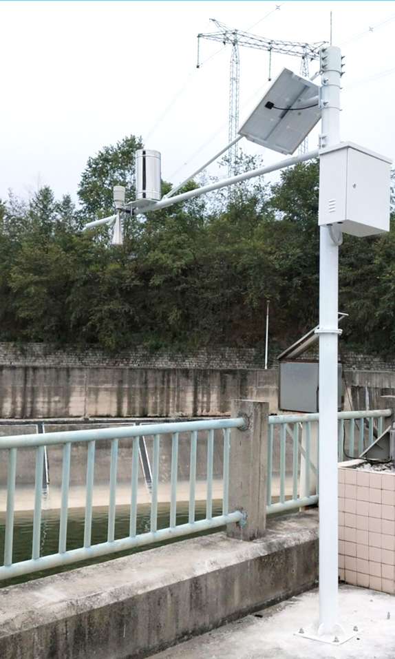
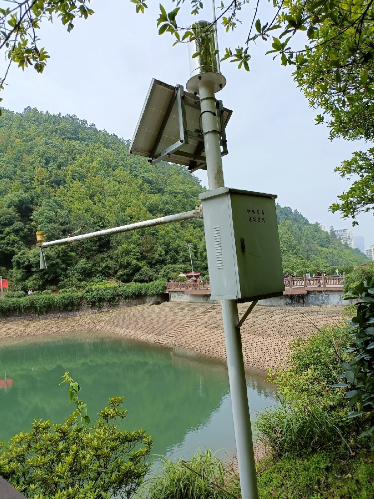
The radar hydrological monitoring station is the core equipment in the water conservancy flood control system for online multi-element monitoring of water level, flow velocity, flow rate and rainfall. It uses non-contact microwave radar technology to provide high-precision real-time data for basin flood forecasting, urban waterlogging warning and water conservancy project scheduling. In the context of frequent flood and waterlogging disasters in China, NiuBoL radar hydrological monitoring station helps system integrators, IoT solution providers, project contractors and engineering companies build a reliable hydrological monitoring network, effectively improving flood analysis, drought prediction and emergency response capabilities.

As one of the countries with the most frequent flood and waterlogging disasters, China's middle and lower reaches plains of the seven major rivers are prone to river flooding and urban waterlogging due to dense population, high urbanization and significant hardening of the underlying surface. Prolonged heavy rain, typhoon activities and concentrated precipitation periods often cause river flow to exceed flood discharge capacity, reservoir and lake storage to exceed limits, and subsequently trigger dike risks and secondary disasters.
The radar hydrological monitoring station provides basic data for joint analysis by hydrological and meteorological departments through real-time collection of key hydrological parameters such as water level, flow velocity, flow rate and rainfall. It supports early, accurate and fast issuance of flood and waterlogging disaster warnings, building the first line of defense for flood fighting and disaster reduction. Compared with traditional manual observation or contact equipment, NiuBoL radar hydrological monitoring station adopts non-contact measurement, which is not affected by sediment, floating objects, pollutants, water surface fluctuations or temperature, realizing all-weather automatic online monitoring and providing reliable basis for water conservancy project scheduling and flood control and drought relief decision-making.
In the current context of climate change, the increase in extreme precipitation events puts higher requirements on the stability, accuracy and unattended capability of hydrological monitoring equipment. NiuBoL hydrological monitoring system is based on microwave technology, integrating K-band planar radar and 77GHz FMCW radar, meeting deployment needs in multiple scenarios such as river channels, lakes, reservoirs, irrigation canals, underground drainage pipe networks and mountain flood channels.

Water level is the core indicator for flood forecasting and flood control decision-making. NiuBoL radar hydrological monitoring station is mainly applied in the following engineering scenarios:
1. River and Lake Main Channel Monitoring
Deployed in middle and lower reaches of rivers and important lakes to track water level rise rate and peak value in real time. When water level approaches the warning level or flow exceeds the designed flood discharge capacity, the system automatically generates trend analysis and risk assessment reports to support dike inspection, personnel transfer and flood discharge scheduling.
2. Reservoir and Gate Scheduling
Installed in front of reservoir dams or at gate positions, combined with rainfall data to calculate inflow and storage changes, providing quantitative support for optimized reservoir scheduling and balancing flood control and beneficial needs.
3. Urban Waterlogging and Underground Drainage Pipe Network Monitoring
For urban river channels, underground pipe networks and drainage ditches, NiuBoL system overcomes the rapid confluence problem caused by hardened ground through non-contact measurement, grasps pipe network water level and flow in real time, and assists linkage control of drainage pump stations to reduce waterlogging time.
4. Mountain Flood Channel and Irrigation Area Emergency Monitoring
Deployed in mountain flood-prone areas and irrigation channels, the system simultaneously monitors water level, flow velocity, flow rate and rainfall, supports short-term forecasting model operation, and provides advance warnings for downstream villages and agricultural areas.
5. Water Conservancy Project Planning and Long-term Management
Accumulation of historical hydrological data provides measured basis for engineering design of bridges, ports, waterways, water supply and drainage, and supports dike reinforcement, bank stabilization projects and sewage discharge capacity assessment.
Compared with traditional water gauge observation, radar hydrological monitoring station realizes unattended, continuous monitoring throughout the whole period, with higher data accuracy and stronger timeliness, which can significantly reduce the safety risks and labor intensity of manual observation.
NiuBoL hydrological online monitoring system is a fully automatic hydrological monitoring platform based on microwave technology, which can simultaneously realize non-contact measurement of water level, flow velocity, flow rate and rainfall in channels. The system adopts advanced K-band planar radar technology and 77GHz FMCW radar, and calculates section flow and cumulative flow in real time through built-in algorithms to output stable and reliable hydrological parameters.
Main functions include:
Non-contact water level and flow velocity measurement, not affected by temperature, sediment, pollutants, floating objects or aquatic plants.
Real-time section flow calculation and cumulative flow statistics, supporting multiple section types.
Integrated rainfall monitoring to form a comprehensive water and rainfall data chain.
Low power consumption design, suitable for solar power supply and unattended field scenarios.
Data uploaded to hydrological monitoring platform via RS485 or wireless protocols, supporting docking with existing SCADA systems.
The system is particularly suitable for complex hydrological conditions such as rivers, lakes, tidal areas, reservoir gates, underground drainage pipe networks and irrigation canals, providing data support for urban water supply, sewage monitoring and flood control early warning.

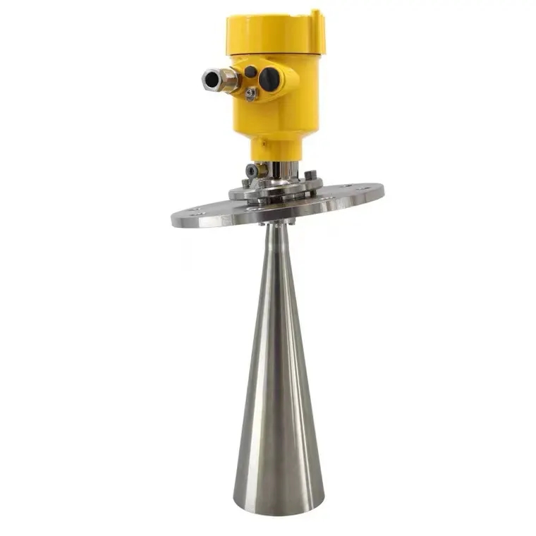
NiuBoL radar water level gauge series products operate in the 77GHz~79GHz frequency band, using Frequency Modulated Continuous Wave (FMCW) technology, with a maximum range of 65m and a blind zone controlled within 15cm. The high-frequency band and large bandwidth design bring higher measurement resolution and accuracy. The product adopts nut fixing method, which is convenient for integration with water and rainfall monitoring poles and hosts, and is suitable for rapid deployment in various automatic stations.
| Parameter Name | Technical Index | Remarks |
|---|---|---|
| Power Supply Voltage | DC10-30V | Wide voltage input, suitable for various power supplies |
| Maximum Power Consumption | 0.6W | Low power consumption, suitable for solar power supply |
| Transmit Frequency | 77GHz~79GHz | FMCW millimeter wave radar |
| Measurement Range | 0.15m ~ 65m | Covering shallow channels to large water areas |
| Resolution | 1mm | High resolution |
| Measurement Accuracy | ±1mm (under 4m, 40%RH, 25℃ conditions) | Typical laboratory accuracy |
| Beam Angle | 8° | Strong anti-interference ability |
| Operating Temperature/Humidity | -40℃~+80℃, 0%~95%RH (non-condensing) | Industrial-grade environmental adaptability |
| Communication Protocol | RS485 output | Supports Modbus RTU and other extensions |
| Protection Level | IP67 | Waterproof and dustproof, long-term stability in the field |
Pre-installation Check
The delivered equipment includes the radar water level gauge sensor, matching nuts, certificate and warranty card. Before installation, confirm that the power supply is adapted and the communication interface is normal, and prepare poles or brackets.
Installation Steps and Key Precautions
Site Selection Requirements: Choose open water surface areas to ensure no river banks, bridges or other fixed interference objects within the beam range.
Installation Posture: Strictly ensure the instrument is perpendicular to the water surface. Tilting will weaken the received signal and affect ranging accuracy.
Beam Management: Adjust installation height and angle to avoid the transmitted beam illuminating river banks or obstacles and generating false echoes.
Electrical Protection: Use shielded cables, implement equipotential grounding, and configure surge protection devices.
System Debugging: After power-on, perform false echo suppression settings and on-site accuracy verification.
Correct installation can maximize the measurement performance of the radar hydrological monitoring station and provide stable data output for engineering projects.
NiuBoL radar hydrological monitoring station supports networking with rainfall sensors, flow meters and other hydrological equipment to form a multi-parameter water and rainfall automatic monitoring station. Data can be uploaded to the cloud platform via RS485 local output or 4G/5G wireless, realizing WebGIS display, trend analysis and automatic alarm push.
For large flood control projects, the system can be linked with video surveillance and gate controllers to build a closed-loop emergency response mechanism. Open communication protocols facilitate secondary development by system integrators and IoT solution providers for quick docking with existing water conservancy informatization platforms.

1. What is the main advantage of radar hydrological monitoring station compared with traditional contact water level gauges?
It adopts non-contact microwave radar measurement, which is not affected by sediment, floating objects or pollutants. It has low maintenance and higher long-term stability.
2. Can NiuBoL hydrological monitoring system measure water level, flow velocity, flow rate and rainfall simultaneously?
Yes. The system integrates K-band planar radar and FMCW radar technology to synchronously output multi-element hydrological data.
3. Is the system suitable for urban underground drainage pipe network monitoring?
Yes. The non-contact measurement feature enables it to effectively cope with the complex environment of underground pipe networks and provide data support for waterlogging warning.
4. How is the measurement accuracy of the radar water level gauge guaranteed in actual field applications?
The accuracy reaches ±1mm under standard conditions. Combined with the water surface fluctuation filtering algorithm, it can maintain high reliability in turbulent flow and complex water areas.
5. Does the system power consumption support solar power supply and unattended operation?
Yes. The maximum power consumption is only 0.6W. The low power consumption design is very suitable for field automatic stations powered by solar + battery.
6. What technical points need the most attention during installation?
Ensure the instrument is perpendicular to the water surface and there are no fixed interference objects within the beam range to avoid false echoes.
7. Is the communication protocol convenient for integration with existing hydrological platforms?
Supports RS485 output and can be extended with protocols such as Modbus RTU, which is convenient for system integrators to quickly dock.
8. What typical flood control engineering scenarios is this system suitable for?
Widely applicable to rivers, lakes, reservoirs, irrigation canals, underground drainage pipe networks, mountain flood channels and urban waterlogging monitoring projects.
The radar hydrological monitoring station plays a fundamental supporting role in flood and waterlogging disaster prevention. It provides reliable data for flood control early warning, water conservancy scheduling and emergency decision-making through high-precision and non-contact online monitoring of water level, flow velocity, flow rate and rainfall. NiuBoL hydrological online monitoring system meets the actual needs of various water conservancy engineering projects with 77GHz FMCW radar technology, low power consumption design and flexible integration capabilities.
Facing the challenges of extreme hydrological events brought by climate change, choosing a professional and reliable radar hydrological monitoring solution helps system integrators, project contractors and engineering companies improve project delivery quality and operation and maintenance efficiency, and jointly build a more resilient flood control system.
As a professional hydrological equipment manufacturer, NiuBoL focuses on providing industry partners with technically mature and performance-stable monitoring products and integration support. If you need product selection, system solution design or on-site deployment guidance, please feel free to contact the professional team for further cooperation.
Related recommendations
Sensors & Weather Stations Catalog
 Agriculture Sensors and Weather Stations Catalog-NiuBoL.pdf
Weather Stations Catalog-NiuBoL.pdf
Agriculture Sensors Catalog-NiuBoL.pdf
Water Quality Sensor Catalog-NiuBoL.pdf
Related products
 Combined air temperature and relative humidity sensor
 Soil Moisture Temperature sensor for irrigation|NBL-S-THR
 Soil pH sensor RS485 soil Testing instrument soil ph meter for agriculture |NBL-S-PH
 Wind Speed sensor Output Modbus/RS485/Analog/0-5V/4-20mA
 Tipping bucket rain gauge for weather monitoring auto rainfall sensor RS485/Outdoor/stainless steel
 Pyranometer Solar Radiation Sensor 4-20mA/RS485

Screenshot, WhatsApp to identify the QR code
WhatsApp number:+8615367865107
(Click on WhatsApp to copy and add friends)
