


— Blogs —
—Products—
 Consumer hotline +8618073152920
 WhatsApp:+8615367865107
Address:Room 102, District D, Houhu Industrial Park, Yuelu District, Changsha City, Hunan Province, China
Product knowledge
Time:2025-12-17 13:38:14 Popularity:669
Climate change and water resource shortages are two major challenges facing contemporary society. The key hub connecting weather changes and water body cycles is the hydrometeorological station. They act like the “eyes” and “nervous system” of the natural environment, continuously recording and analyzing atmospheric and water body data, providing crucial information for human survival, development, and disaster prevention and mitigation.
The importance of hydrometeorological stations far exceeds daily weather forecasting; they are the foundational tools for formulating national flood control strategies, optimizing agricultural production, and advancing sustainable water resource management.

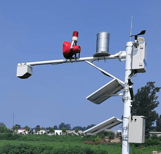
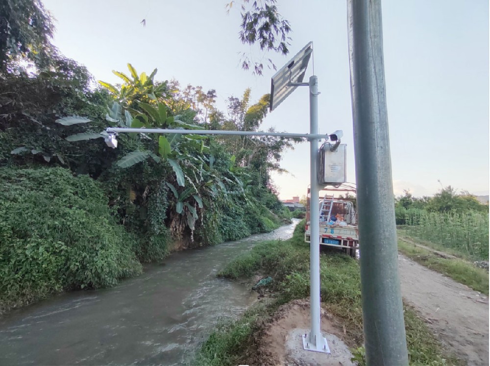
A hydrometeorological station is an automated device integrating multiple sensors, specifically used for measuring, recording, and analyzing data related to atmospheric meteorology and water body hydrology. It is usually installed in rivers, lakes, reservoirs, farmlands, or remote mountainous areas for continuous, all-weather data collection.
The working principle of hydrometeorological stations is to convert physical quantities in nature (such as temperature, pressure, water level) into electrical signals through a precisely designed sensor array, then send them to the data center via data collectors and transmission systems.
The core of hydrometeorological stations is their multifunctional sensor array:
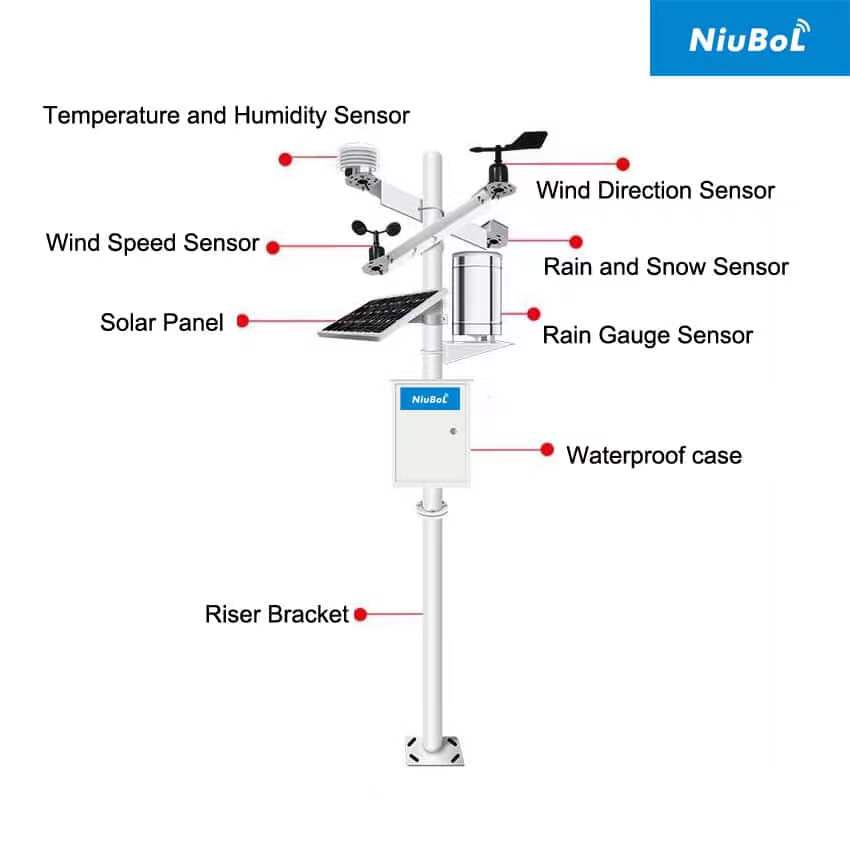
Thermometer/Hygrometer: Measures air temperature and humidity, used for weather forecasting, crop growth models, and comfort assessment.
Barometer: Measures atmospheric pressure, key for judging weather system evolution (e.g., high/low pressure).
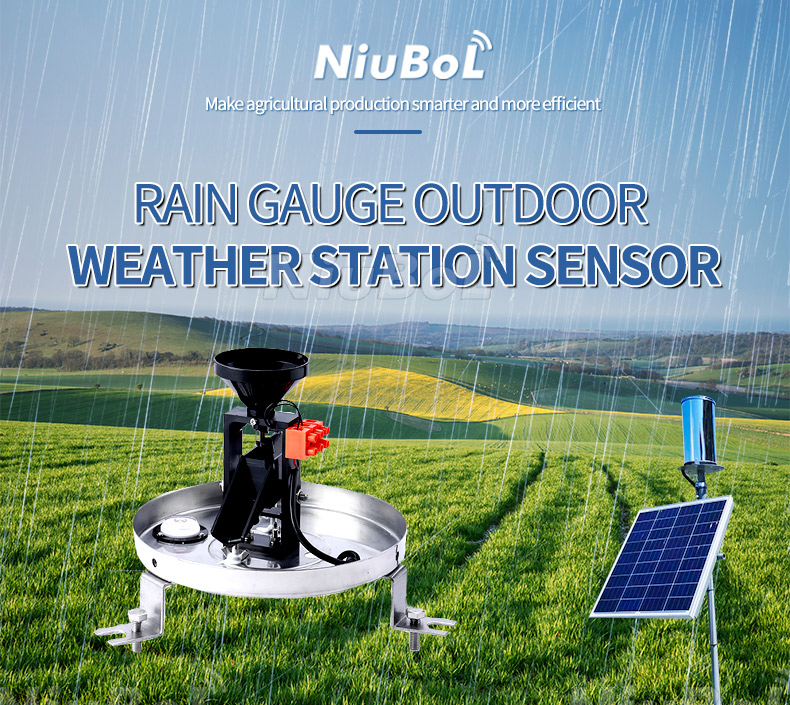
Precipitation Gauge (Rain Gauge): Measures precipitation amount and intensity, directly related to surface runoff and flood risk.
Anemometer/Wind Vane: Measures wind speed and direction, used for forecasting severe convective weather, assessing wind energy resources, and pollutant diffusion.
Water Level Gauge: Measures water level in rivers, lakes, or reservoirs or groundwater depth, core data for flood warning and water resource scheduling.
Flow Meter (usually combined with water level gauge): Indirectly or directly measures water body flow speed and discharge, used for water resource balance calculation and hydropower station operation.
Raw data collected by sensors is processed, stored, and preliminarily calibrated by on-site data collectors/microprocessors. Subsequently, data is transmitted in real time to central databases or cloud platforms via wired (e.g., optical fiber) or wireless (e.g., 4G/LoRaWAN or satellite) systems for further analysis and modeling by meteorologists and hydrologists.

Data provided by hydrometeorological stations is a strategic resource for social stability, economic development, and environmental protection.
Hydrometeorological stations are the foundation of flood warning systems. By real-time monitoring precipitation and upstream river water levels, stations provide early warnings to government departments, gaining valuable evacuation time and minimizing losses from natural disasters like floods and heavy rain.
Hydrological data (water level, discharge) is the “ledger” of water resources. Data from hydrometeorological stations provides important basis for water resource management, including:
Reservoir Scheduling: Helps hydropower stations and reservoir managers determine optimal release and storage timing, balancing flood control, power generation, and water supply needs.
Irrigation Planning: Precisely guides agricultural irrigation water use, avoiding over-irrigation and conserving precious water resources.
In agriculture, meteorological data helps farmers determine optimal sowing, fertilization, and irrigation timing, improving crop yield and quality. In the energy industry, meteorological and hydrological data are important inputs for hydropower generation forecasting and scheduling.
Applications of hydrometeorological stations have penetrated all aspects of society, especially with the development of automation and IoT technology, expanding their scope.
Smart Agriculture and Aquaculture: Real-time environmental data enables precise irrigation and greenhouse control, providing underlying data support for NiuBoL and other smart agriculture solutions.
Urban Planning and Drainage: Urban heavy rain data and waterlogging point monitoring help planners design and optimize drainage systems, improving urban flood control capacity.
Environmental Monitoring and Climate Research: Long-term, continuous data collection provides key observation datasets for scientists to study climate change trends, assess environmental pollution levels, and build complex climate models.
Transportation: Provides visibility, wind force, and other data to ensure safe operation of aviation, navigation, and highways.
The development of modern hydrometeorological stations benefits from deep integration of sensor and information technologies.
High Precision and Stability: New sensors (e.g., ultrasonic water level gauges, laser rain gauges, solid-state wind sensors) improve data precision and stability, reducing drift and calibration needs.
Automation and Remote Control: Automation reduces on-site manual intervention; all equipment can be remotely diagnosed and controlled, greatly improving operational efficiency.
Low Power Consumption Design: Combined with solar power and low-power communication technologies (e.g., LoRaWAN), stations can be deployed in remote areas with insufficient power supply.
Massive data collected by hydrometeorological stations is used to build complex mathematical models. By analyzing correlations between different meteorological and hydrological elements, scientists can perform:
Refined Weather Forecasting: Improve local area forecast accuracy.
Flood Runoff Forecasting: Combined with basin models, predict future water level rise amplitude and timing from rainfall.
Climate Trend Research: Long-term datasets are the foundation for understanding and predicting global climate change.
The reliability of hydrometeorological stations directly depends on maintenance and selection.
Installation Standardization: Site selection must meet regulatory requirements, ensuring sensors are unaffected by surrounding obstacles (e.g., buildings, trees) for data representativeness. Water level sensors use submersible or non-contact installation for firmness and stability.
Regular Calibration: Despite improved sensor precision, key sensors (e.g., rain gauges, water level gauges) still need periodic calibration for data accuracy.
Routine Inspection: Check power supply system (solar panels, batteries), data transmission links, and sensor surfaces for dirt or bird droppings, keeping them clean and functional.
When purchasing hydrometeorological stations, users should focus on:
Monitoring Objectives: Determine required parameters based on application scenarios (e.g., reservoirs, farmlands, cities) — rainfall and water level only, or full meteorological parameters.
Sensor Quality: Prioritize high-precision, high-stability industrial-grade sensors (e.g., NiuBoL products) for long-term reliability.
Protection Level and Material: Consider housing material (e.g., 316L stainless steel) and protection level (e.g., IP68) for harsh field environments.
Communication Compatibility: Ensure data collectors support common protocols (e.g., Modbus/RTU) and flexible transmission methods (e.g., 4G/LoRaWAN) for easy integration with existing platforms.
Hydrometeorological stations are key infrastructure for humans to understand the environment and coexist harmoniously with nature. They not only provide real-time warnings for safe social operation but also are important engines for promoting environmental protection and sustainable water resource utilization.
In today's rapidly advancing technology, hydrometeorological stations are becoming more intelligent, efficient, and integrated. Investments by companies like NiuBoL in smart environmental monitoring will continue to optimize station performance, providing a more solid data foundation for global water resource management and climate adaptation strategies.
Q1: How often is data updated from hydrometeorological stations?
A1: Modern automated hydrometeorological stations are usually set for real-time or near-real-time updates, with common data collection frequencies of every 5 minutes, 15 minutes, or 1 hour, then immediately uploaded to the data center via wireless networks. In emergencies like floods or heavy rain, collection and transmission frequency may be set higher, e.g., every 1 minute, for timely warnings.
Q2: What are the main power supply methods for hydrometeorological stations?
A2: Since many hydrometeorological stations are deployed in remote field environments, the main power supply is solar panels combined with batteries. This design uses solar charging, with batteries ensuring stable operation at night or in rainy weather for 24-hour continuous monitoring.
Q3: What long-term research can data from hydrometeorological stations be used for?
A3: Long-term accumulated hydrometeorological data is irreplaceable foundational data for climate change research, regional water cycle model establishment, extreme weather event frequency analysis, and assessing human activities (e.g., urbanization, vegetation changes) on hydrological impacts.
Prev:Smart Aquaculture: Key Water Quality Sensor Technologies and NiuBoL Product Solutions
Next:Hydrological and Water Conservancy Monitoring: Principles and Applications of Four Mainstream Sensor
Related recommendations
Sensors & Weather Stations Catalog
 Agriculture Sensors and Weather Stations Catalog-NiuBoL.pdf
Weather Stations Catalog-NiuBoL.pdf
Agriculture Sensors Catalog-NiuBoL.pdf
Water Quality Sensor Catalog-NiuBoL.pdf
Related products
 Combined air temperature and relative humidity sensor
 Soil Moisture Temperature sensor for irrigation|NBL-S-THR
 Soil pH sensor RS485 soil Testing instrument soil ph meter for agriculture |NBL-S-PH
 Wind Speed sensor Output Modbus/RS485/Analog/0-5V/4-20mA
 Tipping bucket rain gauge for weather monitoring auto rainfall sensor RS485/Outdoor/stainless steel
 Pyranometer Solar Radiation Sensor 4-20mA/RS485

Screenshot, WhatsApp to identify the QR code
WhatsApp number:+8615367865107
(Click on WhatsApp to copy and add friends)
