


— Blogs —
—Products—
 Consumer hotline +8618073152920
 WhatsApp:+8615367865107
Address:Room 102, District D, Houhu Industrial Park, Yuelu District, Changsha City, Hunan Province, China
Product knowledge
Time:2026-01-09 17:01:14 Popularity:621
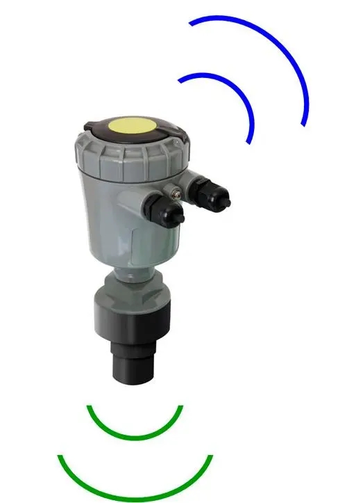
In the process of dealing with extreme weather and river floods, precise hydrological data is the cornerstone of all decisions. Traditional manual measurements or contact devices often lead to equipment damage or data distortion due to sharp rises in water levels or impacts from floating objects. NiuBoL radar flowmeter adopts microwave radar technology to achieve non-contact collection of flow velocity, water level, and flow, unafraid of impurity interference, and is the core unit of modern smart water conservancy monitoring stations.
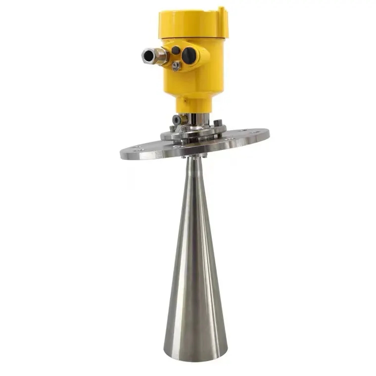
The radar flowmeter mainly consists of a radar flow velocity meter, radar water level gauge, and flow calculation controller. By emitting radar waves and receiving echoes reflected from the water surface, it uses the Doppler effect to calculate flow velocity, while measuring water level through the time-of-flight (ToF) principle, and finally converts to flow in real time based on cross-section parameters.

The accuracy of flow measurement results is often determined at the site selection stage. An ideal flow measurement point should have three major characteristics: "smooth, stable, clean."
1. Hydraulic Condition Requirements
Smooth and Stable: The monitoring channel section should be kept as straight as possible, avoiding deployment near sharp bends, confluences, or diversions. A straight channel section ensures concentrated and stable flow.
Regular Cross-Section: It is recommended to monitor in hardened channels or regular river cross-sections. Regular cross-section geometric parameters (such as bottom width, slope ratio) help improve the accuracy of flow calculation models.
No Interference Flow State: There should be no huge boulders blocking water in the channel section, avoiding huge vortices, turbulence, or severe waterfalls.
2. Environmental Maintenance and Smoothness
The monitoring point should be kept smooth to prevent long-term accumulation of household garbage or branches and other floating objects. Although radar waves have certain penetration and recognition capabilities, severe accumulations will change surface flow velocity characteristics, thereby affecting overall monitoring effects.
In actual construction, installation details directly affect the sensor's perception capability. The following are the core installation points summarized by the NiuBoL technical team.
1. Sensor Orientation and Obstruction Avoidance
Unobstructed Monitoring: There must be no obstructions (such as beams, cables, or branches) in the beam path of the water level gauge and flow velocity meter. Obstructions will cause premature reflection of radar waves, producing false echoes.
Flow Velocity Meter Orientation: The beam of the flow velocity meter is recommended to face the "incoming water direction," that is, directly facing the direction of water flow. During installation, ensure the upper surface of the housing remains level, usually recommended to install on the central axis of the channel to capture the most representative central flow velocity.
2. Height and Range Control
Golden Height: Recommended installation height within 3-4 meters from the water surface. Although the range of NiuBoL radar water level gauge can reach 10 meters or higher, installation at 3-4 meters height can obtain the best signal-to-noise ratio.
Illumination Range Management: When selecting the position, ensure the radar wave illumination range covers the entire water surface. Try to avoid partial or full coverage of the radar wave on the riverbank land during low water levels or dry riverbeds, otherwise invalid static target data will be introduced.
3. Leveling and Electrostatic Protection
During installation, the radar face of the water level gauge must remain strictly parallel to the water surface. Construction personnel can use a level or hanging plumb line for fine adjustment. In addition, since radar is precision electronic equipment, ESD electrostatic protection measures must be taken at all stages of storage, handling, and testing to avoid inductive electricity damaging core chips.
A monitoring station that can serve for many years must consider not only the current installation but also the long-term operating environment.
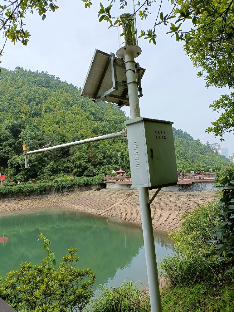
Spatial Capture: The monitoring point surroundings should ensure more than 270° of capture space. If close to buildings, at least 180° of free space should be retained to reduce multipath reflection interference.
Power and Network: The monitoring point should select places with sufficient sunlight (sunshine time recommended above 6 hours) to supply power through solar panels and batteries. At the same time, the site must have stable 4G/5G signals.
Environmental Stability: Avoid strong electromagnetic interference sources (such as high-voltage substations) and strong vibration sources. There should be no fixed pollution sources within 50 meters near the monitoring point to ensure the physical safety of the equipment.
Standardized construction is the guarantee for long-term efficient operation of the equipment.
1. Foundation Pre-Embedding
The monitoring pole foundation pre-embedding pit size is usually 100cm* 100cm*100cm. The pre-embedding pit should align with due south and north for convenient solar panel facing due south. Fill with concrete (cement to sand ratio 1:3) to slightly above ground level, and air dry for about 3 days to ensure complete solidification.
2. Equipment Mounting
Height Layout: The equipment bracket is usually fixed at about 3 meters on the monitoring pole.
Energy Configuration: The solar panel needs to be tilted at 45° and face due south to obtain the highest energy conversion efficiency.
Line Protection: Cable joints must be firm and reliable, with waterproof insulation treatment, strictly prohibiting direct exposure of bare cables in vulnerable positions.
3. Safety and Environmental Construction
During construction, warning signs should be set up, and when hoisting the monitoring pole, safety ropes must be tied to maintain posture stability. Generated waste must be transported to designated places, strictly prohibiting discharge of construction wastewater into natural water sources causing secondary pollution.

Q1: Why does the flow velocity meter need to face the incoming water direction, can it face backwards?
A: Facing the incoming water direction (upstream installation) can obtain more stable Doppler shift signals and is less affected by water surface fluctuations. Backward installation can also measure, but in high flow velocities, it is prone to backwater vortices, leading to increased measurement data fluctuations.
Q2: If there are weeds on both sides of the river, will it affect flow velocity measurement?
A: The radar flow velocity meter is mainly affected by dynamic targets. If the channel is hardened and without huge debris, even if the beam edge illuminates the hardened walls on both sides of the channel, since they are static, the algorithm will automatically filter out these echoes. But if weeds sway violently with the wind, it may cause interference, so it is recommended to keep the channel section clean.
Q3: Can the radar flowmeter monitor non-full pipe culverts?
A: Yes. As long as the radar wave can cover the water surface and there is sufficient space to install the cantilever, the radar flowmeter is an ideal choice for monitoring culverts, sewage outlets, and non-full pipe water flows.
Q4: If the monitoring channel section cannot be completely straight, or there is certain backwater or reverse flow, can the radar flowmeter still measure accurately?
A: In such complex environments, single-point flow velocity measurement often cannot represent the cross-section average flow velocity. NiuBoL recommends the following measures:
1. Multi-point Correction: Establish flow velocity distribution models (flow velocity coefficient correction) under different water levels through manual comparison measurements;
2. Monitoring Direction Adjustment: Ensure the radar flow velocity meter faces the main flow direction, and use the cloud platform's flow calculation algorithm for backwater elimination. If reverse flow is frequent, the system supports "bidirectional flow velocity monitoring" logic, accurately calculating net flow by identifying the positive and negative directions of Doppler shift.
Q5: Will radar waves be interfered by water surface ripples caused by rainfall or strong winds? How to ensure data authenticity in severe weather?
A: This is a common pain point of non-contact measurement. NiuBoL radar flowmeter has built-in vertical vibration compensation and digital filtering algorithms. The system will automatically filter out high-frequency noise from raindrop impacts on the water surface, as well as false fluctuation signals caused by wind and waves. The algorithm can extract the true body flow velocity characteristic values under the water surface. In addition, it is recommended to add wind baffles or select wind-sheltered channel sections during installation, ensuring stable and reliable hydrological curves are transmitted back even in extreme flood prevention weather such as typhoons and heavy rains through a combination of software and hardware.
River flood prevention is a systematic project that requires dual drives of "engineering measures" and "non-engineering measures."
In engineering, building embankments, inspecting pipe surges, and clearing silt are hard strengths; in non-engineering measures, the perception network composed of NiuBoL radar water level gauges, rainfall monitoring stations, and flow velocity meters is soft strength. Through water level telemetry terminals using 4G/5G networks to transmit water conditions in real time to the center, we can provide precious evacuation time for residents along the shore.
From propeller flow velocity meters to radar non-contact flow measurement, each iteration of technology enhances human control over nature. Standardized installation and scientific deployment make every set of hydrological data a solid defense line for safeguarding safety.
Do you need exclusive cantilever design drawings and flow calculation algorithm support for specific rivers (such as mountain rapids or urban landscape rivers)? Welcome to contact NiuBoL and its technical team; we will provide you with a full set of smart water conservancy solutions from on-site surveys to system commissioning.
Prev:NiuBoL Automatic Pest Monitoring Lamp's Operation and Maintenance Manual and Technical Advantages
Related recommendations
Sensors & Weather Stations Catalog
 Agriculture Sensors and Weather Stations Catalog-NiuBoL.pdf
Weather Stations Catalog-NiuBoL.pdf
Agriculture Sensors Catalog-NiuBoL.pdf
Water Quality Sensor Catalog-NiuBoL.pdf
Related products
 Combined air temperature and relative humidity sensor
 Soil Moisture Temperature sensor for irrigation|NBL-S-THR
 Soil pH sensor RS485 soil Testing instrument soil ph meter for agriculture |NBL-S-PH
 Wind Speed sensor Output Modbus/RS485/Analog/0-5V/4-20mA
 Tipping bucket rain gauge for weather monitoring auto rainfall sensor RS485/Outdoor/stainless steel
 Pyranometer Solar Radiation Sensor 4-20mA/RS485

Screenshot, WhatsApp to identify the QR code
WhatsApp number:+8615367865107
(Click on WhatsApp to copy and add friends)
