


— Blogs —
—Products—
 Consumer hotline +8618073152920
 WhatsApp:+8615367865107
Address:Room 102, District D, Houhu Industrial Park, Yuelu District, Changsha City, Hunan Province, China
Product knowledge
Time:2026-03-04 10:03:03 Popularity:541
In the precision agriculture value chain, direct perception of the crop root zone environment is the last and most critical link to achieving “precision”. Air meteorological data depicts macroscopic environmental stress, while soil moisture (water content and temperature) data directly reveals the actual micro-environment state of crop roots, serving as the most direct physiological basis for guiding core farming operations such as irrigation, fertilization, and sowing. Traditional point measurement and manual measurement methods can no longer meet the needs of large-scale and refined management.
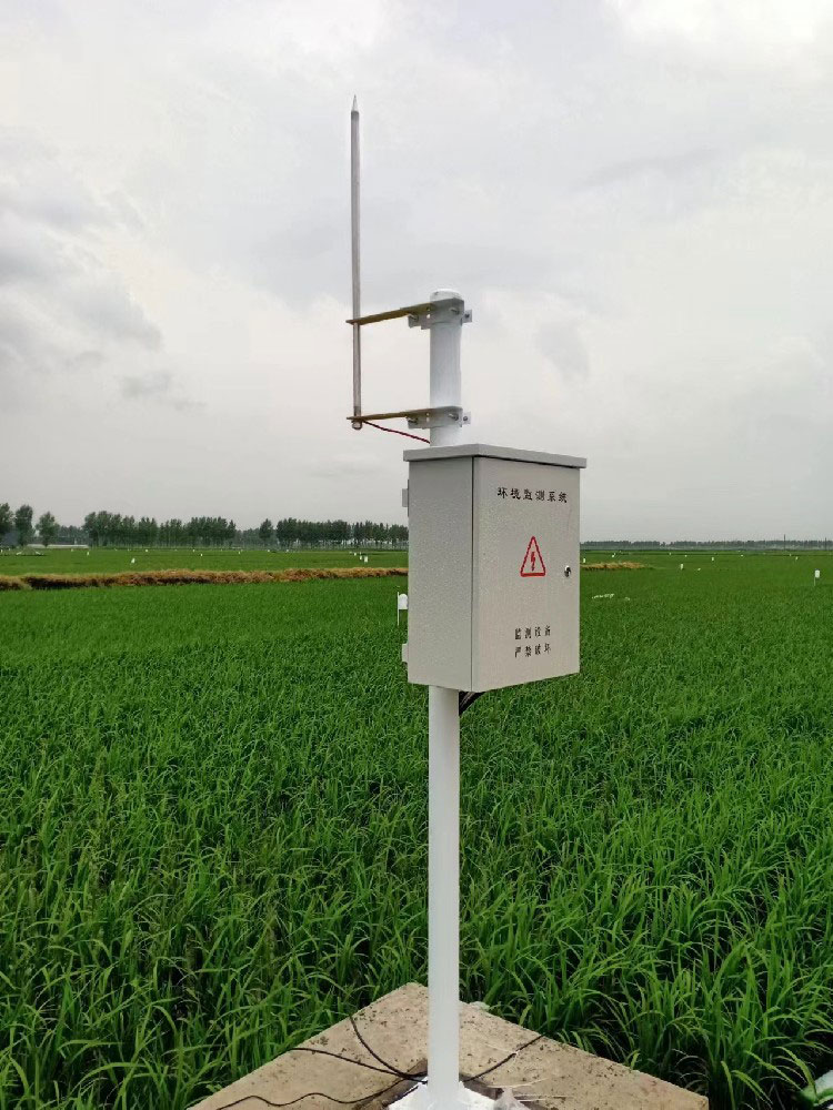
Therefore, deploying an automated, networked, and highly reliable soil moisture monitoring system has become standard infrastructure for modern large farms, high-standard farmlands, and agricultural technology projects. For system integrators, IoT solution providers, and engineering contractors, the construction of this system goes far beyond simple sensor procurement and installation. It involves scientific selection of multi-level sensors, reliable networking in complex field environments, deep protocol docking with existing irrigation/agricultural control systems, and governance and application of massive spatiotemporal data — it is a typical turnkey system engineering project.
Leveraging its deep accumulation in industrial-grade environmental monitoring, NiuBoL provides not only high-precision sensor hardware verified in harsh field environments but also a complete, open, and seamlessly integrable soil data collection and transmission solution into your overall smart agriculture architecture. This article aims to provide you with references from technical selection to project implementation.
Soil volumetric water content (VWC) data is the most core and reliable signal for triggering and stopping irrigation. Compared to evapotranspiration (ETc) calculated solely based on meteorological data, measured soil moisture values can directly feedback irrigation effects and correct prediction deviations caused by uneven soil texture, infiltration differences, etc. Integration logic includes:
Threshold Control: When moisture in a certain layer falls below the lower limit of suitable crop growth range, automatically trigger irrigation command; stop automatically when reaching the upper limit to prevent over-irrigation.
Profile Analysis: Use multi-layer (e.g., 10cm, 20cm, 40cm) data to determine whether irrigation water has infiltrated to the target root layer and optimize single irrigation duration.
Deficit Irrigation Strategy: During specific crop growth stages (e.g., fruit expansion period), deliberately maintain soil moisture at mild stress levels to significantly improve water use efficiency while ensuring yield; this strategy must rely on continuous and precise soil moisture data.
Sowing Decision: Soil temperature is a key factor in determining sowing timing and predicting emergence rates. Monitoring 5-10cm ground temperature can scientifically guide spring sowing.
Frost and Cold Damage Warning: Real-time monitoring of surface and root layer soil temperature to predict frost damage risk to crop roots.
Salinization and Nutrient Migration Monitoring: Combined soil moisture and electrical conductivity (EC) data to analyze salt migration patterns in soil profiles, guiding salt washing irrigation and fertilization management.
Waterlogging Warning: Continuous high moisture state is a precursor to soil waterlogging and root hypoxia; the system can issue timely alarms.
Continuous, long-term, multi-point soil moisture data serves as valuable ground truth data for validating and improving crop growth models, soil hydrodynamics models, and satellite remote sensing inversion of soil moisture product accuracy.
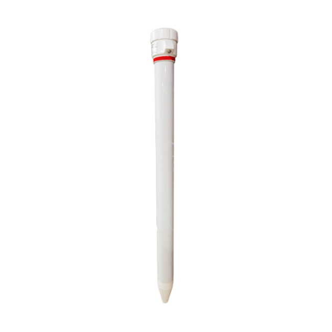
This product represents an engineered, integrated design approach aimed at solving the pain points of complex deployment, poor consistency, and difficult maintenance in traditional distributed sensors.
1. Sensing Principle and Performance Assurance
Moisture Measurement: Uses FDR (Frequency Domain Reflectometry). The sensor emits electromagnetic waves of specific frequency to soil and calculates volumetric water content by measuring changes in resonance frequency (dielectric constant). FDR achieves a good balance between accuracy, stability, and cost, with lower sensitivity to soil salinity than TDR, more suitable for large-area agricultural applications.
Temperature Measurement: Integrated high-precision digital temperature sensor directly contacts soil for more accurate measurement.
Integrated Multi-Layer Design: Multiple sensing units integrated into a sturdy PVC or ABS conduit, preset standard depths (e.g., 10, 20, 30, 40cm). Advantages include:
• Easy Installation: Single drilling completes multi-depth deployment, greatly saving installation time.
• Good Data Correlation: Each layer sensor has unified spatial reference and timestamp, facilitating vertical moisture movement analysis.
• Excellent Protection: Conduit protects sensors from mechanical damage such as farm machinery crushing and insect bites.

2. Key Performance Parameters Detailed
• Soil Volumetric Water Content: Range dry soil to saturated soil; covers almost all agricultural soil conditions.
• Accuracy: ±3% (lab conditions) — key indicator, industry mainstream accuracy sufficient for irrigation decision-making. Note field accuracy affected by soil texture, bulk density, calibration.
• Resolution: 0.1% — can capture subtle moisture changes.
• Soil Temperature: Range -40℃ ~ 80℃ — meets needs of most global agricultural regions, including cold-region agriculture.
• Accuracy: ±0.5℃ — high precision meeting stringent sowing and frost warning requirements.
• Resolution: 0.1℃
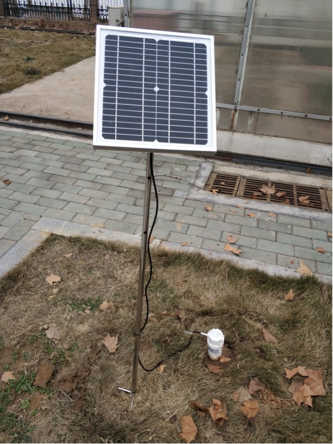
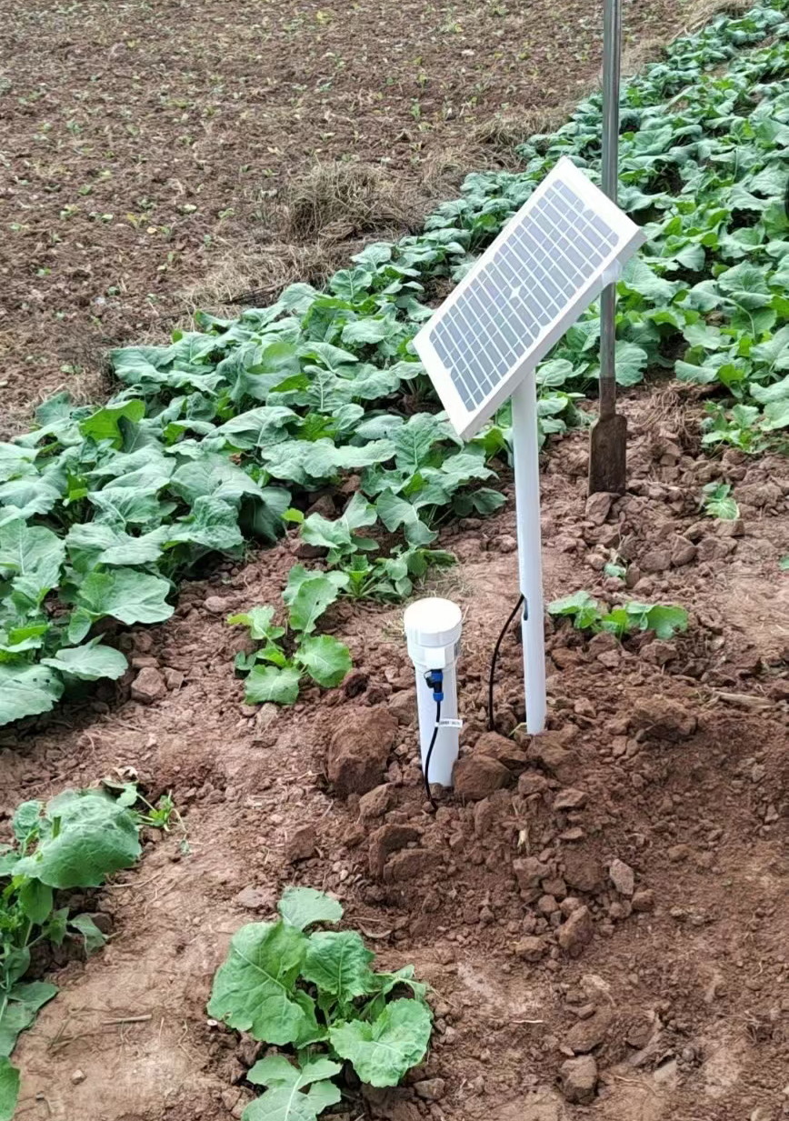
• Power Supply & Consumption: DC12V; sleep<1mA, sampling <70mA — low-power design particularly suitable for solar-powered long-term field monitoring points.
• Output & Communication: RS-485 (Modbus RTU) / 4G wireless — core integration interface. RS-485 for local wired networking, 4G for independent nodes direct to cloud.
• Protection Rating: Above-ground IP67, underground IP68 — ensures long-term immersion in moist soil without leakage, adapting to irrigation and rainy seasons.
• Optional Features: GPS, tilt measurement, vibration alarm — suitable for soil and water conservation, geological disaster monitoring projects. Tilt data can determine if sensor has shifted due to soil subsidence, ensuring data validity.

A single sensor is a neuron; the network architecture is the nervous system. Common deployment architectures include:
Star Centralized (Recommended for Field Monitoring)
Structure: Multiple NBL-S-TMSMS sensors daisy-chained via RS-485 bus, converging to one central data collector (RTU).
Advantages: Relatively regular wiring, unified power supply and management by RTU, high stability. RTU can perform edge computing (e.g., daily average moisture calculation) and upload data via 4G/Ethernet.
Applicable Scenarios: Single monitoring point (representative plot) requiring multiple profiles or different treatment plots.
Distributed Independent (Recommended for Large-Scale Grid Deployment)
Structure: Each NBL-S-TMSMS sensor (or group of 2-3) with built-in 4G communication module and micro solar power system, becoming an independent node.
Advantages: Extremely flexible deployment, no wiring constraints, quick construction of monitoring networks covering hundreds to thousands of acres. Easy to add nodes.
Applicable Scenarios: Large farms, watershed-scale moisture monitoring networks.
Hybrid (Preferred for Large-Scale Projects)
Structure: Star centralized in core demonstration areas for high-density profile data; distributed independent in general monitoring areas for spatial representativeness. All data converges to unified IoT platform via MQTT etc.
Applicable Scenarios: Comprehensive large-scale smart agriculture projects.
Point layout scheme directly affects data representativeness and decision effectiveness. Follow these principles:
Representativeness: Select plots representing main soil types, dominant crops, and typical topography.
Avoid Interference Sources: At least 20-50m from field ridges, ditches, roads, woods to avoid boundary effects and lateral seepage.
Spatial Grid: For uniform large fields, grid layout (e.g., one point per 500 acres). For highly variable fields, stratified random layout based on soil EC maps or historical yield maps, placing points in both high and low yield areas.
Drilling diameter must tightly match conduit to ensure good sensor-soil contact without gaps.
After installation, backfill with original soil and compact to restore natural soil structure.
Record precise GPS coordinates, installation depths, soil types, and other metadata for each point and incorporate into platform database.
This is key to demonstrating system value. Integration modes usually include two types:
Data-Driven (Mainstream): Soil moisture monitoring system as independent data source, pushing real-time data (or irrigation recommendations) to irrigation control platform via MQTT or Modbus TCP. Platform integrates meteorological, crop model etc. data for comprehensive decision-making, then issues commands to field PLCs, pumps, and solenoid valves via control protocols (e.g., Modbus RTU, PROFINET).
Direct Control (Simple Scenarios): In small or independent systems, data collector (RTU) can have built-in simple threshold judgment logic to directly control single solenoid valve open/close via digital output (DO) port. Fast response but simple decision logic.
Integration Development Key Points: Clearly define data interface protocols, refresh rates, alarm message formats between both systems. Usually requires developing a data bridge or middleware service.
Raw data needs transformation into insights. Platform should have:
Real-Time Dashboard: Map display of real-time moisture and temperature status at each monitoring point, color gradient indication.
Historical Curve Analysis: Compare moisture changes at different depths in same location or spatial differences at same depth across locations.
Irrigation Reports: Automatically generate irrigation recommendation reports based on soil moisture, including suggested irrigation timing and estimated water volume.
Mobile Access: Farm owners and agronomists can view data and receive alarms anytime via APP.
Q1. Does FDR sensor measurement accuracy vary greatly with soil texture and salinity? How to calibrate?
A1: Yes, all dielectric method sensors are affected by soil texture (especially clay and organic matter content) and salinity (EC). Factory calibration is based on standard sandy soil. To achieve highest field accuracy, we provide regional soil calibration services: collect undisturbed soil at project site, perform comparative measurements with sensor and oven-dry method in lab, establish localized calibration curve and write to sensor. For most irrigation guidance applications, factory calibration (±3%) is sufficient. We recommend clearly stating calibration type used in project reports.
Q2. If one layer of tubular multi-layer sensor is damaged, does it require overall replacement?
A2: No need for overall replacement. NBL-S-TMSMS multi-layer sensing units adopt modular design. If a specific layer fails, that layer's sensing module can be replaced on-site with professional tools. This greatly reduces long-term maintenance costs.
Q3. In large-scale deployment with hundreds or thousands of 4G sensors uploading simultaneously, how to solve traffic costs and network congestion?
A3: We optimize through intelligent power consumption and data management strategies: 1) Adaptive frequency: Set lower upload frequency (e.g., once per hour) when soil moisture changes slowly (e.g., nighttime), higher when changes are dramatic (e.g., after irrigation). 2) Change reporting: Upload only when data change exceeds set threshold. 3) Data compression and aggregation: Perform simple processing at edge. Through these measures, single node monthly traffic can be controlled within 30MB. Recommend negotiating group IoT card packages with operators to significantly reduce traffic costs.
Q4. How do sensors cope with frozen soil in northern winters? Does freezing affect measurement?
A4: Sensor operating temperature range (-40~80℃) allows physical survival in frozen soil. Note: When soil water freezes, FDR measures “total water content” (ice + unfrozen water), readings remain relatively stable or change slowly, not reflecting true liquid water reduction. This can actually be used to judge freeze-thaw processes. For greenhouses or southern areas still requiring winter irrigation, impact is minimal. We have many successful cases in frozen soil areas, data usable for post-thaw moisture assessment.
Q5. How to ensure NiuBoL soil sensor data smoothly accesses a system integrating multiple vendors' equipment?
A5: We guarantee system openness. All sensors provide standard Modbus RTU over RS-485 protocol documentation with clear register address definitions. Our 4G data terminals support encapsulating data as standard MQTT messages (JSON format) or sending via HTTP POST to specified servers. We can provide data parsing plugins or sample code for common platforms (e.g., ThingsBoard) and arrange technical support for joint debugging to ensure smooth data channels.
Q6. For orchards or hilly land with significant slopes, what special requirements for point layout? What is the use of optional tilt function?
A6: On slopes, moisture redistributes; layout should follow contour lines and distinguish upper, middle, lower slope positions. Tilt sensors are extremely valuable in such scenarios: 1) Installation quality check: Ensure vertical installation. 2) Long-term stability monitoring: Soil creep or landslides may cause sensor tilt; tilt data changes trigger “device displacement” alarm, indicating potential data invalidity requiring on-site verification. This provides hardware-level assurance for data quality.
Q7. What is the system's mean time between failures (MTBF)? What are warranty and calibration cycles?
A7: NBL-S-TMSMS sensor design MTBF >5 years. We provide 2-year standard warranty. For long-term continuous monitoring projects, strongly recommend establishing regular maintenance system: 1) Annual on-site inspection: Check equipment appearance, power supply, communication. 2) Every 2-3 years perform accuracy verification or factory calibration to ensure long-term data reliability.

Building a stable, precise, and easy-to-use soil moisture monitoring network is the underlying cornerstone for success in modern smart agriculture projects. It spans multiple fields including agricultural science, sensor technology, communication engineering, and software systems — a test of system integrators' comprehensive capabilities.
Choosing NiuBoL's soil moisture monitoring solution means selecting a partner verified in technical reliability, system openness, and engineering standardization. Our tubular multi-layer sensors, with excellent engineering design and flexible networking capabilities, can significantly reduce installation and maintenance complexity in large-scale deployments. Our comprehensive support for standard industrial protocols ensures smooth system integration.
Facing your next smart agriculture or digital water conservancy project, we recommend treating soil moisture monitoring system planning as a core module for early design. Welcome to contact our technical team for customized technical proposals and feasibility analysis tailored to your specific project needs, jointly transforming precise soil data into actionable agricultural intelligence.
 NBL-S-TMSMS-Tubular-Multi-depth-Soil-Moisture-Sensor-Instruction-Manual.pdf
NBL-S-TM-Soil-temperature-and-moisture-sensor-Instruction-Manual-4.0.pdf
NBL-S-THR-Soil-temperature-and-moisture-sensors-Instruction-Manual-V4.0.pdf
Related recommendations
Sensors & Weather Stations Catalog
Agriculture Sensors and Weather Stations Catalog-NiuBoL.pdf
Weather Stations Catalog-NiuBoL.pdf
Agriculture Sensors Catalog-NiuBoL.pdf
Water Quality Sensor Catalog-NiuBoL.pdf
Related products
 Combined air temperature and relative humidity sensor
 Soil Moisture Temperature sensor for irrigation|NBL-S-THR
 Soil pH sensor RS485 soil Testing instrument soil ph meter for agriculture |NBL-S-PH
 Wind Speed sensor Output Modbus/RS485/Analog/0-5V/4-20mA
 Tipping bucket rain gauge for weather monitoring auto rainfall sensor RS485/Outdoor/stainless steel
 Pyranometer Solar Radiation Sensor 4-20mA/RS485

Screenshot, WhatsApp to identify the QR code
WhatsApp number:+8615367865107
(Click on WhatsApp to copy and add friends)
