


— Blogs —
—Products—
 Consumer hotline +8618073152920
 WhatsApp:+8615367865107
Address:Room 102, District D, Houhu Industrial Park, Yuelu District, Changsha City, Hunan Province, China
Product knowledge
Time:2026-06-20 15:45:23 Popularity:12
A soil moisture monitoring station provides continuous field data for irrigation management, drought response, soil water balance review, and agricultural production planning. For contractors and agricultural service providers, the value of the system is not limited to measuring soil water. It lies in stable field acquisition, multi-depth layout, reliable communication, power continuity, and a platform that turns raw readings into decisions.

In regions with uneven precipitation and strong seasonal variation, irrigation planning cannot rely only on weather forecasts or operator experience. Soil moisture data provides field evidence for when to irrigate, how much water to apply, and whether drought protection measures are needed before crop stress becomes visible.
For project owners, soil water data can also support fertilization planning, variety selection, and drought reduction strategies. For integrators, the key is to design a monitoring layout that reflects actual field conditions rather than installing sensors only at convenient locations.
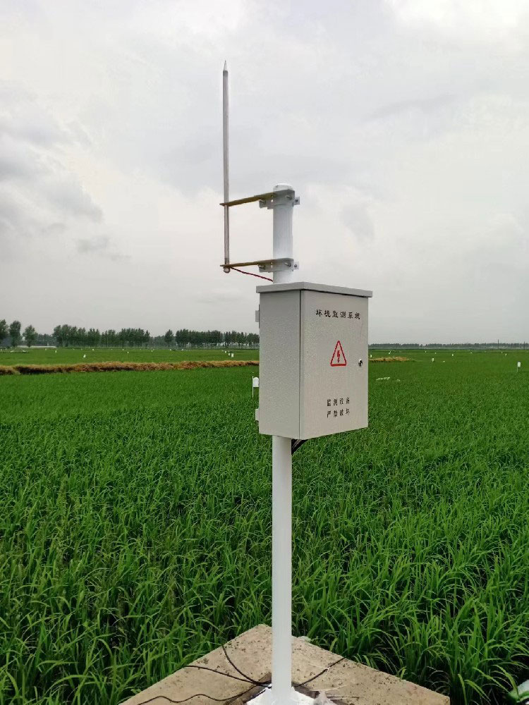
A practical station should include an IP65 outdoor host, real-time display, configurable acquisition interval, large storage capacity, and stable sensor input. The user should be able to view live values and curves, download historical records, export data, and generate reports for management review.
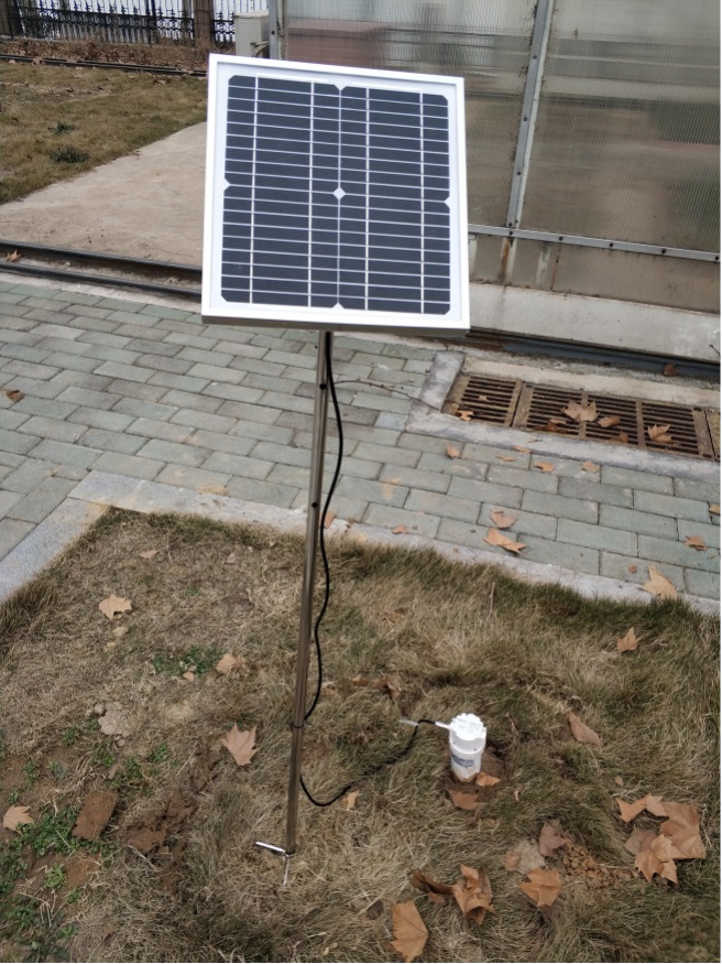
Flexible communication is another major performance requirement. Wired connection can be used where the monitoring center is close, while GSM, GPRS, 4G, 5G, or WiFi can support remote projects. Power can be designed with mains supply, solar panel, battery backup, or a combined method depending on site conditions.
| Performance Area | Recommended Configuration | Project Benefit |
|---|---|---|
| Outdoor protection | IP65 host and weatherproof cabinet | Supports long-term field operation in rain and dust |
| Display and storage | Large LCD, real-time curves, local records | Allows field checks and acceptance testing |
| Communication | Wired, GSM, GPRS, 4G, 5G, or WiFi options | Supports local and remote monitoring scenarios |
| Power supply | Mains, solar, battery, or combined backup | Keeps the station working during power fluctuation |
| Sensor layout | Single-point or multi-depth profile monitoring | Shows vertical soil water distribution |
| Platform output | Excel export, curves, reports, historical query | Supports irrigation review and management decisions |
A single surface sensor can miss important root-zone changes. In many irrigation projects, sensors are installed at several depths to show how water moves through the soil profile. This vertical layout helps the owner understand whether irrigation reaches the active root layer or whether water is lost below the target depth.
For integrators, each sensor depth should be named clearly in the platform. Labels such as 10 cm, 20 cm, 40 cm, or 60 cm are more useful than generic channel numbers. The data becomes easier to compare, report, and explain during project acceptance.
The station can collect real-time soil data and transmit it through wireless networks to a monitoring center or database. In a distributed farm, one gateway can serve several sensors if the layout and cable distances are planned correctly. For remote city-to-city management, 4G or WiFi upload allows managers to check sites without traveling.
A good platform should include device status, communication status, battery information, sensor values, curves, and exportable history. Alarm settings can be added for low moisture, excessive moisture, communication interruption, and power abnormality.
Soil moisture stations can be expanded with soil temperature, electrical conductivity, pH, groundwater level, and water quality sensors when the project requires more environmental context. This is useful in saline soil, greenhouse irrigation, fertigation, research farms, and water-saving agriculture demonstrations.
However, more parameters should be added for a reason. Procurement teams should avoid selecting sensors only because they are available. Each parameter should connect to a management decision, reporting requirement, or research objective.
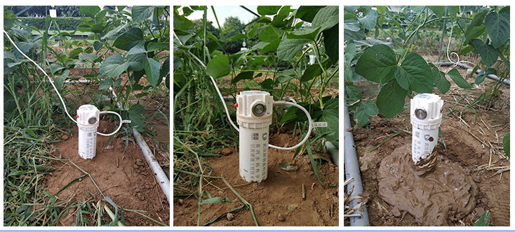
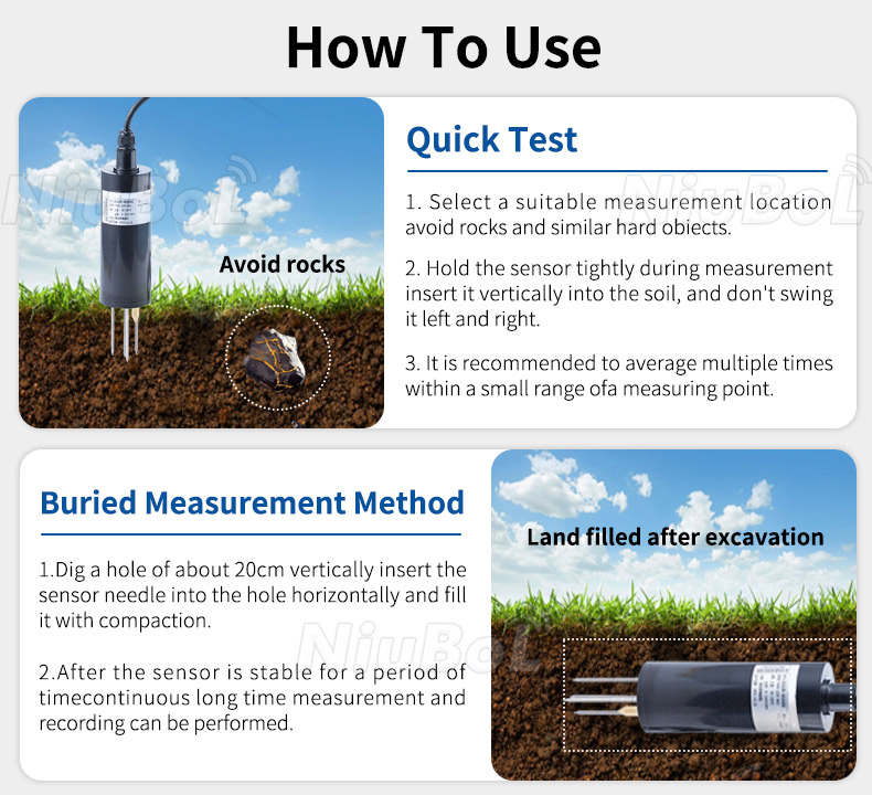
Sensor installation quality directly affects data reliability. Probes should contact soil fully, cables should be protected, and installation depth should match crop root distribution. Avoid air gaps, stones, loose backfill, or locations near irrigation emitters unless the monitoring objective specifically requires those points.
Maintenance should include checking the host enclosure, solar panel, battery, cable routes, sensor stability, and platform communication. The system should be easy to inspect because remote agricultural projects often have limited maintenance visits.
Before ordering, confirm the number of monitoring points, sensor depths, communication mode, power plan, data interval, platform functions, and report format. A drought management project may need different thresholds from a precision irrigation project, and a research farm may need more detailed export capability.
The best procurement package includes hardware, mounting accessories, wiring guidance, communication documents, platform configuration, and commissioning support. This helps contractors deliver a complete monitoring solution instead of a collection of separate devices.

Soil moisture values should be converted into practical irrigation rules with upper and lower thresholds, delay time, crop stage notes, and manual override options. A single fixed threshold may not fit every soil type or crop stage. The owner should review data after several irrigation cycles and adjust rules based on real field response.
When the platform stores irrigation events together with soil moisture curves, managers can see whether applied water reaches the target depth. This helps reduce unnecessary irrigation, identify blocked lines, and improve water-use planning across different plots.
During commissioning, technicians should compare sensor readings with field observations and installation records. The purpose is not to replace laboratory calibration, but to confirm that probes are installed correctly, labels match the physical depth, and values change reasonably after irrigation or rainfall.
A useful acceptance record includes sensor depth, soil condition, cable route, host status, communication signal, power source, platform screenshot, and export test. These records become important when the owner later adds more points or investigates abnormal data.
For a large farm, it may be better to purchase several moderate monitoring points than one highly complex station. Soil moisture varies by soil texture, slope, irrigation zone, crop type, and management practice. A distributed layout often produces more actionable information than a single point with many extra parameters.
Procurement teams should therefore ask how many decisions the system must support. If the owner manages ten irrigation zones, the sensor layout should reflect those zones. Hardware quantity should follow management logic, not only budget convenience.
Soil moisture becomes more meaningful when it is reviewed together with rainfall, temperature, humidity, wind, and radiation. A hot, windy period may increase water demand even when the soil was recently irrigated. A rain event may look significant but may not reach deeper sensors.
For integrators, this means soil stations and weather stations should not be treated as separate projects when the owner wants irrigation decisions. A combined dashboard gives a clearer explanation of field water movement.
Abnormal readings should trigger a clear service process. The team should check whether the value is caused by real field change, sensor installation movement, cable damage, communication delay, or power interruption. Without this process, the owner may lose confidence in the data.
The platform should mark missing data, low battery, and communication faults separately from true soil moisture alarms. This distinction helps operators respond correctly and reduces unnecessary irrigation changes.
Farm managers should understand how to read curves, compare depths, export data, and interpret alarms. Training does not need to be complicated, but it should connect platform values to daily irrigation decisions.
When the user understands the purpose of each sensor and depth label, the station is more likely to be used continuously. This increases the practical return of the monitoring investment.
Depth labels are not a small detail. A curve marked only as channel one or channel two is difficult for managers to use. A curve marked as 20 cm or 40 cm immediately tells the user which root-zone layer is changing.
This clarity is especially important when different crops, soil types, or irrigation methods are compared in one platform. Good labels reduce training time and reduce mistakes during operation, especially when several farms are managed through the same account and reviewed by different operators.
Its main purpose is to provide continuous soil water data for irrigation timing, drought prevention, crop production planning, and field water balance analysis. The station helps managers understand soil conditions in real time and compare historical trends across seasons or irrigation events.
Multi-depth monitoring shows how water is distributed through the soil profile. Surface moisture may change quickly after rain or irrigation, while deeper layers show whether water reaches the root zone. This helps prevent under-irrigation, over-irrigation, and water loss below the active crop layer.
Yes. A soil moisture station can use solar power and battery backup where mains power is unavailable. The power plan should be matched to the communication method, data interval, sensor quantity, local sunlight conditions, and required autonomy during cloudy weather.
4G is commonly selected for remote farmland because it supports long-distance data upload without cable infrastructure. Wired communication can be used for short distances or centralized fields. The final choice should consider signal quality, power consumption, maintenance access, and platform requirements.
Yes. Soil temperature, electrical conductivity, pH, groundwater level, and water quality sensors can be added when the project needs more information. These parameters are useful for fertigation, saline soil management, greenhouse production, research farms, and water resource monitoring.
Sensors should be installed at representative points and depths that match crop root distribution and irrigation zones. They should not be placed only where installation is easy. Each point should be labeled by field name, crop type, depth, and irrigation zone so the platform data can be interpreted correctly.
Useful functions include live data, historical curves, Excel export, reports, alarm records, device status, and multi-site grouping. For project delivery, these functions help the owner use the data for management rather than only viewing current values.
NiuBoL supports configurable soil monitoring, multiple communication options, flexible power supply, long-term field operation, and platform-oriented data output. This makes it suitable for irrigation projects, drought management, agricultural research, and remote soil condition monitoring.
A soil moisture monitoring station becomes valuable when it is designed around irrigation decisions, field layout, and long-term data use. Multi-depth sensing, reliable communication, flexible power, clear platform labels, and practical maintenance all determine project success. NiuBoL soil monitoring solutions provide a configurable foundation for irrigation management, drought response, and agricultural data systems.
Related recommendations
Sensors & Weather Stations Catalog
 Agriculture Sensors and Weather Stations Catalog-NiuBoL.pdf
Weather Stations Catalog-NiuBoL.pdf
Agriculture Sensors Catalog-NiuBoL.pdf
Water Quality Sensor Catalog-NiuBoL.pdf
Related products
 Combined air temperature and relative humidity sensor
 Soil Moisture Temperature sensor for irrigation|NBL-S-THR
 Soil pH sensor RS485 soil Testing instrument soil ph meter for agriculture |NBL-S-PH
 Wind Speed sensor Output Modbus/RS485/Analog/0-5V/4-20mA
 Tipping bucket rain gauge for weather monitoring auto rainfall sensor RS485/Outdoor/stainless steel
 Pyranometer Solar Radiation Sensor 4-20mA/RS485

Screenshot, WhatsApp to identify the QR code
WhatsApp number:+8615367865107
(Click on WhatsApp to copy and add friends)
