


— Blogs —
—Products—
 Consumer hotline +8618073152920
 WhatsApp:+8615367865107
Address:Room 102, District D, Houhu Industrial Park, Yuelu District, Changsha City, Hunan Province, China
Product knowledge
Time:2025-12-13 13:54:04 Popularity:697
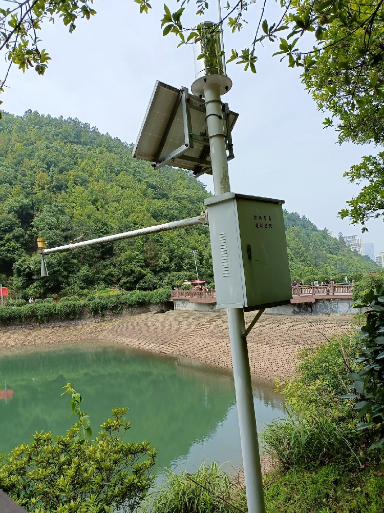
Radar water level gauge, also commonly known as water level radar, is an electronic device that uses high-frequency electromagnetic waves to detect target distance and liquid level height. Compared with traditional contact measurement (e.g., float type) or differential pressure measurement, radar water level gauge occupies an irreplaceable position in water conservancy monitoring with its unique non-contact measurement method.

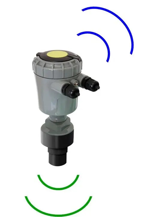
Radar water level gauge emits electromagnetic waves (microwave pulses) toward the water surface, receives the signal reflected back from the water surface, and calculates the distance from the sensor to the water surface using the propagation time of electromagnetic waves, thereby indirectly obtaining the actual water level.
The non-contact characteristic of radar water level gauge makes it exhibit excellent performance and stability in complex outdoor water environments:
Strong environmental interference resistance: Unaffected by atmospheric temperature, pressure, air density, wind, rainfall, or relative humidity.
High water quality tolerance: Unaffected by pollutants, sediments, floating debris (e.g., aquatic plants, garbage) in water, no need for wave protection well.
High precision & large measurement range: Measurement accuracy can reach millimeter (mm) level, wide measurement range, e.g., up to 30 meters, even high-end products like NiuBoL up to 65 meters, meeting large reservoir and river monitoring needs.
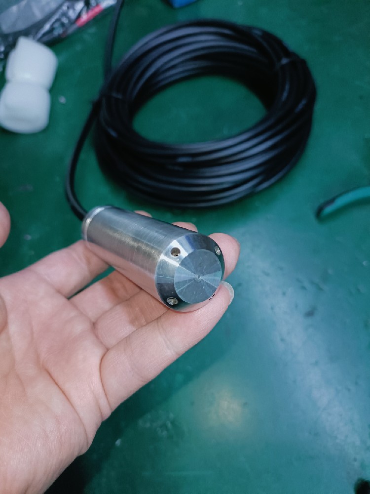
Low maintenance & long lifespan: Non-contact measurement means probe does not contact water body, low wear, extremely low maintenance cost, long service life.
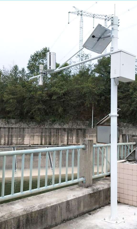
Easy integration: Continuous acquisition possible, with solar power system added, very convenient for unattended management and remote real-time monitoring.
The core technology of radar water level gauge lies in how it precisely measures the “round-trip” time of electromagnetic waves to the water surface and converts tiny nanosecond-level time differences into accurate distance data.
Radar pulse emitted from antenna, reflected back from water surface, received by the same antenna.
Distance (D) = Electromagnetic wave propagation speed (C) * Round-trip time (T)/2
Since electromagnetic wave propagation speed C is constant (speed of light), measuring precise round-trip time T yields distance D to water surface.
Modern radar water level gauges like NiuBoL mostly adopt Frequency Modulated Continuous Wave (FMCW) technology, especially operating in 77GHz~79GHz high-frequency millimeter wave radar.
Working Steps:
Emission signal: Antenna emits extremely narrow microwave pulses with frequency linearly changing over time (frequency modulation).
Reception signal: Receives pulse signal reflected from water surface.
Time difference calculation: Due to tiny time interval between emission and reception, mix current emitted signal with received signal at receiver end to produce difference frequency signal.
Distance conversion: This difference frequency signal fb is proportional to radar distance D. By measuring millisecond-level fb, nanosecond-level time T can be calculated with high precision, thereby obtaining distance D.
FMCW Advantages: Compared with traditional pulse radar, FMCW radar has larger operating bandwidth, resulting in higher measurement resolution and accuracy, while achieving more compact RF architecture and smaller measurement blind zone.
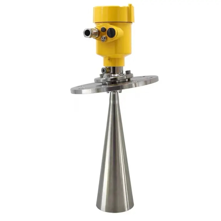
NiuBoL radar level gauge utilizes 77GHz~79GHz frequency modulated continuous wave technology to achieve high-performance water level monitoring.
High-frequency broadband: Based on self-developed CMOS millimeter wave RF chip, high operating frequency, large bandwidth, ensuring millimeter-level measurement accuracy.
Small beam angle: Narrowest only 8° antenna beam angle, concentrated energy, strong anti-interference. Less affected by environmental interferers (e.g., river banks, pipes) during installation.
Range & blind zone: Maximum range up to 65 meters, blind zone within 15 cm, strong applicability for large reservoirs.
Safety: Extremely low emission power, no harm to human body and environment.
Intelligent: False echo filtering function, improving measurement reliability.
Integrated design: Integrated lens design, compact size, easy rapid installation.

| Technical Parameter | Specification | Remarks |
| Emission Frequency | 77GHz~79GHz | High-frequency millimeter wave for high precision |
| Measurement Range | 0.15 m ~ 65 m | Meets most water conservancy monitoring needs |
| Resolution | 1 mm | Extremely high data detail capture capability |
| Measurement Accuracy | ±1 mm | Typical accuracy under standard conditions (4 m, 40% RH, 25°C) |
| Beam Angle | 8° | Concentrated energy, strong anti-interference |
| Power Supply | DC 10–30 V | Wide voltage input |
| Maximum Power Consumption | 0.6 W | Extremely low power consumption, suitable for solar power |
| Communication Protocol | RS485 output | Industrial standard protocol, easy integration |
| Protection Level | IP67 | High-level dustproof and waterproof |

Radar water level gauge plays key role in multiple fields due to high precision and strong environmental adaptability:
Urban Waterlogging Monitoring & Warning: One of the most widespread applications. Real-time monitoring of water level changes in bridge culverts, low-lying roads, drainage pipes, urban rivers and lakes, providing real dynamic data for urban management backend, timely issuing waterlogging warnings, ensuring citizen life and property safety.
Hydrological Survey & Flood Control: Used for water level and storage monitoring in rivers, lakes, reservoirs, providing decision basis for water resource scheduling, flood control, and drought resistance.
Agricultural Irrigation: Monitors canal and irrigation area water level, achieving precise water resource allocation and efficient utilization.
Industrial Field: Applied in liquid level/water level monitoring in petroleum, chemical, power plants, urban drainage, and other industrial environments.

Radar water level gauge installation is relatively simple, but to ensure measurement accuracy, strictly note the following two points:
Verticality Guarantee:
Ensure water level gauge installed perpendicular to water surface. If tilted, reflected signal amplitude weakens, affecting normal ranging and accuracy.
Interference Avoidance:
Avoid emission beam hitting interferers such as river bank edges, pipes, brackets, installation bolts, etc., which may produce false echoes interfering with real water surface signal.
Narrower beam angle (e.g., NiuBoL 8°) makes it easier to avoid interferers during installation.
Recommend installation above open water surface; if must install in wave protection well, ensure well inner wall smooth and away from beam angle.

Q: Can radar water level gauge really achieve millimeter-level measurement accuracy?
A: Yes. Thanks to high-frequency millimeter wave (77GHz~79GHz) and FMCW technology high resolution, modern radar water level gauge can achieve ±1 mm accuracy in short distance and standard environment.
Q: Is radar water level gauge measurement affected by heavy rain or heavy fog?
A: Compared with ultrasonic, radar wave is minimally affected by atmospheric environment (e.g., rainfall, fog). Radar signal has strong penetration, maintaining stable measurement accuracy.
Q: Do floating debris on water surface (e.g., aquatic plants, plastic bottles) affect radar measurement?
A: Radar beam usually covers large water surface area, receiving average of large number of reflected signals. Single or few floating objects do not significantly affect overall measurement, and its non-contact measurement inherently unaffected by floating debris.
Q: What is the maximum range of NiuBoL radar water level gauge? Suitable for reservoir use?
A: NiuBoL radar level gauge maximum range up to 65 meters, fully meeting large river, reservoir, deep well, or water conservancy hub large range application needs.
Q: Why does radar water level gauge need extremely narrow beam angle?
A: Narrow beam angle (e.g., 8°) concentrates energy, improving signal-to-noise ratio; more importantly, maximally reduces emission beam hitting installation environment interferers (e.g., bridge structure, river bank, pipe wall), avoiding false echoes.
Q: How to ensure verticality during radar water level gauge installation?
A: Use level or professional installation bracket for adjustment. After installation, best view echo curve through system backend to ensure stable signal quality.
Q: Does radar water level gauge require regular calibration? High maintenance frequency?
A: Radar water level gauge is non-contact measurement, usually no frequent calibration needed. No moving parts, very low maintenance cost, only regular check surface for dirt or condensation, confirm installation stability.
Q: How is radar water level gauge power consumption? Can use solar power?
A: Modern radar water level gauge (e.g., NiuBoL, maximum power consumption 0.6 W) focuses on low power consumption, very suitable for solar power system and battery use, achieving long-term reliable outdoor unattended monitoring.
Q: Does radar water level gauge have radiation harm to human body?
A: NiuBoL radar level gauge emission power extremely low, complies with relevant safety standards, no harm to human body and environment, safe to use.
Q: What is blind zone in radar water level gauge? How to avoid blind zone affecting measurement?
A: Blind zone refers to minimum distance near sensor antenna where accurate measurement impossible. NiuBoL product blind zone within 15 cm, meaning water surface cannot be closer than 15 cm to sensor. Installation should consider height difference between highest water level and installation position, ensuring highest water level does not enter blind zone.
Q11: What certifications does NiuBoL have?
A11: CE, ISO9001, RoHS, and nationally recognized meteorological calibration certificates.
Radar water level gauge, with high precision, high reliability, and unique advantages of non-contact measurement, is becoming the main technical means for water conservancy monitoring and urban waterlogging warning systems. Especially high-frequency FMCW technology-based NiuBoL radar level gauge, with millimeter-level accuracy, ultra-low power consumption, and small beam angle features, provides stable and efficient solutions from agricultural irrigation to large reservoir monitoring. Farewell to many limitations of traditional measurement methods, radar water level gauge is safeguarding our water conservancy safety with the power of technology.
Next Step: Do you need a detailed NiuBoL radar level gauge product brochure and quotation, or a customized installation point layout suggestion for your specific application scenario (e.g., urban waterlogging monitoring)?
Prev:Dissolved Oxygen Sensor (DO): Principle, Faults & NiuBoL Fluorescence Method Application Guide
Next:Comparative Analysis of Different Types of Solar Radiation Sensors
Related recommendations
Sensors & Weather Stations Catalog
 Agriculture Sensors and Weather Stations Catalog-NiuBoL.pdf
Weather Stations Catalog-NiuBoL.pdf
Agriculture Sensors Catalog-NiuBoL.pdf
Water Quality Sensor Catalog-NiuBoL.pdf
Related products
 Combined air temperature and relative humidity sensor
 Soil Moisture Temperature sensor for irrigation|NBL-S-THR
 Soil pH sensor RS485 soil Testing instrument soil ph meter for agriculture |NBL-S-PH
 Wind Speed sensor Output Modbus/RS485/Analog/0-5V/4-20mA
 Tipping bucket rain gauge for weather monitoring auto rainfall sensor RS485/Outdoor/stainless steel
 Pyranometer Solar Radiation Sensor 4-20mA/RS485

Screenshot, WhatsApp to identify the QR code
WhatsApp number:+8615367865107
(Click on WhatsApp to copy and add friends)
