


— Blogs —
—Products—
 Consumer hotline +8618073152920
 WhatsApp:+8615367865107
Address:Room 102, District D, Houhu Industrial Park, Yuelu District, Changsha City, Hunan Province, China
Product knowledge
Time:2026-04-08 10:54:49 Popularity:406
With the acceleration of global urbanization, urban underlying surface conditions have undergone fundamental changes. The increase in impervious area has changed the natural rainfall-runoff relationship, and traditional confluence models are no longer able to accurately describe the mechanism of urban waterlogging. In order to cope with sudden heavy rainfall and improve water environment purification efficiency, water conservancy engineering integrators and municipal departments have put forward stringent requirements for the real-time, accuracy and stability of hydrological monitoring.
NiuBoL, as a professional environmental perception hardware manufacturer, is committed to developing fully automatic monitoring systems based on microwave radar technology. Through non-contact measurement methods, we solve the pain points of traditional contact sensors that are easily affected by sediment deposition, floating object impact and sewage corrosion, and provide a reliable data base for urban flood warning and water resource scheduling.

The change of urbanization to the underlying surface of the basin is mainly reflected in two dimensions: first, the decline of surface permeability capacity, leading to earlier runoff peak and increased flow; second, the flow velocity distribution of river sections becomes complex. Traditional theories and monitoring equipment often face huge workload and high economic cost when dealing with test river sections affected by engineering (such as reservoir regulation, gate and dam opening and closing).
Therefore, implementing online flow monitoring has become an inevitable choice for modern smart water affairs. Using shore-based non-contact radar wave technology, all-weather, unattended real-time monitoring can be achieved, ensuring continuous and accurate water level and flow velocity data even under harsh weather and complex working conditions.
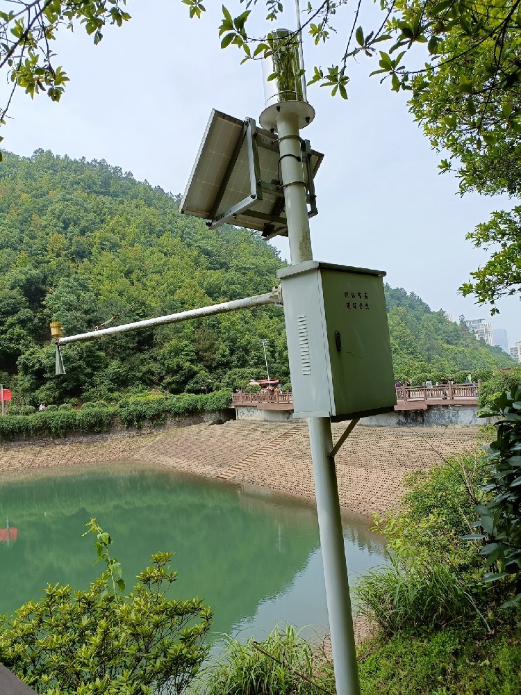
To meet different monitoring needs, NiuBoL has launched two industrial-grade core sensors: high-precision radar water level gauge and integrated radar flow meter.
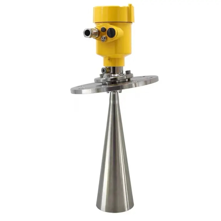
This product is based on self-developed CMOS millimeter-wave RF chip, operates in the 77GHz~79GHz frequency band, and adopts frequency-modulated continuous wave (FMCW) principle. Compared with traditional 24GHz radar, it has higher signal-to-noise ratio, smaller blind zone and narrower beam angle.

| Parameter Item | Technical Index | Remark |
|---|---|---|
| Supply Voltage | DC 10V - 30V | Wide voltage input, adapts to various power supply environments |
| Maximum Power Consumption | ≤ 0.6W | Extremely low power consumption, suitable for solar power supply system |
| Transmit Frequency | 77GHz ~ 79GHz | FMCW frequency-modulated continuous wave technology |
| Measurement Range | 0.15 m ~ 65m | Supports deep well and large-span bridge installation |
| Resolution | 1mm | Millimeter-level sensing accuracy |
| Measurement Accuracy | ±1mm | @4m standard environment |
| Beam Angle | 8° | Narrow beam, strong anti-interference ability |
| Protection Level | IP67 | Industrial-grade waterproof and dustproof design |
| Communication Protocol | RS485 (Modbus-RTU) | Standard bus, easy for system integration |

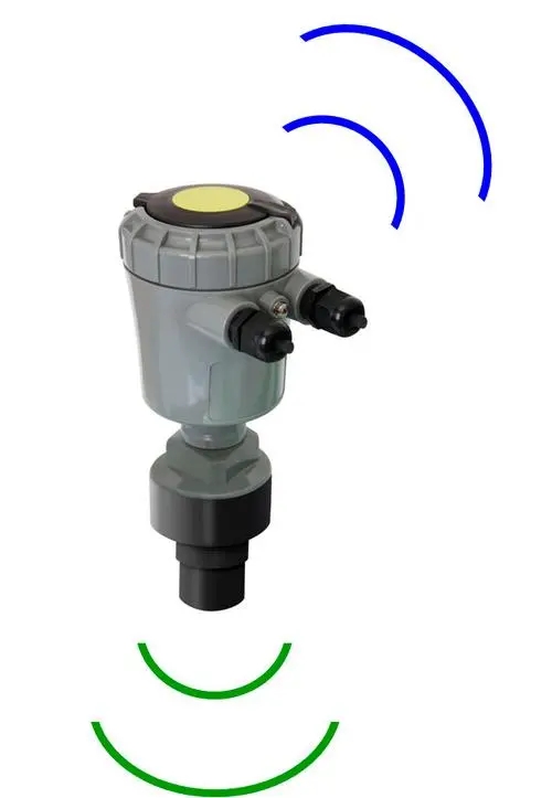
This integrated sensor combines 24GHz K-band planar radar velocity measurement technology and 77GHz millimeter-wave radar ranging technology. It can not only measure water level but also obtain water surface flow velocity in a non-contact manner, and output real-time cross-section flow combined with built-in algorithms.
| Function Item | Parameter Index | Remark |
|---|---|---|
| Velocity Measurement Transmit Frequency | 24.00GHz | K-band radar velocity measurement |
| Velocity Measurement Range | 0.1 ~ 20m/s | Supports high flow velocity flood discharge monitoring |
| Velocity Measurement Accuracy | ±2% | Velocity resolution 0.01m/s |
| Water Level Ranging Frequency | 76GHz ~ 81GHz | Wideband water level sensing |
| Water Level Range | 0.1 ~ 65m | Independent water level measurement mode |
| Installation Height | 0 ~ 20m | Recommended to use within this height range |
| Operating Power Consumption | ≤ 1.3W | Meets low power consumption requirements of field automatic stations |
| Beam Angle | Water level 6°×6° / Velocity 30°×80° | Optimized irradiation area |
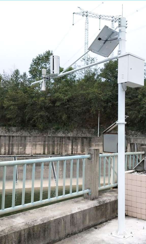
NiuBoL hydrological monitoring system is widely used in urban infrastructure construction and natural water body management:
River and irrigation canal monitoring: In multi-sand and easily silted river sections, non-contact measurement avoids sensor failure caused by sediment coverage or water weed entanglement.
Underground drainage pipe network: Compact size and IP67 protection level enable installation in humid and corrosive sewers to monitor waterlogging risks in real time.
Flood warning system: Extremely short response time and high-frequency sampling provide first-hand warning data for mountain flood outbreaks or dam discharge.
Smart water operation and maintenance: Assist urban water supply and sewage monitoring, realize remote digital management through RS485 bus, and reduce manual inspection costs.
To ensure the stability and accuracy of the monitoring system during long-term operation, engineering installation must follow the following professional guidelines:
Elevation safety: Installation position must be higher than the local flood control standard maximum water level to prevent equipment from being directly washed away by extraordinary floods.
Verticality calibration: The horn mouth must be installed perpendicular to the water surface. If tilted, the echo signal strength will attenuate, directly causing deviation in measurement distance.
Beam obstacle avoidance: No obstructions are allowed between the horn mouth and the water surface. When installed on the shore, the horizontal distance between the center position and the shore wall must be greater than the irradiation radius of the radar beam at the current height.
Water flow stability: The test channel section should be as straight and stable as possible, avoiding installation in areas with huge boulders, vortices or turbulent flow.
Section regularization: It is recommended to harden the test channel section. A regular section helps improve the accuracy of the correction coefficient of the flow calculation formula.
Installation orientation: The inclined surface side of the radar flow meter should be installed parallel to the water flow direction. It is usually recommended to install at the head, middle or center of the river.

In project delivery, 80% of measurement errors originate from the physical installation environment. NiuBoL has summarized the following engineering avoidance points:
1. Avoid “multipath reflection” interference
When installing in underground drainage pipe networks or narrow vertical channel sections, radar waves may produce multiple reflections on well walls or channel banks.
NiuBoL optimization: Our 77GHz water level gauge has an 8° narrow beam. During installation, ensure that the horizontal distance L between the central axis and the wall surface is greater than H*tan(4°) (H is the installation height) to avoid “false echoes” causing water level lock.
2. Eliminate “flow turbulence” influence
Radar flow meter monitors the Doppler frequency shift of small water surface ripples.
Site selection suggestion: Monitoring points should be selected in straight sections, avoiding waterfall areas or stilling basins downstream of gates. If the water surface is too calm (such as mirror water), the system supports optional “spoiler plate” to artificially create microwaves to activate radar echo sensing.
1. What are the advantages of the 77GHz frequency of NiuBoL radar water level gauge compared to 24GHz?
A: 77GHz has wider bandwidth and can provide higher distance resolution. At the same time, the 8° narrow beam angle means more concentrated energy, less affected by lateral interference such as river bank brackets and vegetation swing, and stronger installation environment adaptability.
2. How does non-contact measurement handle water surface fluctuations?
A: The sensor has built-in advanced digital filtering algorithms that can smooth the original sampling data multiple times per second. Even in windy and wavy conditions, it can output the average value representing still water level.
3. How is the “correction coefficient” in the radar flow meter determined?
A: The correction coefficient is determined based on the proportional relationship between the surface flow velocity measured by the sensor and the average cross-section flow velocity. NiuBoL algorithm has built-in preset values for multiple channel models, and engineers can also fine-tune in the background according to the comparison results of actual flow velocity meters.

4. How does the system perform in extreme weather (such as heavy rain and heavy snow)?
A: The measurement process is based on microwave technology and is not subject to physical limitations of air temperature, pressure, precipitation or relative humidity. The sealed IP67 design ensures stable signal output even in heavy rain environments.
5. What is the maximum communication distance of the sensor?
A: RS485 bus can transmit 1200 meters in standard environment. With NiuBoL signal gain technology, the farthest communication distance can reach 2000 meters. For longer requirements, we recommend integrating 4G/GPRS communication host.
6. Does the equipment power consumption support full solar power supply?
A: Fully supported. The maximum power consumption of NiuBoL water level gauge is only 0.6W, and the flow meter is 1.3W. In field automatic station applications, it can achieve long-term uninterrupted operation with a 60W solar panel and battery.
7. What is the impact of blind zone size on installation?
A: Our product blind zone is within 15cm. During installation, ensure that the clearance height from the sensor to the highest possible water level is greater than this value to prevent entering the measurement dead zone.
8. How to ensure the physical safety of the radar sensor?
A: On steeper or easily impacted shores, it is recommended to use NiuBoL customized pole support components and equip lightning protection boxes. The support pole design should consider wind and earthquake resistance to ensure that the horn mouth does not shift under extreme weather.
In today’s highly developed urbanization, efficient, low-consumption and precise hydrological monitoring is the lifeline to ensure the safe operation of cities. NiuBoL radar water level gauge and flow monitoring system provide maintenance-free and easy-to-integrate solutions for integrators and engineering contractors through non-contact K-band and millimeter-wave technology.
We not only provide high-quality hardware equipment but also provide full-chain support from scheme selection, installation guidance to data analysis. Choosing NiuBoL means choosing a long-term technical partner that can cope with harsh working conditions and enhance project delivery competitiveness.
Copyright © NiuBoL. If you need detailed technical manuals, CAD installation drawings and bulk procurement quotations, please contact the NiuBoL global sales team.
Related recommendations
Sensors & Weather Stations Catalog
 Agriculture Sensors and Weather Stations Catalog-NiuBoL.pdf
Weather Stations Catalog-NiuBoL.pdf
Agriculture Sensors Catalog-NiuBoL.pdf
Water Quality Sensor Catalog-NiuBoL.pdf
Related products
 Combined air temperature and relative humidity sensor
 Soil Moisture Temperature sensor for irrigation|NBL-S-THR
 Soil pH sensor RS485 soil Testing instrument soil ph meter for agriculture |NBL-S-PH
 Wind Speed sensor Output Modbus/RS485/Analog/0-5V/4-20mA
 Tipping bucket rain gauge for weather monitoring auto rainfall sensor RS485/Outdoor/stainless steel
 Pyranometer Solar Radiation Sensor 4-20mA/RS485

Screenshot, WhatsApp to identify the QR code
WhatsApp number:+8615367865107
(Click on WhatsApp to copy and add friends)
