


— Blogs —
—Products—
 Consumer hotline +8618073152920
 WhatsApp:+8615367865107
Address:Room 102, District D, Houhu Industrial Park, Yuelu District, Changsha City, Hunan Province, China
Product knowledge
Time:2026-02-01 10:12:09 Popularity:515
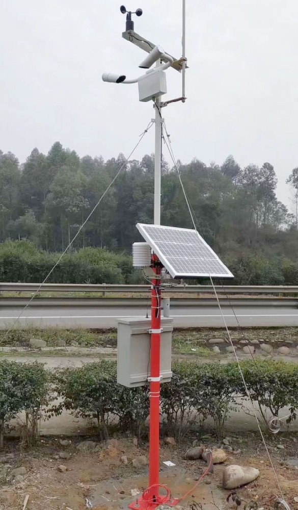
In modern expressway and national/provincial trunk road traffic management systems, meteorological conditions have become one of the most important non-structural factors affecting traffic safety and network efficiency. When designing traffic meteorological monitoring systems, system integrators need a reliable sensing platform capable of all-weather, continuous collection of multi-dimensional meteorological and road surface condition data. NiuBoL road weather monitoring station (including expressway integrated weather monitor series) integrates high-precision multi-element sensors, edge computing, and industrial-grade communication modules to provide real-time, high-resolution data support for traffic management departments, maintenance units, and emergency command centers, realizing the transition from passive response to predictive management.
From the perspective of system integrators, this system is not just a collection of sensors but a complete sensing node that can seamlessly access provincial traffic meteorological platforms, ETC gantry systems, and GIS decision support. Its data can directly drive business processes such as dynamic speed limits, vehicle-type restrictions, entrance closures, snow-melting agent spreading timing, and maintenance operation windows, significantly enhancing road network resilience under adverse weather conditions.
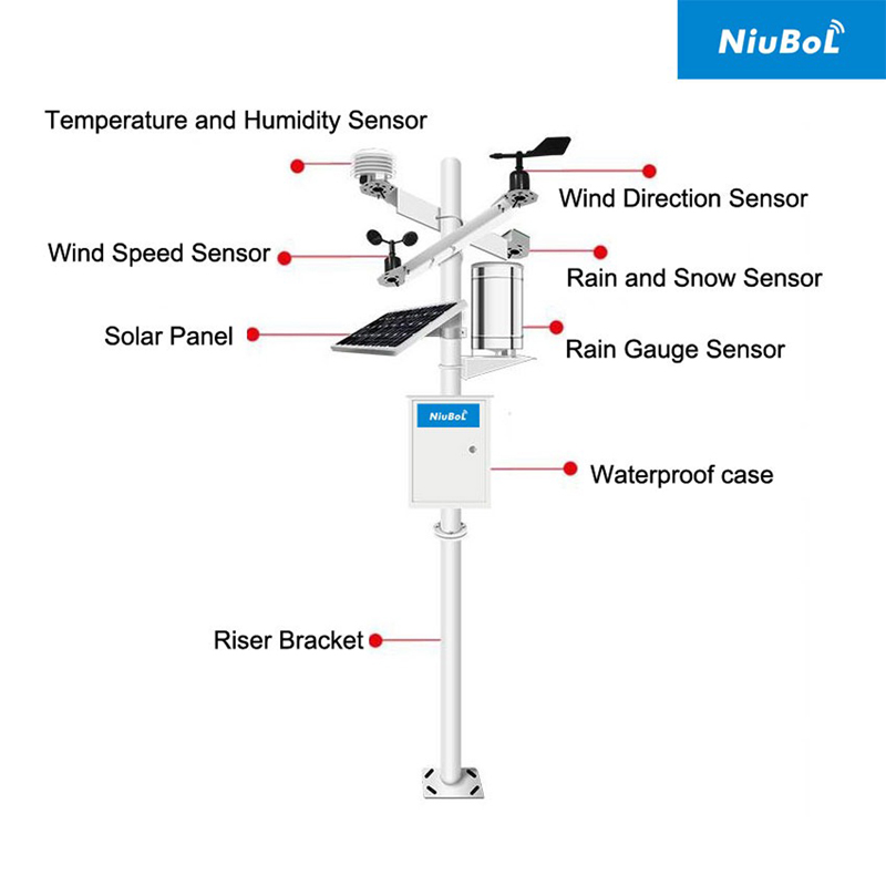
Modern road weather monitoring stations have evolved from single-element to multi-element integration. NiuBoL systems typically cover the following key parameters:
Conventional meteorological six elements: Air temperature (-40~+60℃, accuracy ±0.3℃), relative humidity (±3%RH), air pressure, wind speed (0~60 m/s, accuracy ±0.1 m/s or better), wind direction (±2°), precipitation amount (resolution 0.2 mm, intensity 0~4 mm/min, accuracy ±4%).
Visibility: Based on forward scattering principle, measurement range 5 m~10 km, error ±2%~10%, suitable for identifying various low-visibility processes such as团雾 (patchy fog), radiation fog, and precipitation fog.
Road surface condition: Infrared remote sensing road surface temperature (-40~+60℃), dry/wet/damp/ponding/icy state discrimination, ponding depth 0~10 mm, ice thickness 0~2 mm, slipperiness coefficient 0.01~0.82. Some configurations support AI vision-assisted identification of “black ice” risk.
The system architecture usually adopts a modular design:
Sensor layer → Edge acquisition and preprocessing unit → Communication layer (4G/5G main channel + Beidou/GPS short message backup) → Cloud/edge collaborative platform.
NiuBoL equipment features built-in industrial-grade edge computing, supporting local threshold alarms, data caching, and abnormal self-diagnosis to ensure data integrity during network interruptions.
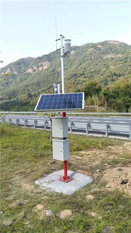
1. Expressway fog zones and high-incidence patchy fog road sections
In mountainous expressways, monitoring stations are densely deployed every 3~5 km. When visibility drops below 200 m, the system automatically links variable speed limit signs and information boards to issue instructions such as “Low visibility ahead, speed limit 40 km/h”. Integrators can access the data to provincial traffic meteorological platforms for cross-section linkage warnings.
2. Bridges, tunnel entrances, and high-fill icing road sections
Additional stations are set up specifically for icing-prone points. When road surface temperature approaches 0℃ and humidity >85%, icing warning is triggered, linking snow-melting agent spreading vehicles for precise operations. After deployment in a certain expressway project in Qinghai, winter icing-related accidents decreased by about 30%.
3. Wind gap areas and crosswind-affected road sections
When wind speed >20 m/s and duration exceeds the threshold, restrictions or persuasion to return are implemented for trucks and hazardous chemical vehicles. The system can associate with toll stations and gantry ETC data to achieve vehicle-type dynamic control.
4. Heavy rain and flash flood geological disaster-prone road sections
Combined with rainfall, road ponding depth, and historical rainfall threshold models, early warning of subgrade erosion and slope landslide risks is provided to support traffic control and emergency restoration decisions.
5. Maintenance decision support
Long-term accumulated road surface temperature, slipperiness coefficient, and precipitation data are used to optimize crack sealing, overlay, and drainage facility inspection cycles, avoiding ineffective operations under extreme weather and improving road service life.
When selecting, system integrators can refer to the following engineering principles:
1. Road section risk grading
- High risk (frequent patchy fog, icing, strong wind): Full-element station (including visibility + road surface condition), spacing 3~10 km.
- Medium risk (general mountainous/hilly): Six elements + visibility, spacing 10~15 km.
- Low risk (plain areas): Basic six-element station, spacing 15~20 km.
2. Sensor configuration priority
- Fog zones prioritize forward scattering visibility meter (10 km range).
- Winter icing sections must include road surface condition sensor (infrared + slipperiness coefficient).
- Strong wind areas prioritize ultrasonic wind speed & direction (no mechanical parts, resistant to icing and dust).
3. Communication and power supply reliability
Prioritize 4G/5G; solar + lithium iron phosphate battery pack to ensure 7~30 days of continuous cloudy/rainy operation.
4. Expansion and compatibility
Supports MODBUS RTU, MQTT, OPC UA and other protocols for easy access to existing traffic information platforms; reserved interfaces for AI vision, laser road surface detection, etc.
5. Protection and anti-damage
IP65 or above protection, self-toppling pole (resistant to level 12 wind), optional anti-theft fence + video surveillance.

1. Site selection and environmental representativeness
Station ≥30 m from main line, avoid heat islands (service areas, gas stations >100 m), strong light sources, electromagnetic interference sources; visibility meter receiving unit strictly faces north, axial deviation ≤0.1°.
2. Installation height and layout specifications
Wind speed & direction sensor 10 m above ground (or 3.5~10 m per specification); temperature & humidity in Stevenson screen at 1.5 m height; road surface condition sensor installed on shoulder or embedded; sensor spacing ≥2 m to avoid mutual obstruction.
3. Anti-interference and false alarm prevention
Rain gauge >1.5 m from guardrail to prevent splash; visibility meter with sunshade; road surface condition sensor regularly calibrates background radiation.
4. Power supply and communication design
Solar panel tilt adjusted according to local latitude + season; communication module supports main/backup switching, data cache ≥72 hours; add power surge protection and signal lightning protection.
5. Calibration and maintenance mechanism
Visibility meter quarterly scattering coefficient calibration; temperature & humidity annual error exceeding standard replacement; establish three-level maintenance: daily cleaning (2 weeks), quarterly accuracy verification, annual comprehensive verification.
6. Data access and threshold configuration
Define multi-level threshold alarms (warning/alert/control), support linkage with variable information boards and navigation platform APIs; edge preprocessing reduces cloud load.

Q1. What is the main difference between road weather monitoring stations and ordinary automatic weather stations?
Road weather stations emphasize traffic-specific elements such as visibility, road surface condition, and slipperiness coefficient; data directly serves traffic control and maintenance decisions, rather than general meteorological forecasting.
Q2. What are the differences in visibility sensor performance between patchy fog and precipitation fog?
Forward scattering principle is sensitive to aerosols, with higher identification accuracy for patchy fog (radiation fog); precipitation fog requires comprehensive judgment combined with rainfall intensity data.
Q3. How does the road surface condition sensor distinguish “black ice” from ordinary slipperiness?
Through infrared temperature and slipperiness coefficient combination, it can identify transparent thin ice risk when temperature is close to 0℃ and coefficient<0.2.
Q4. Is the wind speed sensor prone to damage in strong wind environments?
Recommend ultrasonic type without mechanical parts, combined with self-toppling pole, resistant to gusts above level 12.
Q5. Can solar power reliably operate during continuous rainy weather?
Using large-capacity lithium iron phosphate battery + high-efficiency MPPT controller, typical configuration supports 15~30 days of continuous cloudy/rainy conditions.
Q6. How does the monitoring station data interface with traffic platforms?
Supports MQTT, HTTP, WebService, and other protocols.
NiuBoL road weather monitoring station, with multi-element integrated sensing, industrial-grade reliable communication, and traffic-specific algorithms as its core, provides system integrators with practical, scalable traffic meteorological solutions. In road sections prone to multiple disasters such as fog, ice, wind, and rain, the system drives dynamic control and preventive maintenance through precise data, effectively reducing meteorology-related accident rates and road network interruption durations. It has been verified in multiple provincial expressway projects.
If you are a system integrator, IoT solution provider, or traffic engineering contractor planning new construction, expansion, or upgrade of expressway/national-provincial trunk road meteorological monitoring systems, welcome to contact the NiuBoL team for detailed technical solutions, typical configuration lists, project case references, or on-site testing support. We provide full-chain professional assistance from sensor selection to platform integration, jointly promoting the intelligent upgrade of traffic meteorological sensing systems.
Related recommendations
Sensors & Weather Stations Catalog
 Agriculture Sensors and Weather Stations Catalog-NiuBoL.pdf
Weather Stations Catalog-NiuBoL.pdf
Agriculture Sensors Catalog-NiuBoL.pdf
Water Quality Sensor Catalog-NiuBoL.pdf
Related products
 Combined air temperature and relative humidity sensor
 Soil Moisture Temperature sensor for irrigation|NBL-S-THR
 Soil pH sensor RS485 soil Testing instrument soil ph meter for agriculture |NBL-S-PH
 Wind Speed sensor Output Modbus/RS485/Analog/0-5V/4-20mA
 Tipping bucket rain gauge for weather monitoring auto rainfall sensor RS485/Outdoor/stainless steel
 Pyranometer Solar Radiation Sensor 4-20mA/RS485

Screenshot, WhatsApp to identify the QR code
WhatsApp number:+8615367865107
(Click on WhatsApp to copy and add friends)
