


— Blogs —
—Products—
 Consumer hotline +8618073152920
 WhatsApp:+8615367865107
Address:Room 102, District D, Houhu Industrial Park, Yuelu District, Changsha City, Hunan Province, China
Product knowledge
Time:2026-04-03 15:01:26 Popularity:511
In modern water conservancy IoT and smart city construction, the real-time nature, accuracy of data, and the system's survivability under harsh working conditions are core indicators for measuring project success. Traditional contact water level gauges or ultrasonic sensors often exhibit high failure rates and high maintenance costs when facing river silt, corrosive sewage, or high-speed water flow.
The online automatic radar water level and rainfall monitoring system launched by NiuBoL adopts advanced 77GHz millimeter-wave radar technology, achieving a leap from “contact measurement” to “non-contact perception.” The system is specially designed for system integrators (SI) and engineering contractors, aiming to provide a highly reliable digital foundation for rivers, lakes, open channel irrigation, and urban drainage pipe networks.

The working principle of the radar water level sensor is based on electromagnetic wave ranging technology. Radar pulses are emitted from the antenna, the water surface reflection echo is received, and the round-trip time T is recorded. Since the electromagnetic wave propagation speed C is constant, the distance to the water surface can be accurately calculated by the formula D = (C × T)/2. The system uses nanosecond-level time measurement and converts it to millisecond-level processing, performing 55 samplings per second, combined with digital filtering algorithms to effectively suppress the influence of water surface fluctuations and achieve measurement accuracy close to still water level.
Compared with traditional contact water level gauges, radar measurement is not affected by atmospheric temperature, pressure, air density, wind force, precipitation, or relative humidity, nor is it disturbed by pollutants, sediments, or floating objects in the water. The non-contact design avoids problems such as silt deposition, corrosion, and biological attachment, significantly reducing maintenance frequency, and is particularly suitable for unattended field environments.
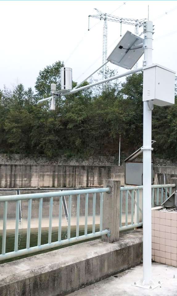
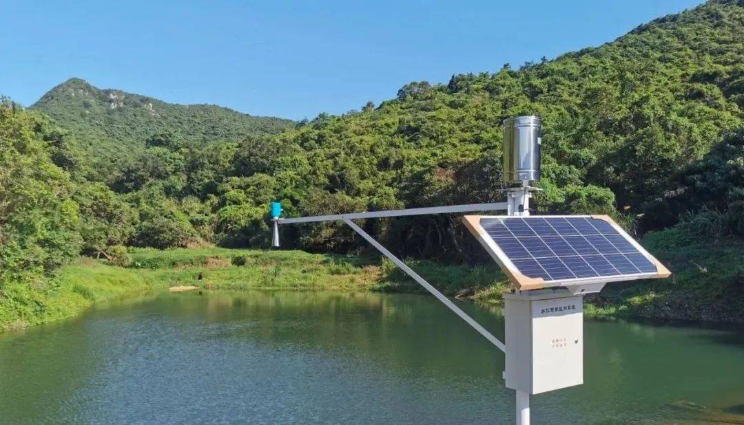
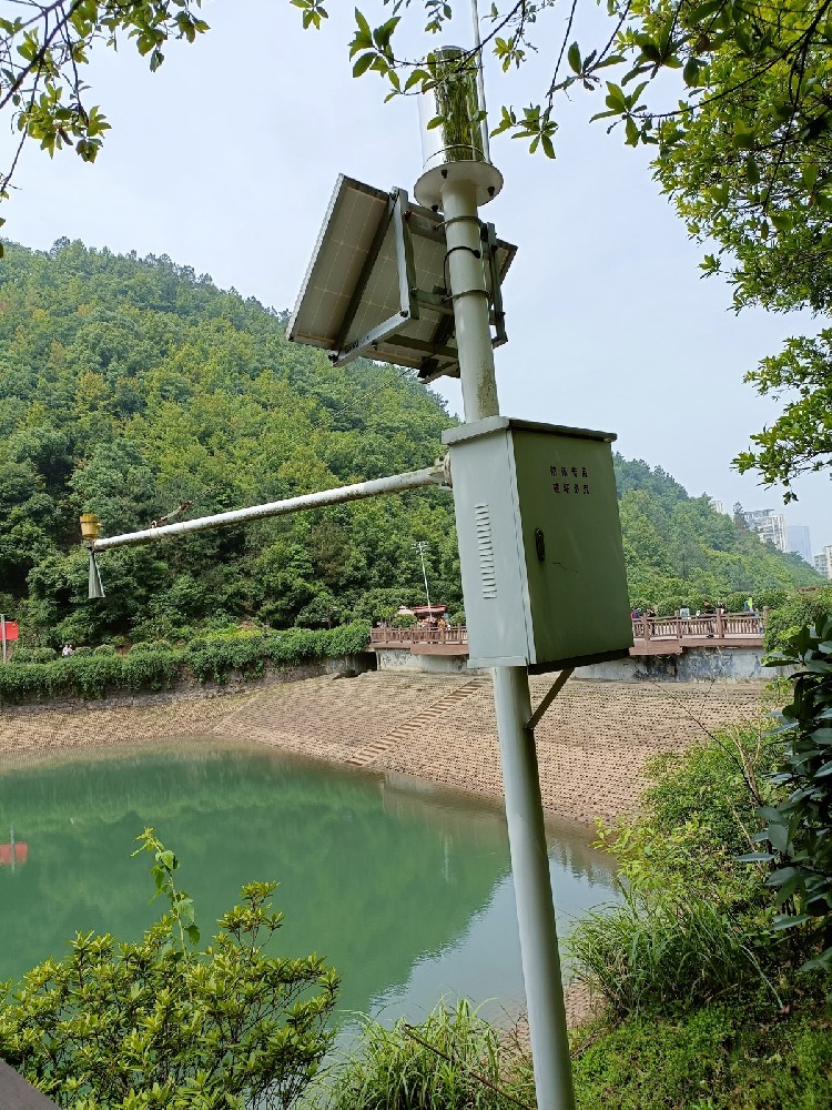
The NiuBoL online automatic radar water level and rainfall monitoring system adopts a horn antenna design, featuring low power consumption and wide voltage input characteristics, optimized for field automatic stations. The system supports flexible working mode configuration, with high measurement stability, and is suitable for lakes, rivers, reservoirs, open channels, wetlands, tidal water levels, and complex water areas containing a large amount of floating objects or aquatic weeds.
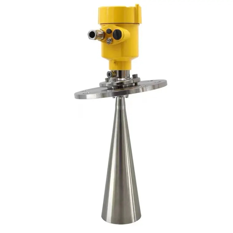
The NiuBoL radar water level gauge series products operate in the 77GHz~79GHz frequency band, using frequency modulated continuous wave (FMCW) technology, with a maximum range of up to 65m and a blind zone controlled within 15cm. The high-frequency band and large bandwidth design bring higher measurement resolution and accuracy. The product integrates a self-developed CMOS millimeter-wave RF chip to achieve a compact architecture and higher signal-to-noise ratio.
Main functional features include:
The narrowest 8° antenna beam angle effectively reduces the influence of interference objects in the installation environment and facilitates on-site deployment.
Integrated lens design, compact size, and easy installation.
Low power consumption design extends the endurance time of solar power supply systems.
Supports nut fixing method, integrated with water and rain condition poles and hosts.
| Parameter Item | Technical Index | Unit/Description |
|---|---|---|
| Power Supply Voltage | DC10-30V | Wide voltage input |
| Maximum Power Consumption | 0.6W | Low power consumption design |
| Transmit Frequency | 77GHz~79GHz | FMCW frequency modulated continuous wave |
| Measurement Range | 0.15m ~ 65m | Wide range applicable |
| Resolution | 1mm | High resolution |
| Measurement Accuracy | ±1mm (@4m, 40%RH, 25℃) | Millimeter-level accuracy |
| Beam Angle | 8° | Narrow beam, strong anti-interference |
| Operating Temperature Range | -40℃ ~ +80℃ | Adapt to harsh field environments |
| Protection Level | IP67 | Waterproof and dustproof |
| Communication Protocol | RS485 | Supports MODBUS protocol |
Note: Actual parameters are subject to the latest NiuBoL specification sheet. Customization is supported according to project requirements.

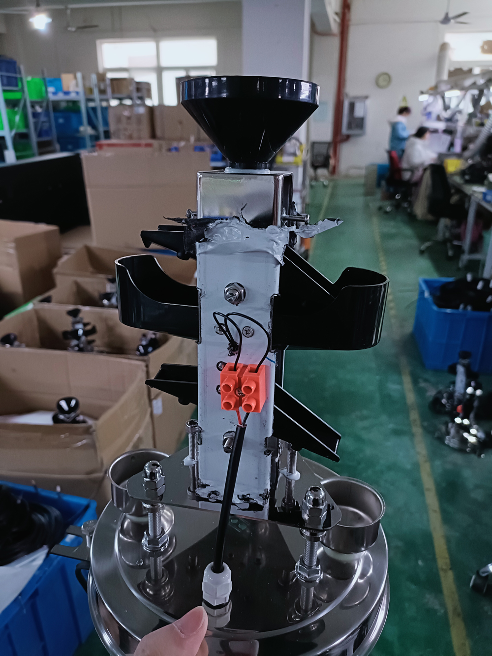
The NiuBoL radar water level and rainfall monitoring system consists of a radar water level sensor, rainfall sensor, data collector, protective box, pole bracket, and power supply system. The data collector has functions such as water level and rainfall data collection, real-time clock, timed storage, parameter setting, and historical data power-down protection. Standard RS232/RS485 communication interfaces support the MODBUS protocol and can be optionally equipped with GPRS/4G/5G wireless modules or wireless data transmission stations to achieve remote data transmission and networking with central stations.
The power supply system provides multiple solutions such as solar power supply, wind-solar complementary, AC 220V, or DC 5V/12V to adapt to different site conditions. The field protective box uses corrosion-resistant and anti-interference materials to ensure stable operation of the equipment in harsh environments. The system has complete lightning protection measures, and both hardware and software adopt modular open designs, facilitating flexible combination and later expansion.
Core system advantages include:
Non-contact measurement, no impact on water flow, no need to build wave-proof wells.
Measurement accuracy reaches millimeter level, with a range covering more than 30 meters.
Continuous online collection supports solar power supply to achieve unattended operation.
Not affected by water quality changes, floating debris, or sediments, with low maintenance costs.
Simple installation and maintenance, with long equipment service life.
River water level monitoring is the basic work of water conservancy projects, flood prevention and waterlogging control, and water transport management. River engineering characteristic water levels mainly include guaranteed water level (flood prevention water level), warning water level, and guaranteed water level (design flood water level). Accurate water level data directly serves flood prevention scheduling, embankment safety assessment, and hydrological data compilation, and also provides a basis for deriving other hydrological parameters such as flow and velocity.
The NiuBoL river water level monitoring station adopts K-band planar radar technology to simultaneously measure water level and flow velocity in a non-contact manner and calculate real-time cross-section flow and cumulative flow according to built-in algorithms. The system is not affected by temperature, sediment, pollutants, or floating objects on the water surface. It features low power consumption, compact size, high reliability, and convenient maintenance.
Typical application areas include:
Comprehensive monitoring of water level, flow velocity, flow, and rainfall in rivers, lakes, tidal waters, reservoir gates, underground drainage pipe networks, and irrigation canals.
Urban water supply, sewage monitoring, and water treatment auxiliary operations.
Flow calculation and real-time monitoring of inflow and drainage flow.
Mountain flood disaster early warning, river flood prevention, and water conservancy project safety operation assurance.
In actual engineering, the system can be docked with existing SCADA or water conservancy IoT platforms to achieve remote data transmission, over-limit alarms, and trend analysis, providing timely and reliable basis for flood prevention command.

Before installation, check the equipment list, including the radar water level gauge sensor, supporting nuts, certificate of conformity, and warranty card. The installation process needs to focus on two points: first, ensure the instrument is perpendicular to the water surface — tilting will weaken the signal amplitude and affect ranging accuracy; second, avoid interference objects (such as riverbanks, bridge piers, or large floating objects) within the emission beam range to prevent false echoes.
The recommended installation location should be a section with open water surface and stable flow pattern, fixed in combination with poles or bridge bodies to ensure no obstruction within the beam angle coverage. During on-site debugging, real-time data can be read through the RS485 interface to verify measurement stability before formal operation.
The NiuBoL radar water level and rainfall monitoring system is widely applicable to the following engineering scenarios:
River and Lake Reservoir Water Level Monitoring: Real-time grasp of guaranteed water level, warning water level, and design flood water level dynamics to support flood prevention decisions.
Irrigation Canal and Open Channel Flow Measurement: Non-contact measurement of water level and flow velocity to calculate cross-section flow and serve irrigation water resource scheduling.
Mountain Flood Disaster Early Warning: Combined with rainfall data to achieve short-term forecasting and emergency response.
Underground Pipe Network and Urban Waterlogging Monitoring: Adapt to narrow spaces and complex water quality environments.
Hydrological Station Upgrade and Renovation: Modular design facilitates integration with existing systems and reduces renovation costs.
The engineering value is reflected in four aspects: first, high measurement accuracy and not affected by environmental factors, ensuring data reliability; second, low power consumption and solar power supply solutions reduce operation and maintenance investment; third, non-contact design reduces equipment damage risk and extends service life; fourth, open communication interfaces (RS485, MODBUS, GPRS/4G/5G) facilitate system integrators to quickly dock with upper platforms.
Q1. What are the main advantages of radar water level sensors compared with traditional contact water level gauges?
Radar water level adopts non-contact measurement, is not affected by floating objects, sediment, and water quality changes, has low maintenance volume, and is suitable for long-term unattended applications in the field.
Q2. What is the maximum measurement range of the NiuBoL radar water level gauge?
The maximum range can reach 65m, with a blind zone within 15cm, meeting the water level monitoring needs of most rivers, lakes, and reservoirs.
Q3. What communication methods does the system support?
It supports RS485 (MODBUS protocol) and can be optionally equipped with GPRS/4G/5G wireless modules or wireless data transmission stations for convenient remote data transmission.
Q4. What issues need the most attention when installing a radar water level gauge?
The sensor must be perpendicular to the water surface, and there must be no interference objects within the beam range to avoid false echoes affecting measurement accuracy.
Q5. What parameters can the river water level monitoring station measure simultaneously?
It can simultaneously measure water level, flow velocity, flow, and rainfall, and output real-time cross-section flow and cumulative flow according to algorithms.
Q6. Can solar power supply meet the long-term operation requirements in the field?
The system adopts a low-power design (maximum 0.6W). Combined with solar or wind-solar complementary power supply, it can achieve unattended operation in harsh environments.
Q7. Is radar water level measurement accuracy greatly affected by water surface fluctuations?
The system performs 55 samplings per second and uses digital filtering processing to effectively suppress the influence of fluctuations, with measurement results close to still water level.
Q8. How to choose the appropriate radar water level monitoring configuration during project integration?
Choose basic water level type or water level-flow-rainfall integrated solution according to monitoring range, site environment, and communication needs, supporting modular expansion.
The radar water level and rainfall monitoring system plays an important role in water conservancy monitoring projects with its non-contact, high-precision, and strong adaptability characteristics. The NiuBoL radar water level gauge and river water level monitoring station are based on advanced FMCW and K-band radar technology, providing millimeter-level precision measurement and flexible communication interfaces, offering stable and reliable hardware solutions for system integrators, IoT solution providers, and engineering companies.
Through scientific selection and standardized installation, the continuity and accuracy of river water level, flow, and rainfall monitoring can be effectively improved, supporting flood prevention and early warning, water resource management, and safe operation of water conservancy projects. If you need technical parameters, system configuration, or integration scheme support for specific project scenarios, please contact the NiuBoL professional team to jointly promote the stable implementation of water conservancy monitoring projects.
 NBL-W-RS-Rain-sensors-instruction-manual-V4.0.pdf
NBL-W-DRS-Double-Tipping-Bucket-Rain-Sensor-Instruction-Manual.pdf
Related recommendations
Sensors & Weather Stations Catalog
Agriculture Sensors and Weather Stations Catalog-NiuBoL.pdf
Weather Stations Catalog-NiuBoL.pdf
Agriculture Sensors Catalog-NiuBoL.pdf
Water Quality Sensor Catalog-NiuBoL.pdf
Related products
 Combined air temperature and relative humidity sensor
 Soil Moisture Temperature sensor for irrigation|NBL-S-THR
 Soil pH sensor RS485 soil Testing instrument soil ph meter for agriculture |NBL-S-PH
 Wind Speed sensor Output Modbus/RS485/Analog/0-5V/4-20mA
 Tipping bucket rain gauge for weather monitoring auto rainfall sensor RS485/Outdoor/stainless steel
 Pyranometer Solar Radiation Sensor 4-20mA/RS485

Screenshot, WhatsApp to identify the QR code
WhatsApp number:+8615367865107
(Click on WhatsApp to copy and add friends)
