


— Blogs —
—Products—
 Consumer hotline +8618073152920
 WhatsApp:+8615367865107
Address:Room 102, District D, Houhu Industrial Park, Yuelu District, Changsha City, Hunan Province, China
Product knowledge
Time:2025-12-09 14:50:33 Popularity:678
With the rapid development of information technology and increasingly complex challenges in water resource management, traditional water conservancy management models can no longer meet the needs of modern society. Against this backdrop, Smart Water Conservancy has emerged as the higher stage of water conservancy informatization construction.

Smart Water Conservancy leverages advanced technologies such as the Internet, cloud computing, big data, and geographic information systems (GIS) to pursue the core goals of “digitization, networking, visualization, and intelligence,” transforming water conservancy operations from traditional modes to intelligent decision-making and services.
In short, Smart Water Conservancy establishes a comprehensive, full-process, full-business intelligent water management system, achieving more thorough, flexible, and efficient interconnection and mutual perception among objects, between objects and people, and among people within the water conservancy sector.
The essence of Smart Water Conservancy lies in achieving the following key capability improvements:
Comprehensive perception and interconnection: Enhancing interconnectivity and mutual awareness of various water engineering facilities and hydrological elements.
Information processing and resource integration: Building efficient and secure platforms for information processing and water resource integration.
Scientific decision-making and early warning: Enabling more scientific monitoring, forecasting, analysis, prediction, and decision-making, especially in flood control and drought resistance.
Intelligent execution: Improving remote control and intelligent operation of water facilities (e.g., automatic opening/closing of sluice gates and pump stations).
Cross-departmental collaboration: Promoting coordinated cooperation across departments, levels, and locations in water conservancy operations.
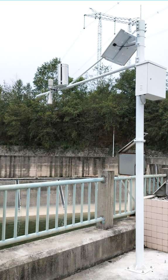
The Smart Water Conservancy system is a complex integrated entity that tightly combines front-end sensing devices, transmission networks, and back-end management platforms to form an efficient closed-loop operation.
Hydrological monitoring activities typically consist of the following four major parts:
Measurement equipment (front-end perception): The system’s “eyes,” including rain gauges, water level gauges, flow meters, water quality instruments, etc., used for real-time collection of on-site hydrological and water quality parameters.
Front-end monitoring terminal (RTU): Also known as hydrological remote terminal unit, responsible for real-time signal acquisition from measurement devices and preliminary data processing according to hydrological communication protocols.
Communication network (transmission channel): Including GPRS/LoRa/4G/5G, public Internet, etc., ensuring real-time and reliable transmission of collected data to the monitoring center.
Monitoring center (platform brain): Composed of servers, dedicated lines, and hydrological monitoring system software, responsible for real-time data display, storage, professional analysis, warning issuance, and remote control.
By integrating multi-source data, the Smart Water Conservancy system achieves comprehensive monitoring of the following key information:
1. Integrated Meteorological and Hydrological Monitoring
Rainfall and meteorology: Integrating meteorological stations and weather radar data to comprehensively monitor precipitation, evaporation, runoff, etc., supporting disaster weather warnings and hydrological forecasting.
2. Water Regime and Hydrological Information Monitoring
Water body status: Using GIS technology to visually display the location, scope, and condition of rivers, lakes, reservoirs, and groundwater.
Core parameters: Real-time monitoring of river water levels, flow velocity, discharge, reservoir water levels, etc. Combined with professional models for multi-dimensional analysis and prediction of water regime parameters such as flow, velocity, rainfall (snow), and evaporation.
3. Water Quality and Sediment Monitoring
Water quality safety: Real-time monitoring of pH, dissolved oxygen, ammonia nitrogen, turbidity, and other water quality indicators to ensure water supply safety and water body health.
Sediment changes: Monitoring sediment content in rivers or reservoirs to provide data support for reservoir capacity changes and riverbed scouring/silting dynamics.
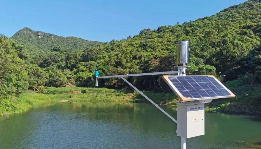
As a professional manufacturer in the field of IoT sensors, NiuBoL Technology focuses on the core of water level monitoring — measurement equipment — and combines advanced communication technologies to provide highly reliable, high-precision front-end sensing devices and systems for Smart Water Conservancy.
NiuBoL’s online hydrological monitoring system can be applied to natural rivers, reservoirs, channels, groundwater, etc., covering monitoring of water level, rainfall/snow, flow, velocity, etc.
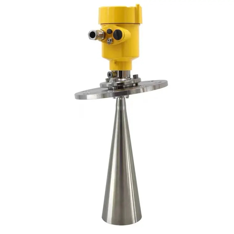
1. Radar Level Gauge (Non-contact Water Level Monitoring)
Principle: The antenna emits extremely narrow microwave pulses that are reflected back upon hitting the water surface. The water level is accurately calculated by measuring the time interval between transmission and reception, thus determining the distance from the antenna to the water surface.
Advantages: Non-contact measurement, unaffected by water quality, temperature, or sediment; high accuracy, simple maintenance, avoiding the damage-prone issues of traditional contact-type equipment.
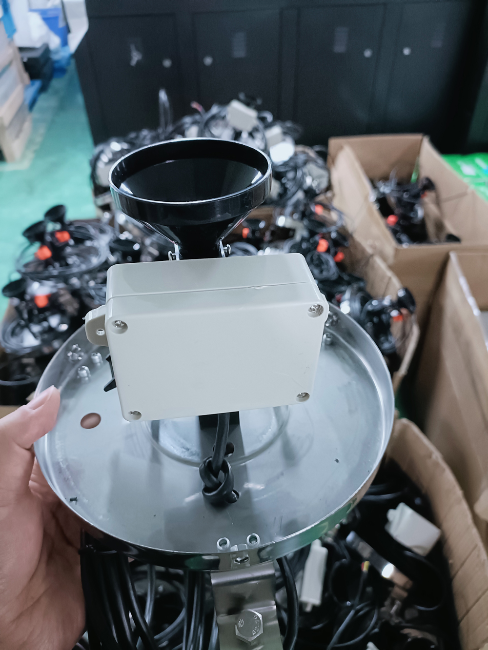
2. NBL-W-RS Tipping-Bucket Rain Gauge
Principle: Uses the tipping-bucket counting principle to convert collected rainfall into pulse outputs according to a standard volume.
Application: Widely used in meteorological stations, hydrological stations, agriculture, forestry, and national defense, providing reliable raw rainfall data for flood warning, water supply systems, and reservoir management.
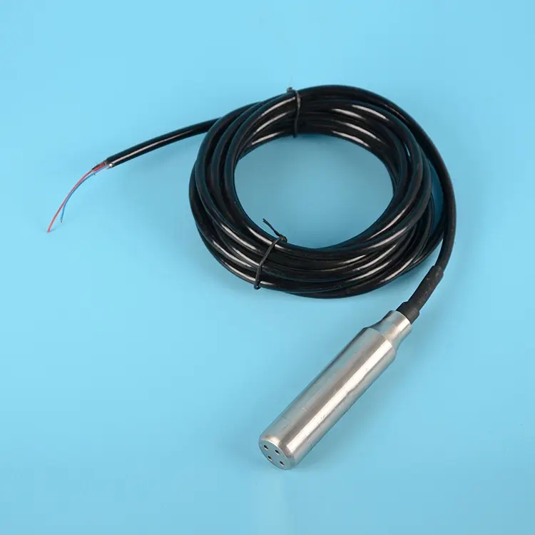
3. Submersible Level Transmitter
Principle: Utilizes a diffused silicon pressure sensor to determine liquid level by measuring the hydrostatic pressure generated by water depth. Special cables with atmospheric vents ensure water tightness and measurement accuracy.
Advantages: Suitable for reservoirs, groundwater, and other static or deep-water environments, delivering accurate and stable measurement data.

NiuBoL’s online hydrological monitoring system offers the following distinctive practical features:
Strong functional scalability: Real-time water level monitoring with flexible expansion to rainfall, water quality, flow velocity, and other parameters.
Alarm and early warning: Supports immediate alarms for water level exceedance, sensor failure, or low terminal battery voltage.
Intelligent linkage: Can link with drainage pumping stations to automatically control pump start/stop based on river water level, achieving intelligent execution.
Remote visualization: Supports remote photo or real-time video monitoring (depending on communication method), helping managers grasp on-site conditions instantly.
The following are answers to frequently asked questions about Smart Water Conservancy systems and NiuBoL products to help you better understand and deploy them.
| Q:Common Questions | A:NiuBoL Answers and Recommendations |
|---|---|
| 1.What exactly are the “four modernizations” at the core of Smart Water Conservancy? | They refer to digitization, networking, visualization, and intelligence. NiuBoL systems achieve digitization through automated collection, networking via 4G/5G, visualization on cloud platforms, and intelligence through linkage warnings. |
| 2.What is the main role of the hydrological monitoring terminal (RTU)? | The RTU is the key device connecting sensors and communication networks, responsible for data acquisition, storage, protocol conversion (hydrological protocol), and executing remote control commands. NiuBoL terminals support multiple sensor signal inputs and report data in compliance with industry-standard protocols. |
| 3.Why is a radar level gauge recommended for water level monitoring? | Radar level gauges offer non-contact measurement with high accuracy, unaffected by floating debris, sediment, or water quality changes, and have low maintenance costs. Especially suitable for rivers and reservoirs prone to freezing or high sediment content. |
| 4.How does a tipping-bucket rain gauge convert rainfall into pulses? | The sensor contains a self-tipping bucket. Each time it collects a standard amount of rainfall (e.g., 0.5 mm), the bucket tips and generates one electrical pulse. NiuBoL sensors are highly accurate and precisely capture rainfall variations. |
| 5.What is the role of the “atmospheric vent tube” in the submersible level transmitter cable? | The vent tube connects the transmitter’s reference pressure to atmospheric pressure, enabling relative pressure measurement. This eliminates errors caused by atmospheric pressure changes — critical for accurate and stable level measurement. |
| 6.What are the data transmission methods in hydrological monitoring? | Mainly mobile networks such as GPRS/4G/5G (fast transmission, wide coverage) and IoT technologies like LoRa (low power, long range). NiuBoL systems flexibly select transmission methods based on site conditions and bandwidth requirements. |
| 7.How is “visualization” achieved in water regime monitoring? | Through GIS and cloud platform software, real-time sensor data is overlaid on electronic maps and displayed intuitively via charts, curves, color blocks, etc. NiuBoL platforms provide rich and diverse visualization interfaces for quick overall water regime awareness. |
| 8.How does the system implement “water level exceedance alarm”? | Managers set safe water level thresholds on the monitoring platform. When RTU-collected water level exceeds the threshold, the system immediately triggers alarms (SMS, phone, pop-up) and records the event. NiuBoL terminals support both local and remote dual alarm functions. |
| 9.How does the hydrological system achieve linkage control with drainage pumping stations? | By integrating a remote control module in the RTU, when river water level reaches the preset start level, the system automatically sends commands to the pump station control equipment to activate drainage pumps. This is a key embodiment of “intelligent execution capability” in Smart Water Conservancy. |
| 10.What will be the key directions for future water conservancy project construction? | Focus will be on major water diversion projects, key water source projects, and backbone projects for river and lake governance to address resource-based and engineering water shortages and defects in flood control systems. NiuBoL’s online monitoring systems will serve as critical technical support for the construction and operation of these major projects. |
Smart Water Conservancy is the inevitable trend in the development of modern water conservancy. Supported by advanced information technology, it achieves digitization, networking, and intelligence in water management, significantly enhancing the capabilities of water authorities in flood control and disaster reduction, water supply security, and ecological protection.
As a provider of core sensing equipment, NiuBoL Technology has successfully built highly reliable online hydrological monitoring systems through its high-precision radar level gauges, tipping-bucket rain gauges, and other products. These systems not only collect critical data such as water level and rainfall in real time and accurately but also provide solid technical foundation and demonstration effects for flood control and disaster reduction across regions through intelligent warnings and linkage control.
In the future, with sustained national investment in water conservancy and accelerated construction of major water projects, IoT sensors and intelligent monitoring systems represented by NiuBoL will embrace broader market opportunities, continuously safeguarding refined global water resource management and healthy water environments.
Related recommendations
Sensors & Weather Stations Catalog
 Agriculture Sensors and Weather Stations Catalog-NiuBoL.pdf
Weather Stations Catalog-NiuBoL.pdf
Agriculture Sensors Catalog-NiuBoL.pdf
Water Quality Sensor Catalog-NiuBoL.pdf
Related products
 Combined air temperature and relative humidity sensor
 Soil Moisture Temperature sensor for irrigation|NBL-S-THR
 Soil pH sensor RS485 soil Testing instrument soil ph meter for agriculture |NBL-S-PH
 Wind Speed sensor Output Modbus/RS485/Analog/0-5V/4-20mA
 Tipping bucket rain gauge for weather monitoring auto rainfall sensor RS485/Outdoor/stainless steel
 Pyranometer Solar Radiation Sensor 4-20mA/RS485

Screenshot, WhatsApp to identify the QR code
WhatsApp number:+8615367865107
(Click on WhatsApp to copy and add friends)
