


— Blogs —
—Products—
 Consumer hotline +8618073152920
 WhatsApp:+8615367865107
Address:Room 102, District D, Houhu Industrial Park, Yuelu District, Changsha City, Hunan Province, China
Product knowledge
Time:2026-04-08 11:19:57 Popularity:341
China's per capita water resource possession is extremely low and unevenly distributed. For a long time, the monitoring system for large rivers has been relatively complete, but small and medium rivers, which are widely distributed and strongly affected by human activities, are the weak link in hydrological monitoring.
Geological disaster warning: Small and medium rivers are mostly located in areas prone to mountain floods and debris flows. High-frequency water level and rainfall monitoring is the most basic information source for realizing mountain flood warning and ensuring the safety of lives and property.
Runoff generation and confluence mechanism research: With the urbanization process, underlying surface conditions (such as increased impervious area) have undergone tremendous changes. Collecting raw data through hydrological monitoring is the key to studying modern urban hydrology and predicting water environment trends.
Basis for water ecological protection: Monitoring groundwater level fluctuations and seawater intrusion, river drying and other phenomena provides technical support for national water rights allocation and ecological red line formulation.

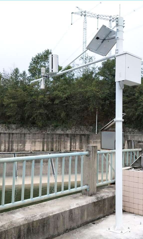
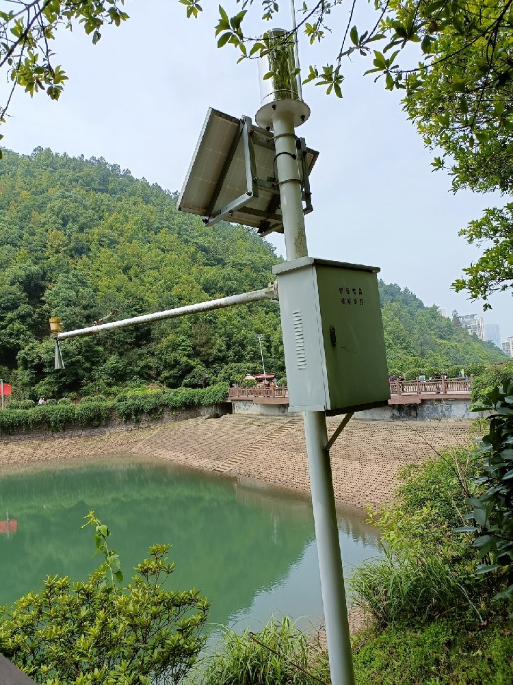
A standardized NiuBoL automatic hydrological monitoring station consists of five core units to ensure a closed loop from the field environment to the monitoring center:
Perception layer (hydrological sensors): responsible for collecting physical/chemical indicators such as water level, flow velocity, water quality and rainfall.
Acquisition layer (data collector): the system brain. Built-in large-capacity FLASH storage, supporting timed storage, parameter setting and friendly human-machine interface.
Power supply layer (solar system): designed for field unattended conditions, equipped with high-performance photovoltaic panels and battery packs.
Support layer (pole bracket): industrial-grade anti-corrosion treatment to ensure physical stability under harsh meteorological conditions.
Application layer (cloud platform software): provides remote data dashboard, abnormal alarm push and historical data export functions.

In smart water projects, sensor selection directly determines system reliability and maintenance cost. The following are the core sensors recommended by NiuBoL and their engineering value.
Water level is the first element of hydrological monitoring. NiuBoL provides contact and non-contact solutions to adapt to different river environments.
Radar Water Level Gauge: Uses millimeter-wave technology, non-contact measurement, not affected by floating objects and sediment, with accuracy up to millimeter level.
Pressure Water Level Gauge: Based on hydrostatic pressure principle, high sensitivity, suitable for deep wells or pipe networks with limited installation environment.
Flow velocity data is the key to calculating cross-section flow.
Radar Flow Velocity Meter: Planar radar technology, non-contact detection of water surface flow velocity, excellent performance during flood peaks, avoiding the risk of mechanical rotating flow velocity meters being entangled by water weeds.

Core tools for monitoring “three wastes” discharge and water source protection.
Five-parameter integrated monitoring: includes pH, conductivity, dissolved oxygen, turbidity and temperature. These indicators intuitively reflect the pollution degree and self-purification capacity of water bodies.
Key to meteorological and hydrological coupling.
Tipping Bucket Rain Gauge: Industrial-grade stainless steel material, pulse output, providing high-resolution rainfall intensity data, which is the core parameter for calculating runoff coefficient.

| Sensor Type | Measurement Technology | Measurement Range | Core Value |
|---|---|---|---|
| Radar Water Level Gauge | 77GHz millimeter wave | 0.15m - 65m | Non-contact, maintenance-free, strong anti-fluctuation ability |
| Radar Flow Velocity Meter | 24GHz Doppler | 0.1 - 20m/s | High reliability, suitable for complex sections, anti-floating objects |
| Pressure Water Level Gauge | Piezoresistive / silicon resonance | 0 - 100m | Easy to hide installation, moderate cost |
| Rain Gauge | Tipping bucket | 0 - 4mm/min | Flood warning, rainfall intensity monitoring |
| Multi-parameter Water Quality Meter | Electrochemical / optical | Customized by parameter | Pollution source tracing, ecological early warning |

1. Small and Medium River Flood Warning
Recommended configuration: radar water level gauge + tipping bucket rain gauge + 4G collector.
By monitoring the correlation between water level rise rate and real-time rainfall, engineering contractors can build flood evolution models for local governments and achieve second-level warning.
2. Urban Drainage Pipe Network Monitoring
Recommended configuration: pressure water level gauge + ultrasonic Doppler flow velocity meter.
Underground pipe network space is narrow and corrosive. This scheme can effectively monitor waterlogging risks and illegal sewage discharge.
3. Reservoir and Irrigation Area Management
Recommended configuration: radar flow meter + solar power supply system.
Realize non-contact irrigation canal water level and flow statistics to assist water-saving irrigation and water rights trading digitization.
NiuBoL hydrological station supports multiple standard communication modes to ensure that system integrators can quickly access existing SCADA or smart platforms:
Physical interface: standard RS485, supports Modbus-RTU protocol.
Wireless link: built-in 4G/5G module, supports offline continuation and remote configuration.
Data security: collector has local data power-down protection, combined with encrypted transmission to ensure the confidentiality of materials required by the Ministry of Water Resources.

When delivering projects, integrators can use the multi-parameter interfaces provided by NiuBoL to achieve cross-business collaboration.
| Business Pain Point | Sensor Combination Scheme | Linkage Decision Support (Action) |
|---|---|---|
| Mountain flood disaster warning | Radar water level gauge + tipping bucket rain gauge | Automatic warning: linkage with village entrance loudspeakers for broadcast and sending evacuation SMS |
| Sewage outlet tracing | pH / conductivity sensor + flow meter | Evidence retention: automatically trigger sampler for sample retention or dome camera capture when abnormal fluctuation occurs |
| Agricultural water-saving irrigation | Radar flow meter + soil moisture sensor | Closed-loop control: automatically adjust gate opening according to crop water demand and channel flow |
| Groundwater monitoring | Pressure water level gauge + conductivity meter | Seawater intrusion assessment: monitor salinity changes and guide groundwater extraction control |

1. What is the difference in maintenance cycle between radar water level gauge and submersible water level gauge?
A: Since the radar water level gauge is non-contact measurement, the probe does not contact corrosive water or silt, and usually does not require regular cleaning and calibration. Its service life is much longer than that of submersible sensors that require regular membrane replacement, greatly reducing engineering operation and maintenance costs.
2. How do sensors cope with freezing or high-heat environments?
A: NiuBoL sensor core components operate in a temperature range from -40°C to +80°C. For extremely cold areas, we provide optional low-power heating components to ensure data does not drop when the water surface freezes.
3. How does the system maintain operation during continuous rainy days?
A: Our collector has extremely low power consumption (<0.5W). Combined with intelligent power management modules, equipped with 20W solar panels and 20Ah batteries, the system can support continuous operation for 15-21 days in complete absence of light.
4. Do the sensors support secondary development?
A: Yes. We provide complete Modbus register manuals and secondary development protocols. Integrators can write calculation formulas or logic triggers on the upper computer platform according to project requirements.
5. Are multi-parameter water quality sensors prone to drift?
A: All electrochemical water quality sensors have physical drift characteristics. NiuBoL uses high-performance industrial-grade electrodes and recommends calibration with standard solutions every 3-6 months. For projects with high precision requirements, it is recommended to select optional automatic cleaning brushes.

6. How to select brackets for small and medium river installation?
A: We provide L-type cross-arm brackets (for bridge installation) and T-type floor-standing brackets. The brackets are treated with hot-dip galvanizing, and the wind resistance grade design complies with national standards to ensure that the water level gauge does not shift during flood peaks.
7. What is the real-time performance of the data?
A: The collection frequency is adjustable, with the fastest support for one collection per second. For most hydrological stations, it is recommended to set 10 minutes or 1 hour as the reporting interval to balance real-time performance and power consumption.
8. How do multi-parameter water quality sensors handle the “biological film” problem?
A: In static water bodies or rivers with severe eutrophication, sensor probes are prone to algae growth. NiuBoL optical turbidity and dissolved oxygen sensors can be equipped with optional automatic scraping brushes to regularly clean optical windows and ensure long-term monitoring without drift.
9. For small and medium rivers with narrow channels and dense trees, will radar waves be interfered with?
A: NiuBoL radar water level gauge has an 8° narrow beam angle. As long as there are no overhanging branches or debris within 0.5 meters of the center line from the installation point to the water surface, precise sensing can be achieved. In restricted spaces, we recommend using custom telescopic cantilever brackets.
10. Does the installation of this system require a special civil engineering foundation?
A: No large-scale civil engineering is required. NiuBoL provides supporting pre-embedded flange plates and lightweight poles. Only a 0.5m*0.5m concrete base needs to be poured on the shore, and assembly can be completed by one person.
Solving water environment problems is not achieved overnight and relies on long-term, high-granularity data support. NiuBoL assists system integrators in delivering commercially competitive and stably operating monitoring projects in the fields of water conservancy, environmental protection and municipal affairs by providing industrial-grade and highly reliable hydrological sensing hardware.
Choosing NiuBoL means choosing a professional partner that can cope with harsh field working conditions and provide full life-cycle technical support. We are committed to making every drop of water flow clearly visible through technical means.
Copyright © NiuBoL. This article aims to provide technical guidance for smart water engineering solutions. For detailed product specifications and procurement quotations, please contact our technical sales team.
Next:NiuBoL Agricultural IoT Four-Condition Monitoring Solution Helps Precision Agriculture Management
Related recommendations
Sensors & Weather Stations Catalog
 Agriculture Sensors and Weather Stations Catalog-NiuBoL.pdf
Weather Stations Catalog-NiuBoL.pdf
Agriculture Sensors Catalog-NiuBoL.pdf
Water Quality Sensor Catalog-NiuBoL.pdf
Related products
 Combined air temperature and relative humidity sensor
 Soil Moisture Temperature sensor for irrigation|NBL-S-THR
 Soil pH sensor RS485 soil Testing instrument soil ph meter for agriculture |NBL-S-PH
 Wind Speed sensor Output Modbus/RS485/Analog/0-5V/4-20mA
 Tipping bucket rain gauge for weather monitoring auto rainfall sensor RS485/Outdoor/stainless steel
 Pyranometer Solar Radiation Sensor 4-20mA/RS485

Screenshot, WhatsApp to identify the QR code
WhatsApp number:+8615367865107
(Click on WhatsApp to copy and add friends)
