


— Blogs —
—Products—
 Consumer hotline +8618073152920
 WhatsApp:+8615367865107
Address:Room 102, District D, Houhu Industrial Park, Yuelu District, Changsha City, Hunan Province, China
Product knowledge
Time:2025-12-10 11:55:10 Popularity:382

Smart Transportation (Intelligent Transportation System, ITS) is a modern transportation system that comprehensively applies next-generation information technologies such as IoT, spatial perception, cloud computing, and mobile internet across the entire transportation sector, while integrating traffic science, systems engineering, artificial intelligence, and knowledge mining theories and tools.
Its core objective is to build a real-time dynamic information service system, deeply mine transportation-related data, and form problem analysis models to achieve:
Comprehensive perception: Real-time, multi-dimensional data collection of road networks, vehicles, and environment.
Deep integration: Full integration of collected data with information technology to eliminate information silos.
Proactive service: Personalized and precise information services for the public and managers.
Scientific decision-making: Data support for resource allocation, public policy, and industry management.
The ultimate goal is to make transportation safer, more efficient, more convenient, more economical, more environmentally friendly, and more comfortable while driving the transformation and upgrading of related industries. Future highways are focusing on creating remote “visible, measurable, controllable, and serviceable” smart road networks.

With the rapid development of highways, “traffic safety issues caused by meteorological environment changes” have become a major difficulty in smart transportation construction. Against the backdrop of global climate change, extreme weather events such as typhoons, heavy rain, snowstorms, and dense fog are increasing year by year, posing significant safety risks to vehicles and severely impacting transportation efficiency and public safety.
Therefore, building a real-time monitoring and early warning system for adverse road weather conditions is urgently needed. Accurate meteorological monitoring is key to ensuring all-weather highway passability and effectively reducing traffic accidents.
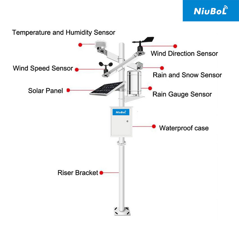
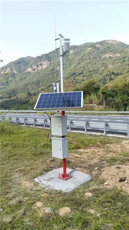
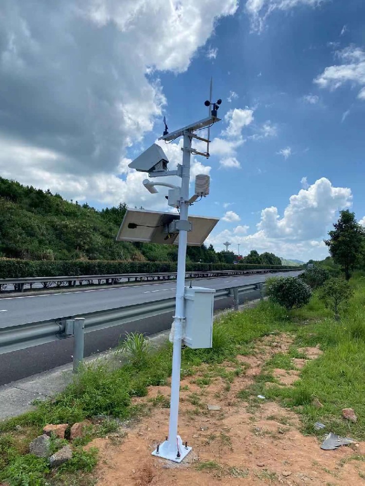
A Road Weather Station (also known as Highway Weather Station or Multi-Element Road Weather Instrument) is the core component for delivering “smart highway” weather services.
Road weather stations integrate multiple meteorological sensors using comprehensive acquisition control technology, computer software, and communication technology.
System Composition:
• Meteorological sensors: Real-time acquisition of various elements (visibility sensor, road condition sensor, air temp/humidity/pressure, rainfall, rain/snow, wind speed/direction, etc.)
• Data logger: Collects, processes, and formats sensor signals
• Mounting pole/bracket: Fixes and installs equipment
• Power supply system: Ensures continuous operation
• Cloud platform/communication system: Remotely transmits data to traffic management departments
Road weather stations continuously and in real time acquire key meteorological information along transportation routes, primarily monitoring:
Visibility • Wind speed & direction • Temperature, humidity, atmospheric pressure • Rainfall • Road surface condition (ice, snow, water, dry/wet) • Snow depth
With these real-time data, transportation authorities can provide timely warnings and information services to highway safety departments and the public.
NiuBoL’s dedicated road weather station is a comprehensive monitoring system that integrates automatic observation, remote control, and wireless transmission, focusing on visibility, weather phenomena, and road surface conditions.
| Product Model | Monitoring Elements | Core Principle/Technology | Application Advantages & Features |
|---|---|---|---|
NBL-W-VS Visibility Meter | Meteorological visibility | Forward light scattering principle | Helps traffic authorities quickly grasp conditions, especially in fog, improving driving safety and reducing accidents |
NBL-W-RSCS Road Surface Condition Sensor | Road icing, snow, water, dry/wet, thickness | Non-contact remote sensing, multi-spectral measurement | No road damage or traffic interference. 24/7 continuous monitoring and road condition diagnosis |
NBL-W-LBTH Air Temp/Humidity/Pressure Sensor | Air temperature, relative humidity, pressure | Integrated sensing technology | Provides scientific basis for road management measures; usually equipped with radiation shield |
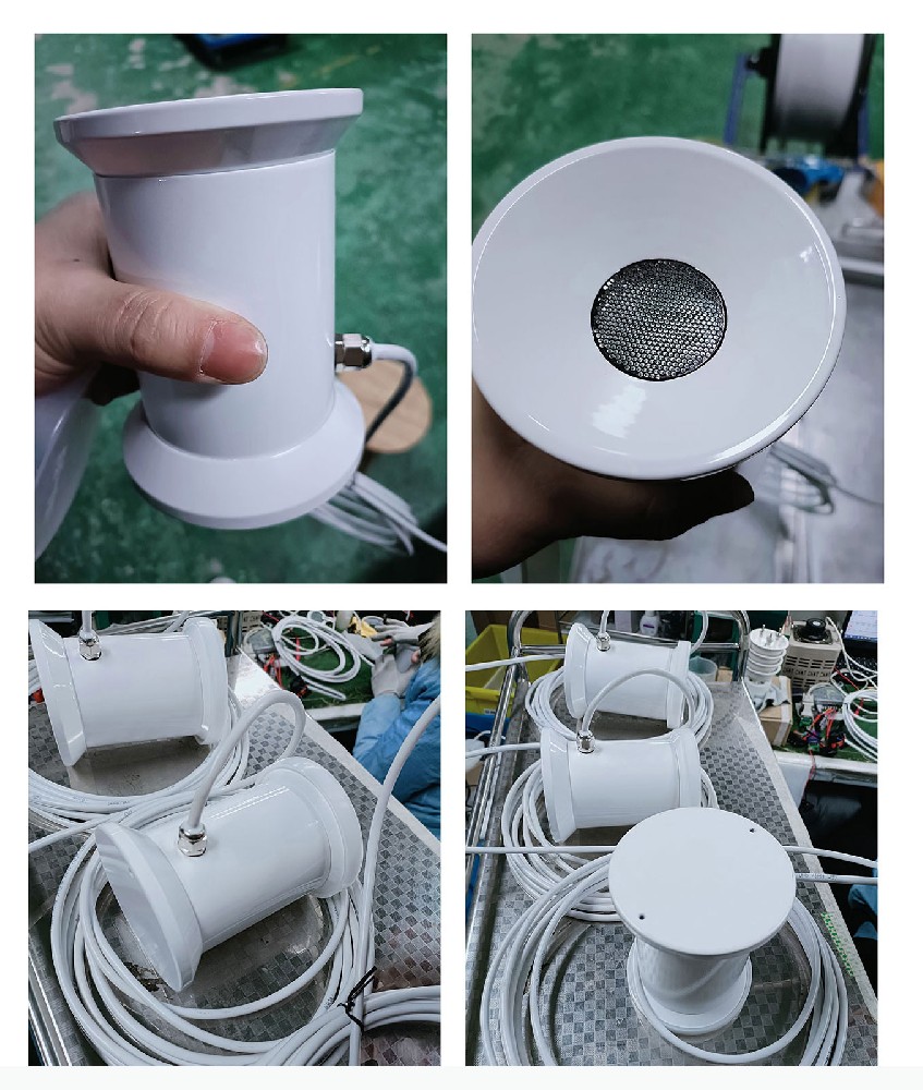
NBL-W-RS Rainfall Sensor | Rainfall amount | Tipping-bucket principle (pulse output) | Realizes rainwater collection, analysis, and intelligent warning; assists traffic flow management |
NBL-W-SS | Wind speed | Sensitive three-cup design | Carbon fiber material, high strength. Predicts typhoon and strong wind risks |
NBL-W-DS | Wind direction | High-precision magnetic chip, low-inertia lightweight vane | Good linearity, strong lightning resistance. Helps improve road capacity and timely warnings |
NBL-W-SNOW | Snow depth | Ultrasonic remote measurement | Automated continuous snow depth monitoring via ultrasonic time-of-flight |
1. What is the essential difference between smart transportation and traditional traffic management?
The essential difference lies in the deep application of information technology. Traditional management relies on human experience, fixed signals, and limited monitoring — passive management. Smart transportation uses IoT, cloud computing, and big data for comprehensive perception, real-time interaction, and scientific decision-making — proactive and predictive management.
2. Where are road weather stations mainly deployed?
Primarily on weather-sensitive sections affecting driving safety: highway sections, key bridges, tunnel entrances, sharp bends, steep slopes, accident-prone areas, fog-prone sections, airport runways, and railway lines.
3. How does the NBL-W-RSCS road condition sensor achieve “non-contact” detection?
It uses remote sensing technology (infrared/multi-spectral) to analyze reflected signal characteristics (spectral absorption, reflectivity) and determine road surface state and ice/snow thickness without cutting the road or interfering with traffic.
4. How is road weather station data used in traffic management?
• Early warning: Automatic alerts when visibility, wind speed, or icing exceed thresholds
• Traffic guidance: Real-time information via VMS boards or mobile apps
• Decision support: Basis for speed limits, road closures, or de-icing operations
5. How does the power system ensure field operation?
In areas without mains power, solar panels + batteries are used. NiuBoL sensors and loggers are low-power designs that operate continuously even during prolonged rainy weather.
6. What is the forward scattering principle of the NBL-W-VS visibility meter?
Light scatters when passing through suspended particles (fog droplets, dust). The meter emits a light pulse and measures forward-scattered light intensity received at a forward angle. Stronger scattering indicates more particles and lower visibility, converted via algorithm into meteorological visibility value.
7. Why use carbon fiber for wind speed sensor cups?
High strength to withstand strong winds; lightweight for low inertia, lower starting threshold, and faster response — accurately measuring light winds; excellent corrosion resistance for long-term outdoor use.
8. What does “serviceable” mean in a smart road network?
The system proactively provides personalized services: optimal route guidance based on real-time weather/traffic, personalized danger warnings, and rapid emergency resource dispatch during accidents.
9. Is the ultrasonic snow depth measurement affected by temperature?
Yes — sound speed varies with temperature. Professional sensors like NBL-W-SNOW include built-in temperature compensation to correct sound speed in real time, ensuring snow depth accuracy.
10. How to improve response speed to extreme weather?
High-frequency real-time monitoring, low-latency communication (RS485, 4G/5G), and edge computing for rapid on-site decision-making.
Q11: What certifications does NiuBoL have?
A11: CE, ISO9001, RoHS, and nationally recognized meteorological calibration certificates.
Smart transportation is a modern model that uses next-generation information technology to achieve efficient, safe, and convenient transportation operations. Among them, road weather environment monitoring is the core foundation for ensuring all-weather passability of “smart highways.”
NiuBoL’s road weather monitoring system, with its high-precision visibility meters, non-contact road condition sensors, and other professional products, builds reliable, stable, and safe road weather stations. It provides traffic management departments with real-time, scientific, and comprehensive meteorological and road data — the key support for realizing “visible, measurable, controllable, and serviceable” smart road networks.
 NBL-W-RSS-Rain-Snow-Sensor-instruction-manual.pdf
NBL-W-RS-Rain-sensors-instruction-manual-V4.0.pdf
NBL-W-DRS-Double-Tipping-Bucket-Rain-Sensor-Instruction-Manual.pdf
Prev:NiuBoL Smart City Environmental Monitoring Solution – Full Analysis
Next:Road Weather Monitoring: IoT Technology in Road Safety Early Warning Applications & Practice
Related recommendations
Sensors & Weather Stations Catalog
Agriculture Sensors and Weather Stations Catalog-NiuBoL.pdf
Weather Stations Catalog-NiuBoL.pdf
Agriculture Sensors Catalog-NiuBoL.pdf
Water Quality Sensor Catalog-NiuBoL.pdf
Related products
 Combined air temperature and relative humidity sensor
 Soil Moisture Temperature sensor for irrigation|NBL-S-THR
 Soil pH sensor RS485 soil Testing instrument soil ph meter for agriculture |NBL-S-PH
 Wind Speed sensor Output Modbus/RS485/Analog/0-5V/4-20mA
 Tipping bucket rain gauge for weather monitoring auto rainfall sensor RS485/Outdoor/stainless steel
 Pyranometer Solar Radiation Sensor 4-20mA/RS485

Screenshot, WhatsApp to identify the QR code
WhatsApp number:+8615367865107
(Click on WhatsApp to copy and add friends)
